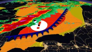
Active Alerts Adsul, TX
...The Flood Warning continues for the following rivers inLouisiana...Texas...Calcasieu River near White Oak ParkCalcasieu River Near GlenmoraSabine River Near Bon WierSabine River Near Deweyville...The Flood Warning is extended for the following rivers in Texas...Louisiana...Sabine River Near BurkevilleAdditional information is available at www.weather.gov.The next statement will be issued Wednesday evening at 815 PM CDT.* WHAT...Minor flooding is occurring and minor flooding is forecast.* WHERE...Sabine River near Burkeville.* WHEN...Until early Friday morning.* IMPACTS...At 40.0 feet, Moderate flooding occurs.* ADDITIONAL DETAILS...- At 7:15 PM CDT Tuesday the stage was 39.8 feet.- Recent Activity...The maximum river stage in the 24 hoursending at 7:15 PM CDT Tuesday was 40.8 feet.- Forecast...The river is expected to fall below flood stageearly Thursday afternoon and continue falling to 35.7 feetSunday evening.- Flood stage is 36.0 feet.- http://www.weather.gov/safety/flood
...The Flood Warning continues for the following rivers inLouisiana...Texas...Calcasieu River near White Oak ParkCalcasieu River Near GlenmoraSabine River Near Bon WierSabine River Near Deweyville...The Flood Warning is extended for the following rivers in Texas...Louisiana...Sabine River Near BurkevilleAdditional information is available at www.weather.gov.The next statement will be issued Wednesday evening at 815 PM CDT.* WHAT...Moderate flooding is occurring and moderate flooding isforecast.* WHERE...Sabine River near Bon Wier.* WHEN...Until further notice.* IMPACTS...At 36.0 feet, Major lowland flooding will occur. SabineSands Road has about one to three feet of water covering the road.* ADDITIONAL DETAILS...- At 7:15 PM CDT Tuesday the stage was 35.6 feet.- Recent Activity...The maximum river stage in the 24 hoursending at 7:15 PM CDT Tuesday was 35.7 feet.- Forecast...The river is expected to fall to 32.2 feet Sundayevening.- Flood stage is 30.0 feet.- http://www.weather.gov/safety/flood