Cold air damming can grip towns in a lengthy, frigid gloom

Cold winds blowing against the mountains can create a unique and annoying phenomenon for communities in the foothills
Brisk winds sweeping over jagged mountains give rise to breathtaking clouds as they crest the peaks, then fall down the other side as some of the most vicious winds that blow across the Canadian landscape.
But sometimes the biggest influence these chains can play is simply getting in the way.
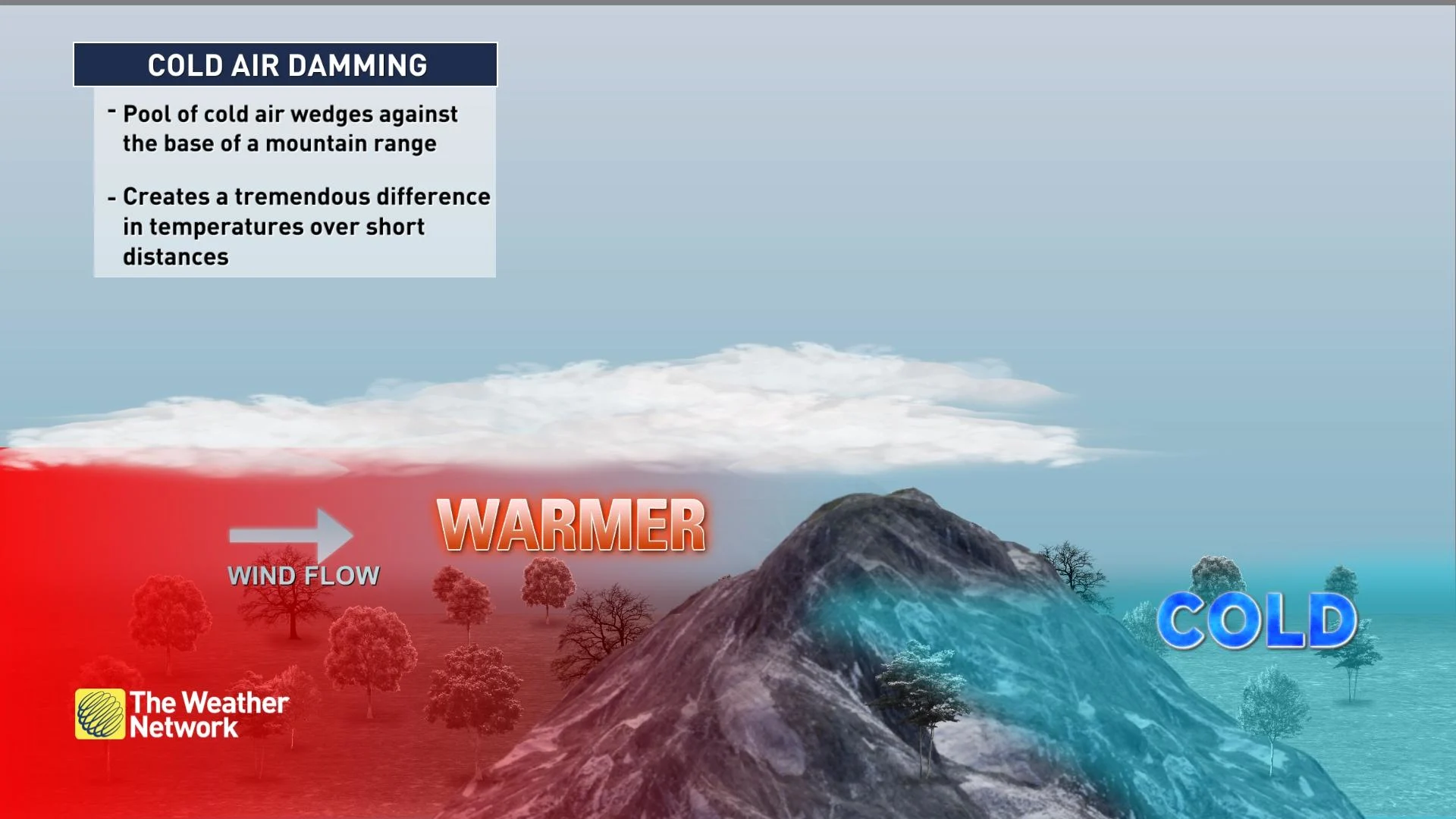
Cold air hugging the ground sometimes wedges against the base of a mountain range in a stunning phenomenon known as cold air damming. This pool of cold air can lead to astounding temperature changes over very short distances.
DON’T MISS: Canada’s cold air brings Mexico some of Earth’s most violent winds
Dense air is stubborn air
Weather is nature’s futile attempt to balance out the atmosphere. Winds blow and storms churn in the everlasting effort to strike harmony in the skies over our planet.
The planet itself can get in the way of this endless atmospheric tango. Even a formidable storm struggles to climb over a mountain range towering thousands of metres above sea level.
Cold fronts are no exception. Chilly air is dense and it hugs the ground as it crashes across the landscape.
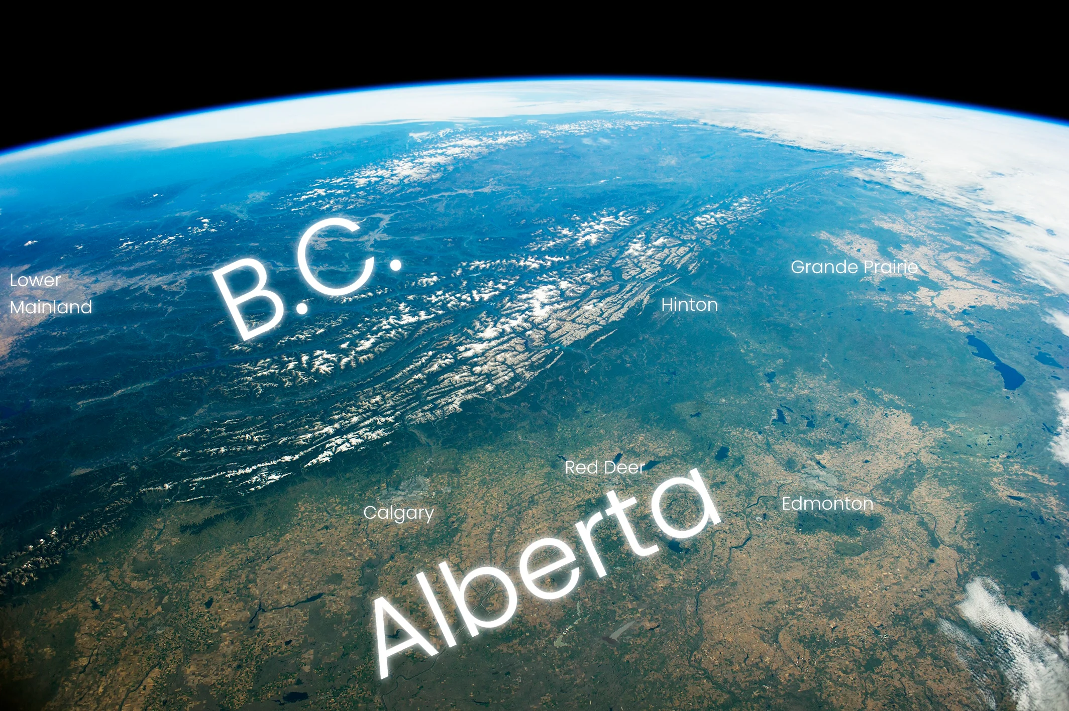
Alberta and the Rocky Mountains from space (NASA Earth Observatory)
When those frigid winds smack into the side of a mountain range, the air is often too dense to rise up and over the terrain. This process acts like a dam on a river, lending the phenomenon its name: cold air damming.
Cold air blowing against the mountains has no choice but to pool up in the foothills, much like water on a dammed river pools up to create a lake. Meteorologists sometimes call this pool of cold air a “wedge” because of its thick stature.
Days of chilly, gloomy, sometimes dangerous conditions
Communities caught beneath cold air damming can endure the chill for days at a time because of this stubborn wedge’s staying power.
Warm air blowing into a region of cold air damming may not have any effect on the cold air. The dense air is ‘heavy’ enough that warm air often can’t scour it away—it simply rises up and over the cold air instead.
MUST SEE: What is the polar vortex? How it’s responsible for dangerous cold
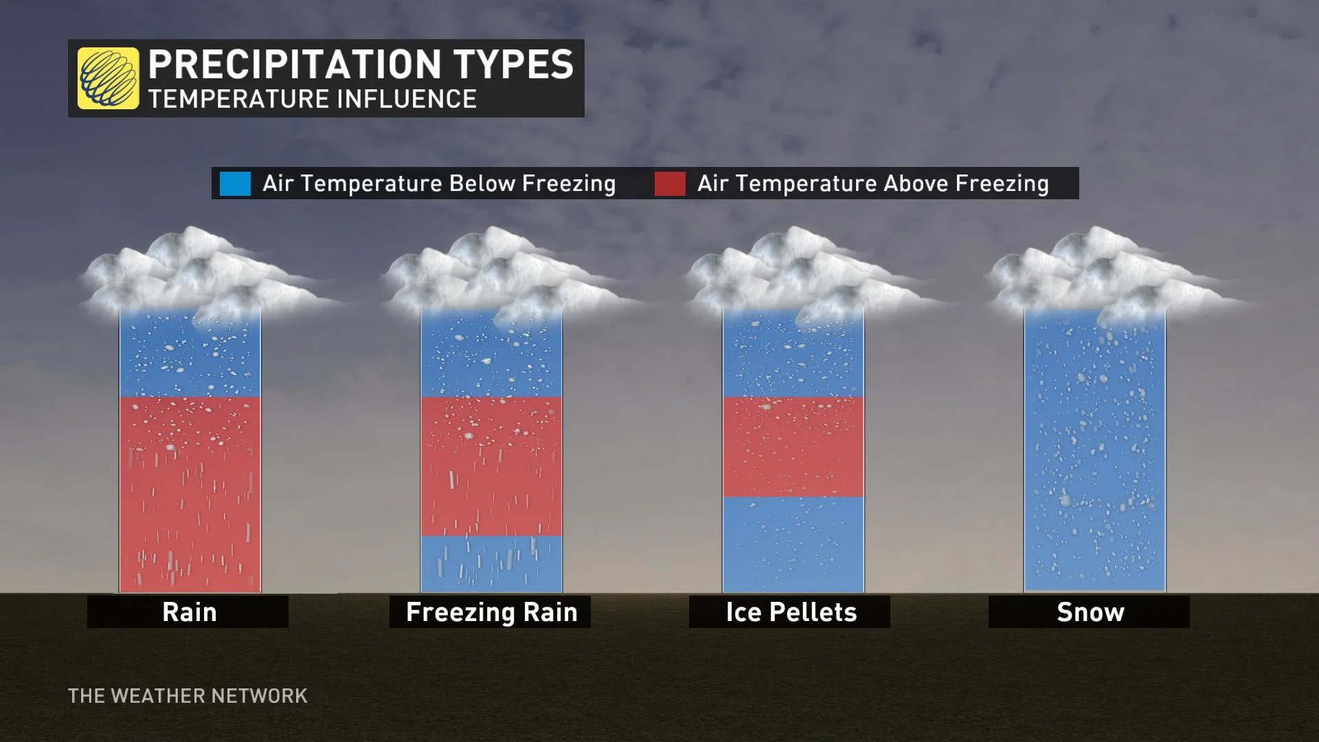
If a nearby storm blows warm, moist winds into an area of cold air damming, the process can generate thick clouds and long spells of rainy or snowy conditions. If temperatures are just right, this setup can even trigger freezing rain and ice pellets to create a long-duration ice storm.
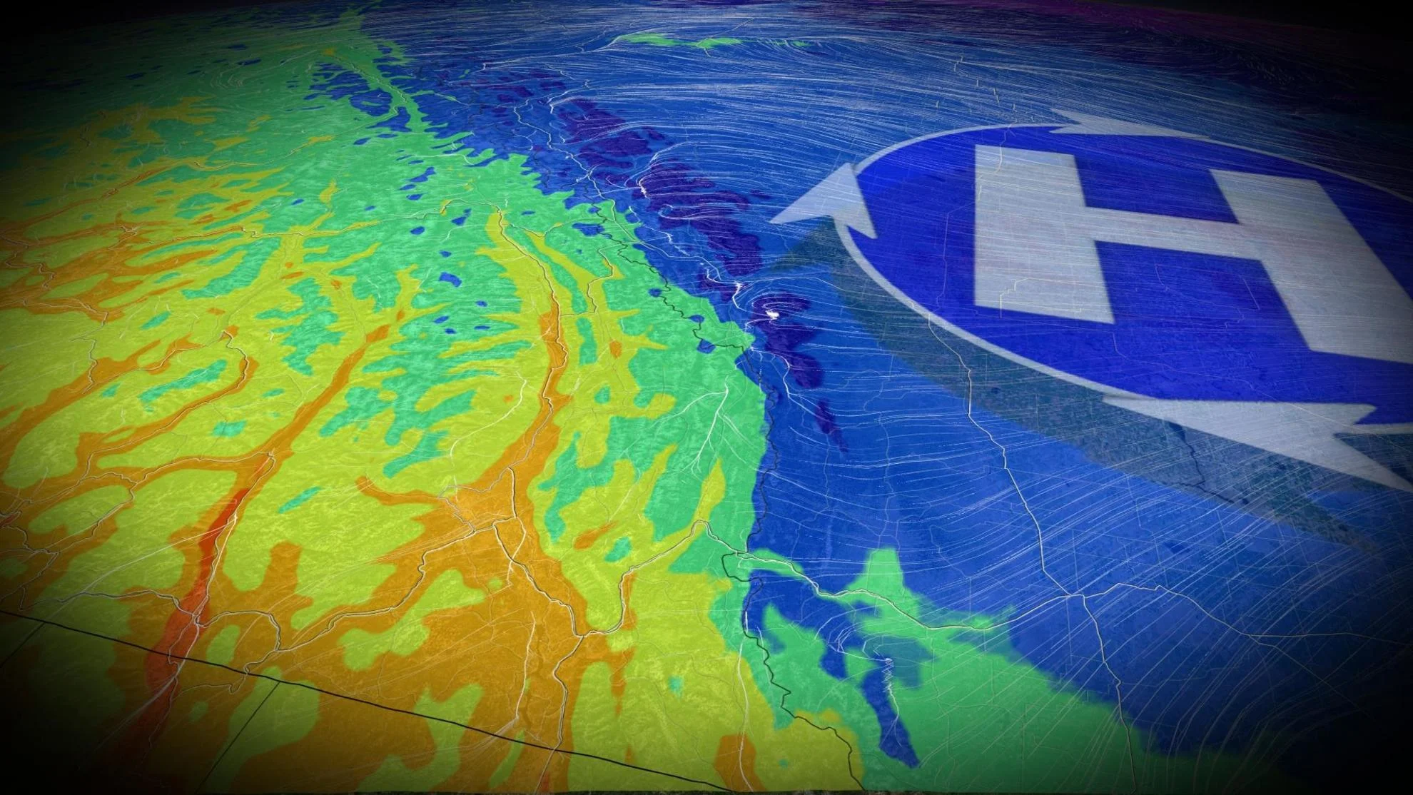
We can also see a tremendous difference in temperatures over short distances as a result of cold air damming. It’s not uncommon for readings to swing 10-20+ degrees between neighbouring towns as the wedge of cold air shifts and moves with the changing winds.
The foothills are most at risk
The most common place to see cold air damming in Canada is along the Alberta foothills. Cold fronts screaming out of the northern Prairies often smack against the eastern side of the Rockies.
Bitterly cold air arriving from the northeast can bathe areas like Calgary and Red Deer even as communities a bit higher in elevation see temperatures warmer than their low-level counterparts.
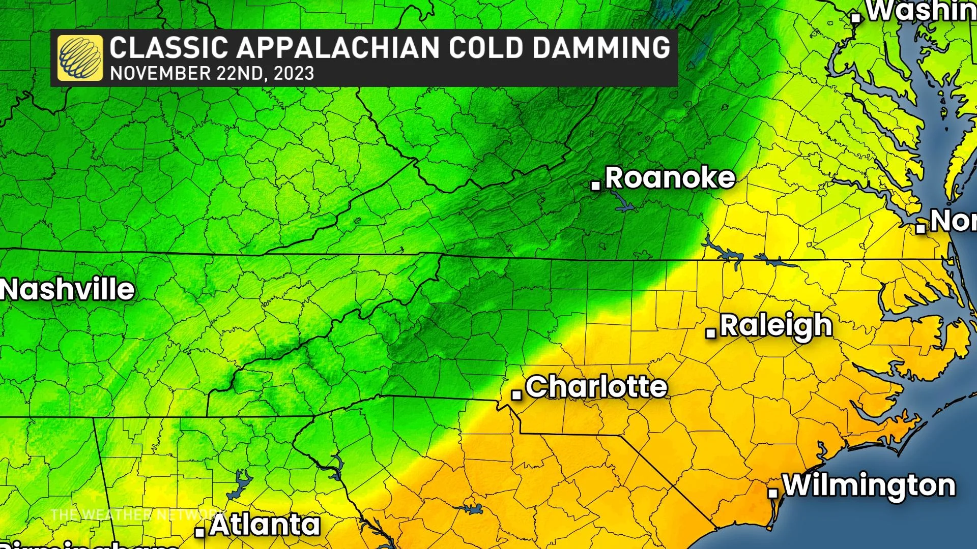
One of the most vulnerable spots for cold air damming in North America is the U.S. Mid-Atlantic region, covering communities at the foot of the Appalachian Mountains from Washington, D.C., south toward Atlanta, Georgia.
Towns in this region can see extreme temperature changes in short order. A dramatic cold air damming event in November 2023 saw the edge of the cold air fall right over Greensboro, North Carolina. As winds pushed and pulled on this wedge of chilly air, the temperature in Greensboro lurched from 7°C up to 16°C in one hour, then back down to 8°C less than an hour later.
Surges of cold air streaming south out of Canada can sweep into the Gulf of Mexico and crash into the mountains that blanket Mexico. Formidable surges of cold air pressing into southern Mexico can create vicious winds known as a Tehuantepecer, packing gusts of 100+ km/h at times.