
Sluggish storm lands a hat trick over Atlantic Canada this week
Yarmouth to Nain and everywhere in between, Atlantic Canada will see three sides of the same storm this week
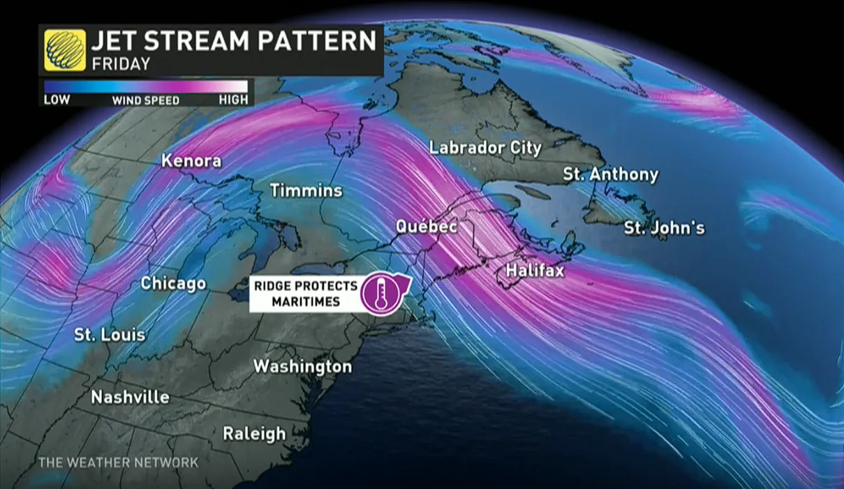
A blocking pattern in the atmosphere over Atlantic Canada will divide the region into threes this week.
Just as the NHL playoffs take centre stage, this setup is a timely hat trick landed by a storm that’s in no hurry to move along its merry way.
Parts of the region will see ample winter weather, days of gloomy rain, or an uncertain mishmash of spring-like conditions as the calendar flips to a fresh month.
DON’T MISS: Beachcomber stumbles upon fossil possibly 290 million years old
A rainy stretch for Newfoundland
As the old saying goes, “April showers bring May showers.” Well, it might not go exactly like that, but it’s what we’re dealing with across Newfoundland this week.

An upper-level low over the northwestern Atlantic Ocean is stuck meandering off the Newfoundland coast this week after getting blocked by a ridge of high pressure to its north.
That low will pinwheel over open waters to the south, feeding a steady stream moisture and chilly onshore winds over the island.

Persistent clouds, periods of rain, and below-seasonal temperatures are expected for much of Newfoundland as we close out April and head into the start of May.
It’s not a blockbuster rain by any means. Forecasters expect widespread rainfall totals of 10-20 mm, with up to 20-30 mm possible for St. John's and parts of the eastern Avalon.
This setup is likely to stick around through the end of the week before the ridge breaks and finally allows the pesky storm to pull away from the region.
Wintry weather on tap for Labrador
Winter is still hanging on farther to the north across Labrador, where moisture blowing ashore will run into Arctic air parked over the region.

While southern Labrador contends with mixed precipitation, communities along the North Coast including Nain and Hopedale could see double-digit snowfall totals by Tuesday. Accumulating snow will extend inland toward Happy Valley-Goose Bay and Churchill Falls.
The Maritimes are stuck in the doldrums
The third category doesn’t hold persistent rain like Newfoundland, or a dive back into winter like Labrador.
Mostly dry conditions will dominate the Maritimes this week as a ridge of high pressure lingers over the region. We saw burn bans in place Sunday across much of Nova Scotia as a result of the dry weather of late.
MUST SEE: What are microplastics doing to human health? Scientists work to connect dots
The story of the week will be the noticeable drop in temperatures arriving on Tuesday.
Northerly winds spiraling around that low will push below-seasonal temperatures across most of the Maritimes for the day Tuesday. Afternoon highs in the single digits are likely for Nova Scotia, New Brunswick, and Prince Edward Island.
Readings will quickly rebound heading into the end of the week, with widespread daytime readings in the teens by Thursday.
Stay with The Weather Network for the latest on conditions across Atlantic Canada.