Blazing hot with storm risk in southern Ontario
Digital Reporter
Saturday, June 11, 2016, 7:32 AM - Overnight thunderstorms heralded the start of what is expected to be a blazing hot day in southern Ontario, with a chance of more storms to come later.
![]() SUMMER 2016: Visit the Summer Forecast Guide to the Season for the 2016 Summer Forecast, Fall Weather Preview and much more
SUMMER 2016: Visit the Summer Forecast Guide to the Season for the 2016 Summer Forecast, Fall Weather Preview and much more
Daytime highs are expected to soar to the 30oC mark, or beyond, by the afternoon, with the humidity making it feel closer to 40 in some cities -- as much as 10 degrees above seasonal for areas of the southwest, and also noticeably warm in the Greater Toronto Area. Eastern Ontario is expected to remain seasonal.
"There's a large range in model forecasts for high temperatures in the GTA on Saturday, but it looks more likely that much of the GTA will be rather summer-like for several hours, likely much nicer than most people are expecting," Weather Network meteorologist Dr. Doug Gillham says.
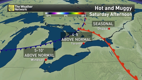
Temperatures will fall considerably into Sunday to the low 20s, ramping up to the mid 20s slowly during the week.
As for Saturday, the intense heat would normally portend a higher risk of severe thunderstorms, but forecasters say that risk has considerably lessened in the latest models.
By the time a cold front to the north sweeps through the region, humidity levels will be too low for storms to trigger, and there is expected to be less sheer from lake breezes.

This is not to say there will be no thunderstorms, just that the probability is low, and such storms as do fire up will be likelier in the extreme southwest in the Windsor area.
"We're not ruling it out, but the signature looks less prominent," Weather Network meteorologist Brett Soderholm says.