All of southwest B.C. under flood watch as 3rd consecutive storm rolls through
THE LATEST:
Up to 100 millimetres of rain is expected in the flood-battered Fraser Valley, with a snowfall advisory also in place for parts of central B.C.
Meteorologists have confirmed that numerous rainfall records were broken provincewide in November.
Highway 99 has reopened between Lillooet and Pemberton, but only for essential traffic. Many highways under travel advisory in the province. For a full list of closures, see here.
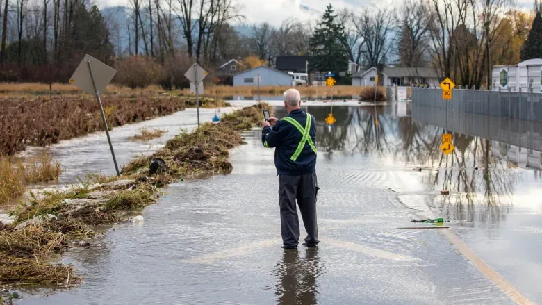
Evacuation orders remain in effect for properties near waterways in the Fraser Valley, the Thompson-Nicola Regional District, and the Sea to Sky region. For more on evacuation alerts and orders, see here.
A flood warning is in place for the Coldwater, Nicola, Tulameen, Similkameen,Spius, Coquihalla, Chilliwack and Sumas Rivers, as well as for Lower Fraser River tributaries and for the Sumas Prairie. For all flood warnings and advisories, see here.
The last of three major storms is pounding southwest B.C. with heavy rain as flood-ravaged communities brace for potential evacuations and damage.
Much of the province is under either a flood watch or flood warning advisory. A flood watch means river levels are rising and may exceed their banks and flood adjacent areas. A flood warning means river levels have exceeded or will exceed their banks, and nearby areas will flood as a result.
Much of Southwest B.C. is currently under flood warning, with flood-soaked regions like the Fraser Valley and the Nicola Valley east of Vancouver set to receive up to 100 millimetres of rain, while snow is also expected at higher elevations.
The impact from the rain is expected to be worse due to extensive damage from the two previous storms. The biggest, which struck the province from Nov. 13 to 15, led to landslides and rainfall records being broken, while another two before and during the weekend led to renewed evacuation orders and highway closures.
B.C. Safety Minister Mike Farnworth, in a Wednesday morning news conference, stressed that people need to be prepared if they live in a flood zone and that they should stay off roads in affected areas unless absolutely necessary.
"I want to make it clear to everyone this storm is not yet over," he said.
Evacuation orders remain in place for hundreds of properties in southwest B.C. The current storm system affecting the province hit the Central Coast first before travelling south, leading to more evacuation orders in areas north of the Fraser Valley region and Metro Vancouver.
This includes the communities of Hope, Mission, and Hatzic in the eastern Fraser Valley. Some residents of Maple Ridge, just east of Vancouver, had warnings delivered to them due to potential floods.
Hundreds of residents also remain away from their homes in B.C.'s Interior, including in Princeton and Merritt.
Residents forced to flee floodwaters mid-month also remain away from their homes in B.C.'s Interior, including in Princeton and Merritt.
Transport Canada has temporarily restricted non-essential marine traffic on B.C. waterways in certain flooded areas, including sections of the Fraser, Coldwater and Similkameen rivers.
Nearly all of the province is at a high or extreme risk of avalanche, with the greatest dangers in places like the Sea to Sky region, north of Vancouver, the northwest coast and the northern Rockies.
Up to 150 millimetres of rainfall is forecast for parts of Vancouver Island on Wednesday, and nearly the entire Island is under a flood watch.
A flood watch is also in effect for the Fraser, Tulameen, Coldwater, Similkameen, Coquihalla and Sumas rivers. A flood warning means river levels have exceeded or will exceed their banks, and nearby areas will flood as a result. A flood watch means river levels are rising and may spill their banks.
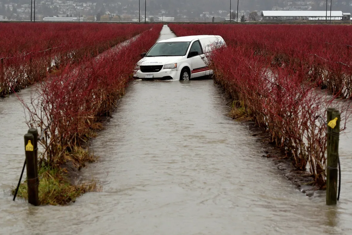
A restoration company vehicle sits in a flooded field after rainstorms in Abbotsford, in the Fraser Valley southeast of Vancouver. Areas up the valley, such as Hope and Mission, have also seen major flood events leading to evacuation orders (Jennifer Gauthier/Reuters)
HIGHWAY CLOSURES AND CHOKED SUPPLY CHAIN
On Tuesday, Highway 99 between Pemberton and Lillooet was closed until further notice due to weather conditions. The stretch saw a mudslide that left four people dead and one missing.
Numerous other highways remain closed or under travel advisory due to the impact of previous floods and mudslides.
The stretch of the Trans-Canada Highway (Highway 1) between Abbotsford and Chilliwack, crucial for connecting Metro Vancouver and the rest of the province, remains closed.
There is also a travel advisory for Highway 20 in the Bella Coola Valley area on the Central Coast.
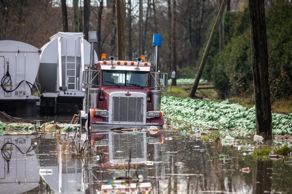
A flooded semi-truck is pictured near sandbags in Abbotsford. Supply chain issues stemming from the floods continue to affect British Columbians, with food deliveries delayed and fuel rationing in place. (Ben Nelms/CBC)
Canadian National said on Monday that it had stopped some of its service along the southern B.C. freight corridor because the rain caused increased debris, washouts and landslides.
CN diverted some rail traffic to the Port of Prince Rupert, but both northbound and eastbound traffic to and from Vancouver were still affected.
Fuel rationing is also set to remain in place in B.C. until at least Dec. 14.
COMMUNITY SPIRIT IN ABBOTSFORD
In the city of Abbotsford, southeast of Vancouver, which has been particularly hard hit by flooding, numerous volunteers were using Facebook groups to coordinate and help those in need.
Kulwant Gill, a volunteer who spent her lunch break filling sandbags at the city's Albert Dyck Park, said many residents were "trying to do their part" as human beings during the natural disaster.
Abbotsford Mayor Henry Braun said Tuesday that flood modelling showed water levels were stabilizing, and said he was "confident" the city had done all it could to prepare for the last weather event this week.
This article was originally published for CBC News, with files from Joel Ballard and The Canadian Press.


