Arctic melt season ends with largest sea ice minimum since 2014

While a welcome sight compared to the past few years, this is not a significant recovery for the Arctic.
Arctic sea ice has been getting dangerously close to setting a new record summer low over the past few years. Yet, as the summer melt season wraps up for 2021, the ice extent looks to be the largest since 2014. While having more sea ice across the Arctic is a good thing, this increase is most likely just a short-lived uptick in an otherwise troubling trajectory.
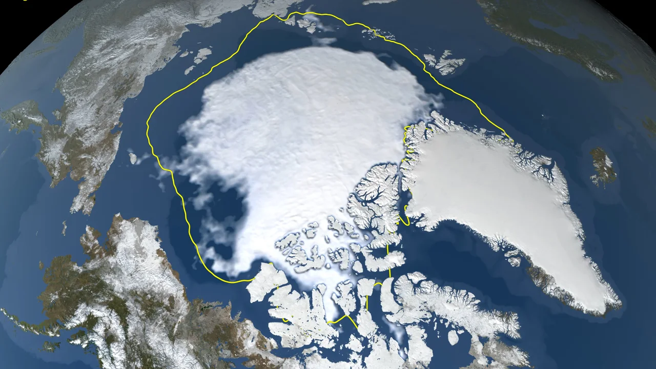
As of September 16, sea ice across the Arctic Ocean appears to have reached its minimum extent for the year.
According to NASA and the National Snow and Ice Data Center (NSIDC), this year's minimum covers an area of 4.72 million square kilometres. That's nearly a million square kilometres larger than the 2020 minimum (currently the 2nd lowest on record) and it's nearly half a million sq km larger than the minimum in 2019.
Overall, it ranks as the 12th lowest minimum extent since record-keeping began in 1978, and it is the largest minimum extent seen since 2014.
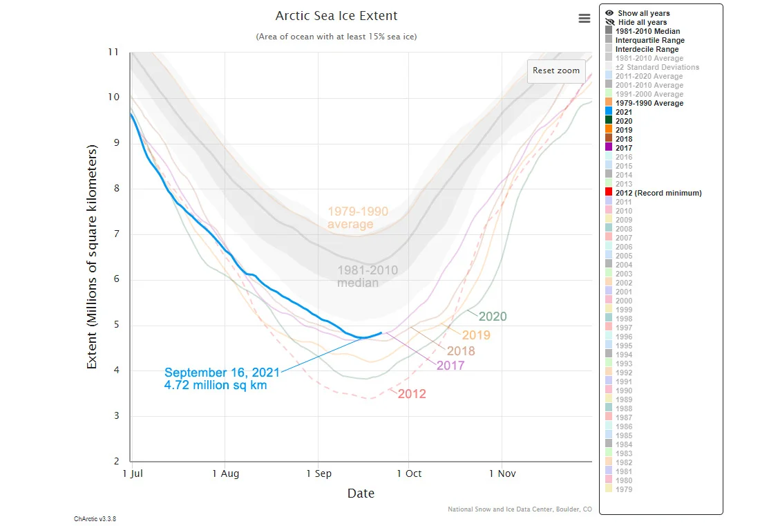
This graph of Arctic sea ice shows the September 16, 2021 minimum extent in context with the past four years and the 2012 record low minimum. Credit: NSIDC/Scott Sutherland
Each year, sea ice spreads across the Arctic Ocean during the winter and then it melts away during the summer. It's maximum winter extent is typically seen in March, while it reaches its minimum extent usually sometime in September. The exact size of the minimum extent varies from year-to-year. However, under the influence of climate change we have been seeing these summer minimums getting smaller over time.
In 2012, satellites recorded the lowest minimum extent on record. At the time, it covered just just 3.39 million square kilometres of the Arctic Ocean. That's less than half the size it used to be, on average, just 30–40 years ago.
According to the NSIDC, "The last 15 years are the lowest 15 sea ice extents in the satellite record."
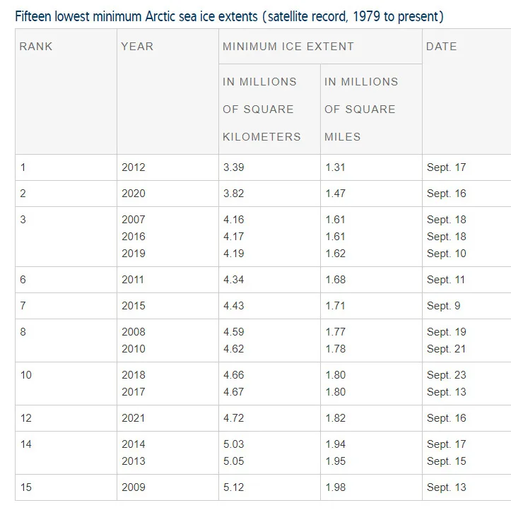
This table lists the 15 smallest minimum extents that have occurred since 1979. Any values that are within 40,000 sq km of each other are considered to be ties. The 2021 minimum extent is ranked as the 12th smallest. Credit: NSIDC
This year's minimum extent being larger than those of the past few years is, by no means, a sign of recovery for the Arctic. The more sea ice there is at the end of the melt season, the less open ocean surface there is to absorb sunlight. Relatedly, the increase in sea ice seen this year is only new, first-year ice, that formed since the near-record melt of 2020. Multi-year ice, which is much more resilient, is still disappearing at an alarming rate. The more multi-year ice that we lose, the closer we come to seeing years where the Arctic Ocean is completely ice-free during the summer.
As the NSIDC wrote on September 22: "Multiyear ice extent is one of the lowest on record. First-year-ice coverage increased dramatically since last year, jumping from 1.58 million square kilometres (610,000 square miles) to 2.71 million square kilometres (1.05 million square miles). The increase in total extent from last year's minimum to this year's is hence comprised of first-year ice."
"The overall downward trend in the minimum extent from 1979 to 2021 is 13.0 percent per decade relative to the 1981 to 2010 average. The loss of sea ice is about 80,600 square kilometers (31,100 square miles) per year, equivalent to losing the size of the state of South Carolina or the country of Austria annually."