Powerful winds bring down trees, fuel blizzard conditions, dangerous travel

A deep low-pressure system resulted in a swathe of howling winds across much of the southern Prairies Wednesday, well in excess of 100 km/h in dozens of communities. The next target was Saskatchewan, where the strong gusts combined to make for dangerous travel due to blizzard conditions. Though the winds will die down to below warning criteria by Thursday morning, a blustery day awaits, ahead of a cooldown by the weekend.
WEATHER HIGHLIGHTS:
Winds die down below warning criteria by Thursday morning, though still blustery
Major pattern reversal on the way, which features much colder weather for Western Canada
WEDNESDAY NIGHT INTO THURSDAY: SWATH OF SNOW, POWERFUL WINDS BRING BLIZZARD CONDITIONS
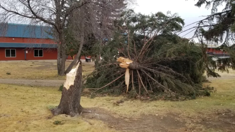
The truck-toppling winds that hit southern Alberta on Tuesday afternoon were just a precursor to the potent system that brought extreme winds to much of the Prairies Wednesday, leaving being serious damage ahead of a night of difficult travel.
The epic winds slammed Alberta, with gusts exceeding 100 km/h in dozens of communities. The strongest was a gust of 137 km/h in the village of Barnwell, west of Taber, which was the strongest ever recorded any time in the month of January for that location and the equivalent of a Category 1 hurricane gust.
Eight other communities reported all-time January record gusts, and widespread wind damage was reported to trees and buildings.
The winds weren't done with the Prairie region by day's end Wednesday, and as bad as travel was in Alberta earlier in the day, a harder ordeal awaited travellers in areas with snow as well.
Some 20-30 cm is possible for some northern parts of Saskatchewan, but even in places with more modest expected amounts, such as central Alberta and much of Saskatchewan, the strong winds were set to make for dangerous blizzard conditions through the night.
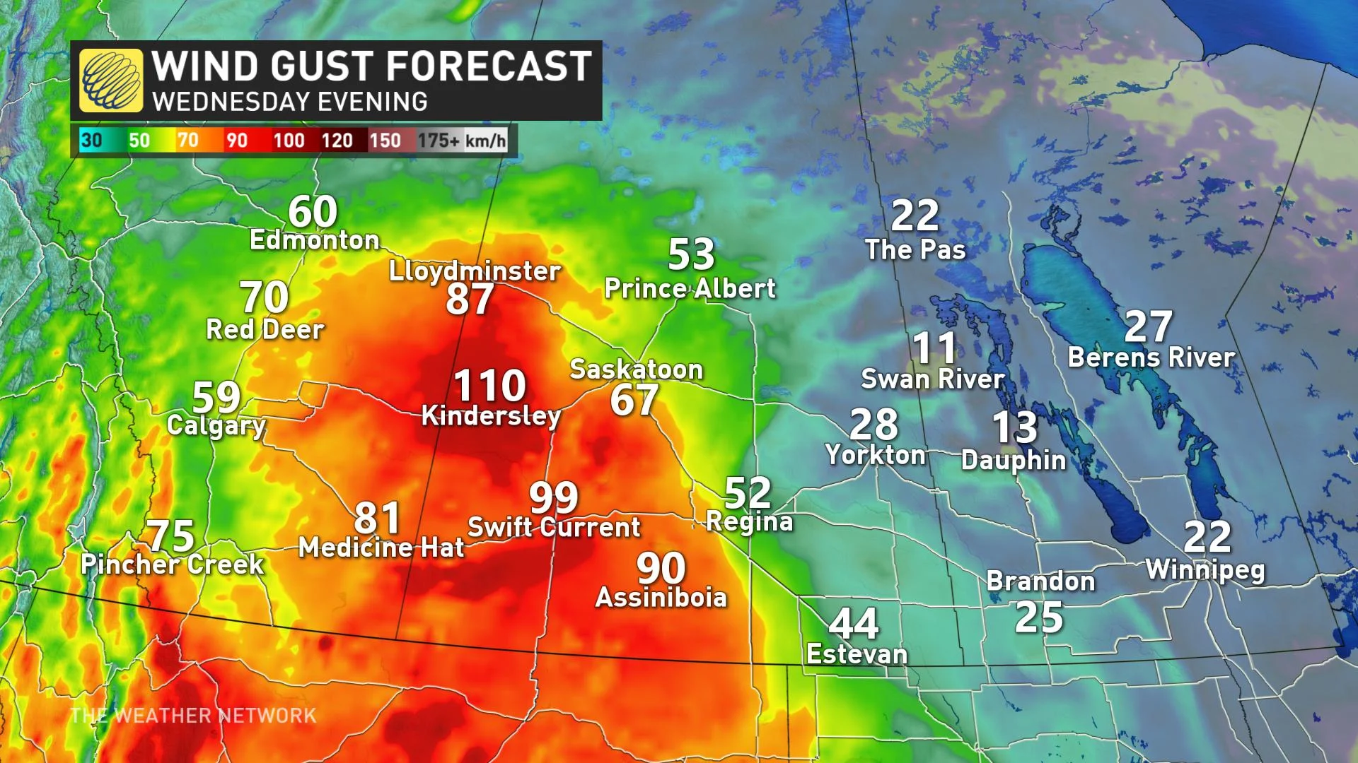
Some localized areas in southern Saskatchewan may see hurricane force gusts of 120+ km/h. This includes major transportation corridors, making for dangerous travel conditions once again.
In addition to the strong winds and snow, the system will include a risk for some freezing rain across central Alberta and Saskatchewan.
WATCH BELOW: DAMAGING EFFECTS OF THESE STRONG WINDS
COLDER AIR ACCOMPANIES A PATTERN REVERSAL
While the strong winds will subside below warning criteria by Thursday morning, much of Thursday will still remain blustery.
Temperatures will drop back to near seasonal across southern Manitoba for the weekend, with Arctic air set to plunge south into western parts of the Prairies by Wednesday next week, before gradually spreading eastwards.
"Expect frigid weather for the final week of January and a much colder pattern is expected to dominate through February," says Weather Network meteorologist Dr. Doug Gillham.
UPDATED: Don't write off winter, Canada. Updated January outlook signals major changes


