
Canada's 2020/21 Winter Sneak Peek: 'La Niña kicking into high gear'

A preliminary look ahead to winter
A developing La Niña will be one of the key drivers of our winter pattern. However, while La Niña winters tend to have some common characteristics, there is a lot of variability in exactly what this could mean for each part of Canada, and there are other variables that contribute to a winter pattern.
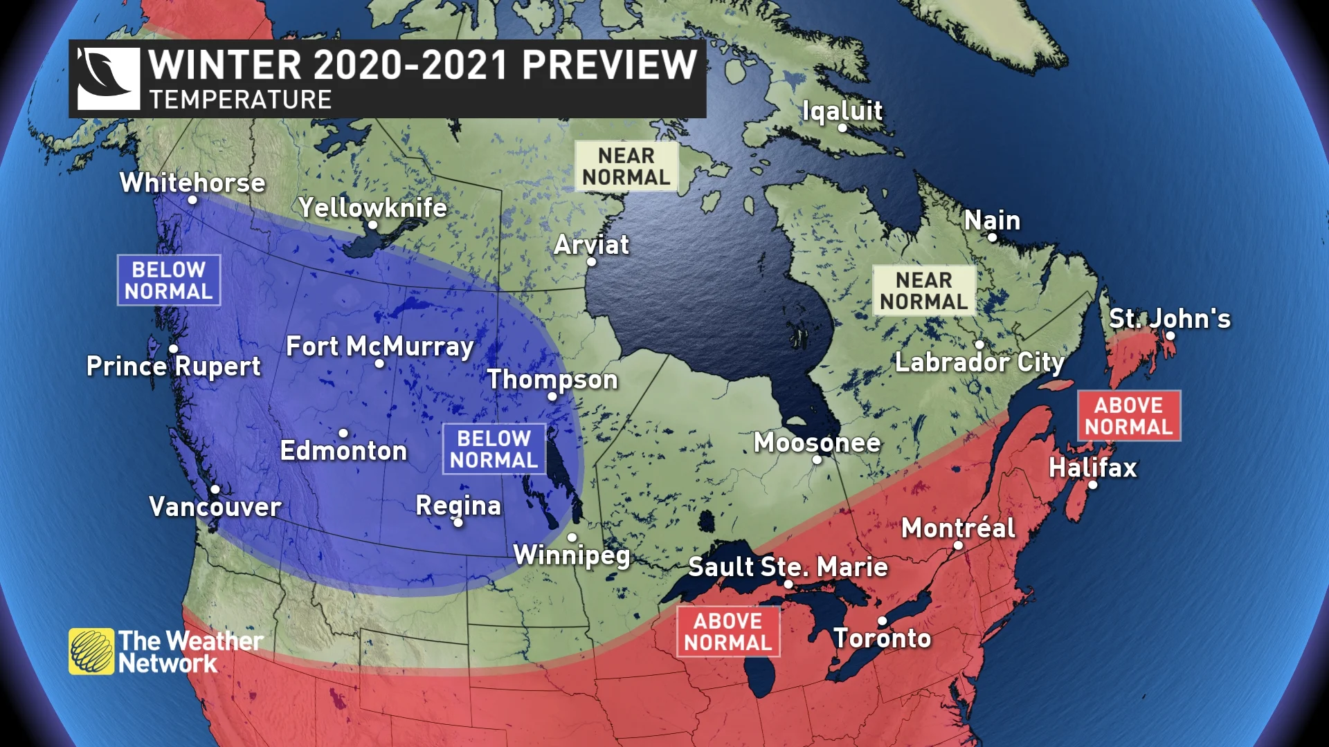
La Niña winters do tend to be colder and snowier across Western Canada, and at this point we expect that we will see that typical pattern again this winter. For British Columbia and a large part of the Prairies, we expect colder than normal temperatures with an abundance of snow across the region, including the ski areas.
From the Great Lakes to Atlantic Canada, we expect that temperatures for the winter as a whole will be warmer than normal. This should mean fewer and shorter outbreaks of severe cold and below normal ice coverage on the Great Lakes.
Visit our Complete Guide to Fall 2020 for an in depth look at the Fall Forecast, tips to plan for it and a sneak peek at the winter ahead
However, keep in mind that a mild pattern does not rule out high-impact snow and ice storms. During a Canadian winter, temperatures can be above seasonal and still cold enough for substantial snow and ice.
In fact, when we look back in history at previous La Niña winters across Eastern Canada, we see that they can be memorable either for their lack of winter weather or for their abundance of winter weather. Here is why.
During La Niña winters we often have a strong ridge in the jet stream over the southeastern United States, which results in warm conditions across this region. Some years that warm pattern expands north and takes over across Eastern Canada, and winter weather can be absent for weeks on end.
WATCH BELOW: CANADA'S 2020 FALL FORECAST
RELATED: Watch for these amazing night sky sights in the season to come
However, across the battle zone between the cold pattern across Western Canada and the warmer pattern across the southeastern U.S., we often see a very active storm track. When that storm track stays to the north, weather systems usually bring rain to the region. But at times the storm track shifts to the south, and when that happens, we can often see a parade of winter storms with an abundance of snow and ice. This can even happen in a winter that is warmer than normal.
Unfortunately, it is still too early to know exactly where that storm track will set up and it is likely that it will vary in its position through the winter. Between now and the release of our final winter forecast at the end of November, we will fine-tune the forecast and seek to get a better handle on where the dominant storm track will be. That will be the key to whether the upcoming winter is simply mild or whether it turns messy and wild.


