Welcome to spring, Canada! Your next three months of weather, here

Winter has just officially come to an end, but most of Canada has already been treated to spring-like temperatures. Will this mild pattern continue? Please read on as we take a look at what you can expect across Canada during the next few months.
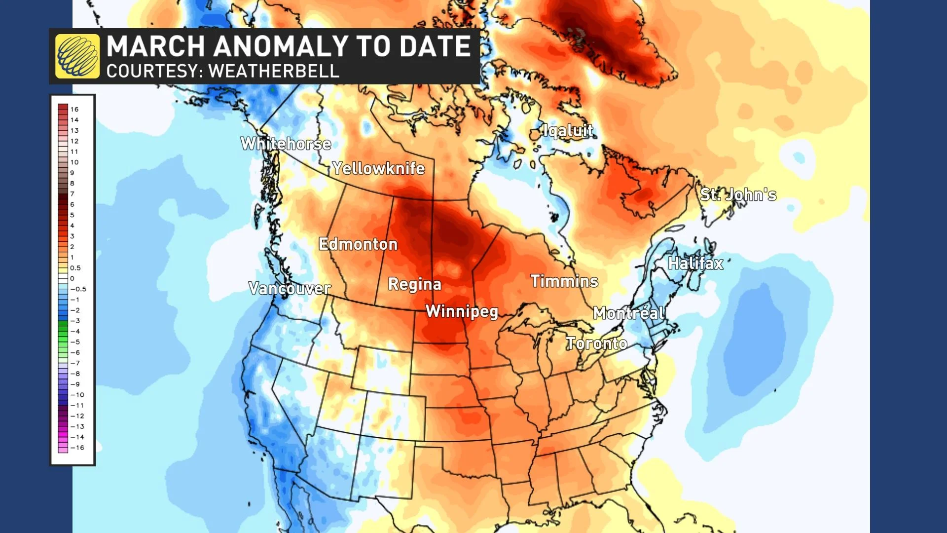
After a frigid February across Central Canada, March has featured a dramatic pattern reversal with above normal temperatures for most of the country. A notable exception has been the region that had one of warmest winters on record -- across the Maritimes where March has been colder than normal so far. The South Coast of B.C. and the Yukon have also been cooler than normal.
Here is the temperature anomaly map for March so far, with the various shades of orange and red highlighting the widespread above normal temperatures.
Visit our Complete Guide to Spring 2021 for tips to plan for everything ahead!
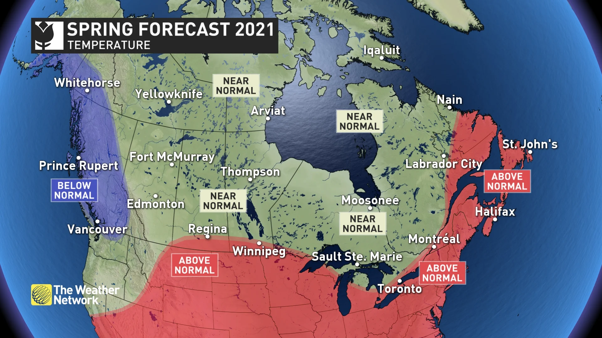
NATIONAL TEMPERATURE PATTERN
As we look ahead at the rest of March, April and May, it is important to remember that spring is notorious for its changeable temperatures, and this year will be no exception.
However, for most of Canada east of the Rockies, these alternating periods of warm and cooler weather will come close to offsetting each other or tip to the warm side of normal.
This means that the upcoming spring season should be warmer than many of the springs in recent memory. However, we expect that temperatures will tip to the cool side of normal across much of B.C. and the southern Yukon.
NATIONAL PRECIPITATION PATTERN
We expect that most of Canada will see near normal precipitation during spring, but there are a couple of regions with the potential for above normal precipitation – much of British Columbia and from the northern Great Lakes to central Quebec.
For B.C., we expect that a wet pattern will continue through April, and then the province should trend to a more seasonal pattern during May. For Ontario and Quebec, we don’t expect more than the typical number of rainy days, but a few soggy systems should tip the final numbers to the wet side of normal for parts of the region.
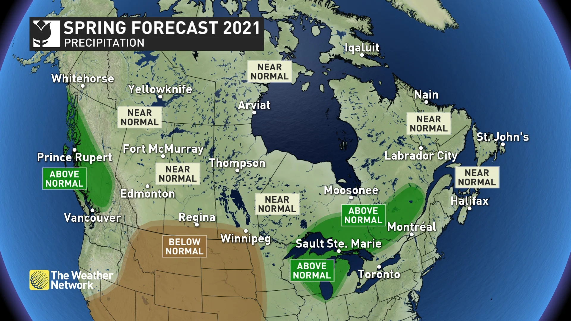
We are very concerned about the increasingly dry conditions across the southern Prairies. This region had a very dry winter and soil moisture is well below normal. While the models, as well as our research into historical patterns, gives us reason to be cautiously optimistic that beneficial rains will return to the region during spring, we are concerned that the dry spring pattern south of the border could end up including parts of the southern Prairies.
Despite the expectation of near normal or above normal precipitation for large parts of Canada, the overall threat for spring flooding is much lower this year. Most of the regions where spring flooding is an annual concern currently have well below normal snowpack from the winter. The one exception is across the alpine regions of B.C. and Alberta where the snowpack is above normal, and we will have to closely watch the risk for flooding in these areas if we see a period of very warm weather later in the season.
Below is a more detailed look at the regional forecast for the months of March, April and May.
BRITISH COLUMBIA
Spring usually comes first to this part of Canada and that will still be the case this year, but overall we expect that our progress through the season will be slower than what we often see across the province. This will allow for outstanding spring skiing with an above normal snowpack already in place. A delay in the arrival of consistently warm weather will allow the ski season to extend deeper into the spring. However, this could also bring a heightened risk for spring flooding when warm weather finally does arrive.
At this point, it does not look like we will see an early start to the wildfire season. While it is too early to discuss the summer wildfire season, a cooler and wet spring should at least delay the start of the fire season.
WATCH BELOW: LINGERING COLD IS GREAT NEWS FOR SPRING SKIING
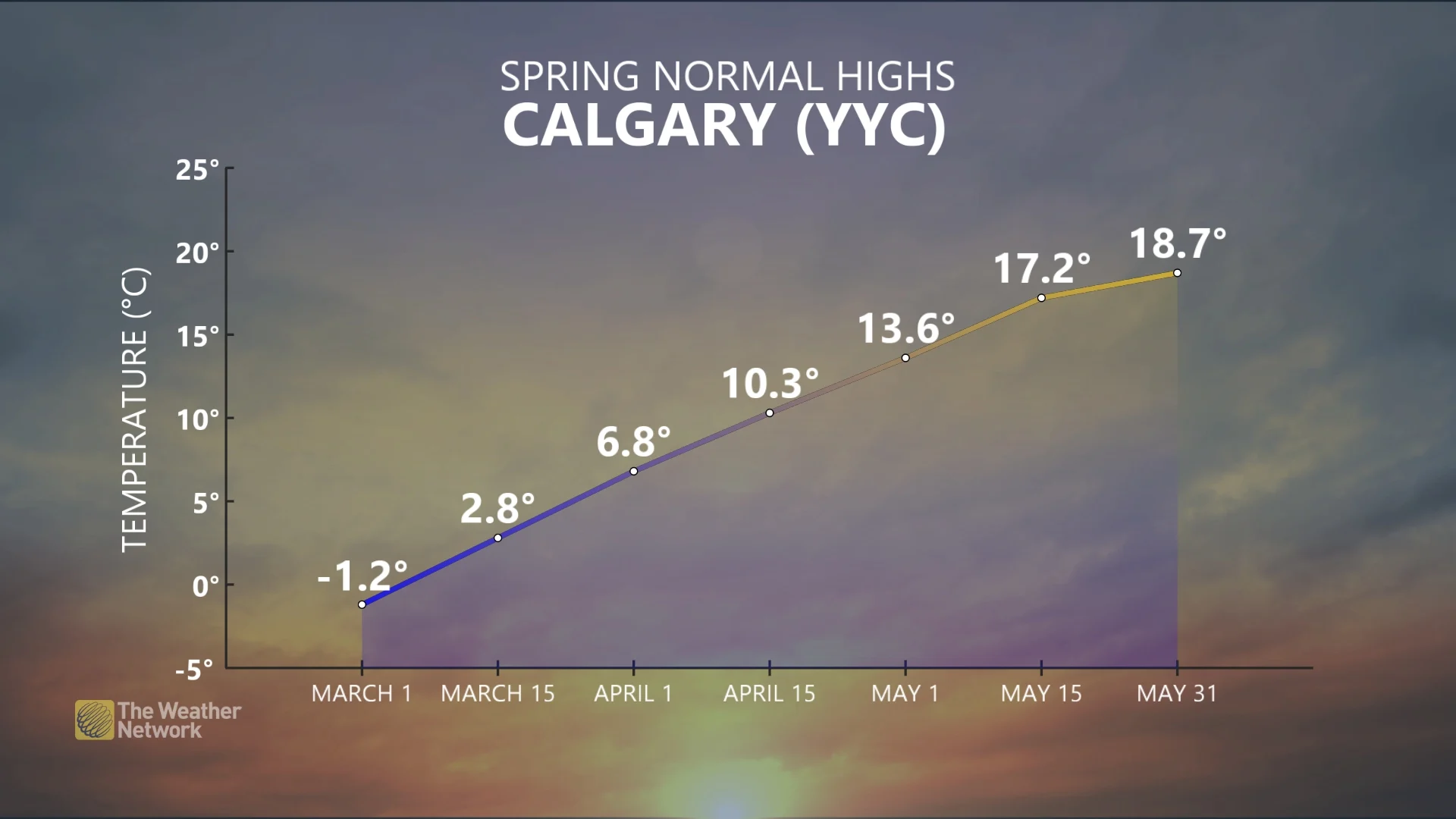
ALBERTA
March has featured an abrupt transition from frigid winter weather to mid-spring like weather. However, as we head into the heart of the spring season (April and May) we expect a more typical spring pattern with back-and-forth temperature swings that should come close to offsetting each other. Residents of this region also know all too well that high-impact winter weather should be expected on occasion throughout the spring season.
Near normal precipitation is expected for most of Alberta, but southernmost parts of the province are at risk to tip to the dry side of normal and we are concerned about summer drought having an impact on agriculture across southern areas.
With above normal snowpack in place across the Rockies, we will have to closely monitor the risk for spring flooding if we do get a period of very warm weather later in the season.
SASKATCHEWAN AND MANITOBA
March has delivered a dramatically warmer pattern than February across Saskatchewan and Manitoba with extended periods of much warmer than normal temperatures. However, as we head into the heart of the spring season (April and May) we expect a more typical spring pattern with back-and-forth temperature swings that should come close to offsetting each other. Residents of this region also know all too well that high impact winter weather should be expected on occasion throughout the spring season.
The well below normal snowpack across the region means a greatly reduced risk for spring flooding. However, after a very dry winter across southern parts of the region, we are increasingly concerned about drought conditions as we head into the growing season. While the models and our research into historical patterns provide some hope that we will see beneficial rains during the spring, we are concerned that the widespread dry spring pattern south of the border will end up including parts of the southern Prairies.
Our very preliminary look ahead to summer is concerning for agricultural interests across southern parts of the region as a hot and dry summer is expected, especially south of Hwy 1.
ONTARIO
After a warm March, we expect that most of the province will see back-and-forth temperature swings during April and May that will come close to offsetting each other. However, it appears more likely that we will tip to the warm side of normal rather than colder than normal. Southernmost areas have the best chance of ending up with a warmer than normal spring. This should give us a warmer spring than many springs in recent memory.
While localized spring flooding could still occur, the risk for widespread flooding is lower than normal this spring due to the below normal snowpack across much of the province as we start spring. Above normal precipitation is expected for parts of central and northern Ontario, but we do not expect more than the typical number of rainy days.
WATCH BELOW: ABOVE NORMAL PRECIPITATION DOES NOT MEAN A WASHOUT OF A SPRING
QUEBEC
While March has delivered periods of chilly winter weather, very warm weather during the second half of the month will tip the final numbers to the warm side of normal. During April and May we expect that back-and-forth temperature swings will come close to offsetting each other, but southern and eastern parts of the province should end up warmer than normal.
While localized spring flooding could still occur, the risk for widespread flooding is lower than normal this spring due to below normal snowpack across much of Quebec. Above normal precipitation is expected for southern parts of Quebec, but we do not expect more than the typical number of rainy days.
WATCH BELOW: MORE RECORD-BREAKING WEATHER ACROSS QUEBEC THIS SPRING?
NEW BRUNSWICK, NOVA SCOTIA, PRINCE EDWARD ISLAND, AND NEWFOUNDLAND & LABRADOR
Back-and-forth temperatures swings are expected to tip to the warm side normal across Atlantic Canada, but we will still see the inevitable periods of colder weather that will test our patience as we wait for consistently warm weather. Also, the milder forecast certainly does not rule out late winter-like storms.
Near normal precipitation is expected, but we have a lower than typical risk for widespread spring flooding due to the below normal snowpack across the region.
WATCH BELOW: WILL THE MILD TEMPERATURES CONTINUE INTO SPRING?
YUKON, NUNAVUT, AND NORTHWEST TERRITORIES
Colder than normal spring temperatures are expected for southern Yukon, including Whitehorse, but near normal temperatures and precipitation are expected across the remainder of the region.


