Canada takes centre stage in a dramatic month of global weather disasters

July in Canada started on the heels of a historic heat wave and ended with the country blanketed in wildfire smoke. The calamities didn’t end there. This was a rough month for weather disasters far and wide.
July was a month to remember here in Canada and around the world. From fires and floods to extreme heat and a barrage of tornadoes, the remarkable pace of disasters over the past few weeks left entire communities devastated. Here’s a look back at some of the intense weather events we witnessed in July.
JULY BEGAN ON THE HEELS OF A HISTORIC HEAT WAVE
Extreme heat is a slow-motion disaster. Raging floods and imposing tornadoes illustrate their power with gripping visuals, but a long spell of overwhelming heat exacts a silent toll. Each hot afternoon bleeds into a stifling night that provides no relief for those who can’t escape the sweltering air’s clutch.
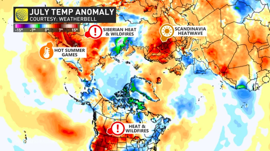
Western Canada’s long tangle with the heat began in late June with a mammoth ridge of high pressure that built over western North America. Dozens of communities in British Columbia, Washington, and Oregon shattered their all-time high temperature records.
Day after day of unprecedented heat resulted in hundreds, if not thousands, of deaths among those who suffered heat-related illnesses. The B.C. Coroners Service reported on July 26 that the heat may have claimed more than 800 lives in the province.
The high-impact, long-duration heat event that began in late June continued through the rest of July. Excessive temperatures started out the month in B.C. before shifting east and roasting the Prairies for weeks on end. Some towns on the southern Prairies saw above-seasonal temperatures on all but a handful of days in July.
NO COMMUNITY HIT HARDER THAN LYTTON, B.C.
Lytton, B.C., felt the heat and its tragic aftermath harder than anyone else in the country. The small town along the Fraser River in south-central B.C. broke Canada’s all-time hottest temperature record three days in a row in the closing days of June.
The thermometer in Lytton read 49.6°C on June 29, setting a new Canadian high temperature record. This new record is several degrees hotter than the hottest temperature ever recorded in the desert getaway of Las Vegas, Nevada.
By June 30, a fast-moving wildfire razed 90 per cent of all buildings in Lytton.
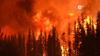
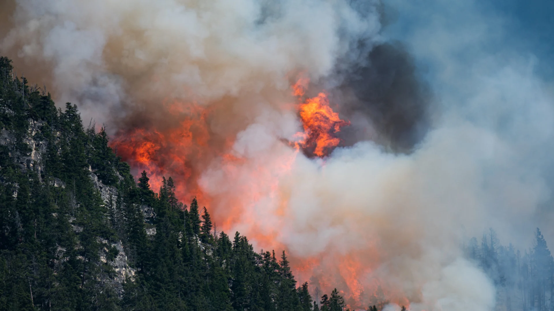
JUNE’S EXTREME HEAT HELPED FUEL JULY’S EXTENSIVE FIRES
The devastating blaze that tore through Lytton at the culmination of the West’s unparalleled heat wave was just one of hundreds of fires that burned across Interior B.C., the Prairies, and the U.S. Northwest in July.
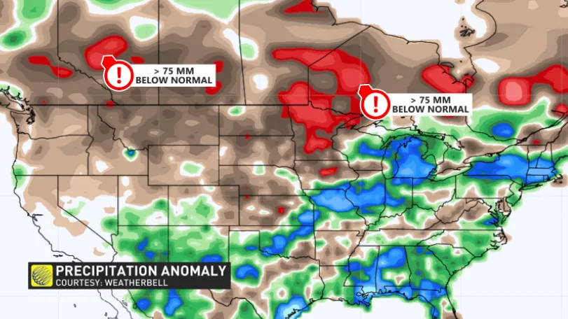
July began with a widespread drought that stretched from Vancouver Island all the way to northwestern Ontario. The situation was particularly dire in Interior B.C. and the southern Prairies. Southern Manitoba maxed out the Canadian Drought Monitor’s scale for measuring drought conditions.
The heat made a bad situation even worse. Several days and nights of unprecedented warmth, followed by weeks of above-seasonal temperatures and little precipitation, intensified the drought and made a tinderbox of vegetation across the region.
By the end of July, more than 1,200 fires had been reported in B.C. alone, with nearly 400,000 hectares of land burned in the province. Even more fires were reported throughout the Prairies and northwestern Ontario, including a large complex of fires northeast of Winnipeg. Several fires near Red Lake, Ontario, each consumed tens of thousands of hectares of land.
CHOKING WILDFIRE SMOKE SPREAD EAST
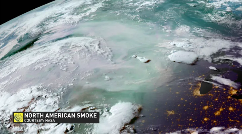
Hundreds of fires burning simultaneously across B.C., the U.S. Northwest, and the Prairies sent a prolific amount of smoke pouring into the atmosphere. The jet stream helped spread these plumes of smoke thousands of kilometres downwind from the blazes, reaching as far as Atlantic Canada to the east and Texas and North Carolina to the south.
Not only did the smoke obscure the midsummer sun, but winds pushed much of that smoke down to the surface and resulted in long periods of dangerous air quality for much of the country.
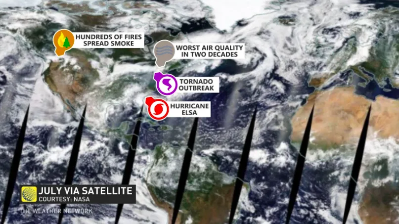
Southern Ontario endured several days of thick smoke in mid-July, causing the region’s air quality to plummet to its worst level in two decades. Air quality issues reached deep into the United States, as well, where New York City experienced exceptionally poor air quality by modern standards.
Canada and the U.S. weren’t the only areas struggling with fires and dense smoke in July. A similar weather pattern played out in northern Russia, where a historic wildfire season in Siberia has led to a thick pall of smoke blanketing much of eastern Asia.
THE EAST SAW A TROPICAL STORM AND TWISTERS
July started out with Hurricane Elsa down in the Caribbean Sea. Elsa set two records with its formation, first as the earliest fifth-named storm on record, and then as the earliest hurricane ever seen in the tropical Atlantic.
The Maritimes had to deal with Hurricane Elsa’s remnants on July 9-10. It’s uncommon for tropical cyclones or their remnants to track over Atlantic Canada this early in the season. But Elsa took advantage of a favourable environment and aimed for Nova Scotia and New Brunswick after drenching the eastern U.S. Miramichi, N.B., saw 92 mm of rain by the end of the storm.
Elsa was just one of many storms in Eastern Canada this month. Plenty of low-pressure systems swept over the eastern half of the country in July as a result of a wavy jet stream.
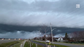
Active weather is the result of a delicate balancing act between extremes. The powerful upper-level ridge that brought Western Canada its hot and dry conditions allowed for one round of stormy weather after the next to traverse Eastern Canada. Many of the thunderstorms turned severe in the warm and soupy airmass parked over the region, and some of those storms produced tornadoes.
Ontario witnessed 10 of the 12 tornadoes that touched down in the country this July, bringing the province’s total to 14 (and the national total to 36) for the year. This puts the province ahead of the number of tornadoes reported in Oklahoma so far in 2021, another testament to the power of the persistent ridges that have built over the western half of North America.
Nearly half of Ontario’s tornadoes this year touched down in the July 15th outbreak across cottage country. The Northern Tornadoes Project confirmed six EF-2 tornadoes that day, becoming the region’s most significant tornado outbreak since the infamous event on May 31, 1985.
Three of the tornadoes on July 15th touched down around Lake Simcoe. Farther north, one twister struck east of Huntsville, and two more touched down in Algonquin Provincial Park. The most significant tornado on July 15th carved a 12 km path through neighbourhoods just southeast of Barrie.
A survey of the damage near Barrie revealed EF-2 damage, with maximum sustained winds reaching 210 km/h at the tornado’s strongest point. More than 100 homes were damaged and 11 people were injured.
DEVASTATING FLOODS HIT COMMUNITIES AROUND THE WORLD
The droughts affecting Canada and Siberia stand in stark contrast to the intense flooding that impacted communities around the globe. July witnessed several heavy rainstorms bubble up over areas ill-equipped to handle a sudden deluge.
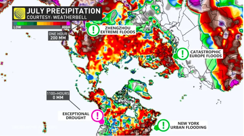
July’s worst flooding affected western Europe around the middle of the month. Intense floods killed more than 150 people as the waters swept through communities in Germany, Belgium, and neighbouring nations. A stalled low-pressure system led to several months’ worth of rain falling in a short period of time.
Floodwaters rushing down the Ahr River almost entirely destroyed the town of Altenahr, Germany. The community is nestled in a valley at the bend of a river, leaving it exceptionally vulnerable to a flash flood of this magnitude.
German Chancellor Angela Merkel toured hard-hit towns and said that the damage was “terrifying,” adding that “the German language can barely describe the devastation that's taken place,” as reported by Reuters.
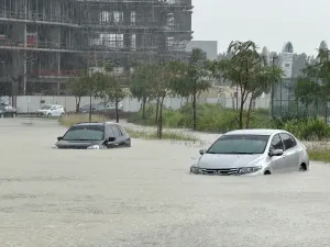
Flooding was also a serious issue in urban areas where rain fell faster than storm sewers could handle the runoff. New York City and Zhengzhou, China, are a world apart from one another, but they were both affected by drenching afternoon thunderstorms that produced notable flash flooding in each city.
Heavy rain associated with Tropical Storm Elsa flooded parts of New York City’s renowned subway system on the afternoon of July 8. The storm dropped more than 50 mm of rain in a short period of time, flooding stations and tunnels as commuters waded through chest-deep water to reach the exits.
A more harrowing situation played out a few weeks later in Zhengzhou, China, a city of more than 10 million people that sits about 600 km southwest of Beijing. A deep reserve of tropical moisture, combined with winds flowing up the side of nearby mountains, produced a rainstorm that dropped more than 600 mm of rain in one day, much of which fell in just a few hours.
The onslaught of water quickly overwhelmed natural and human-made drainage systems. The floods inundated parts of Zhengzhou’s subway system with chest-deep water, and heartbreaking footage emerged of countless water rescues within the city and its surrounding communities. More than 20 people died in the floods.
Thumbnail image courtesy 2 Rivers Remix Society/Facebook