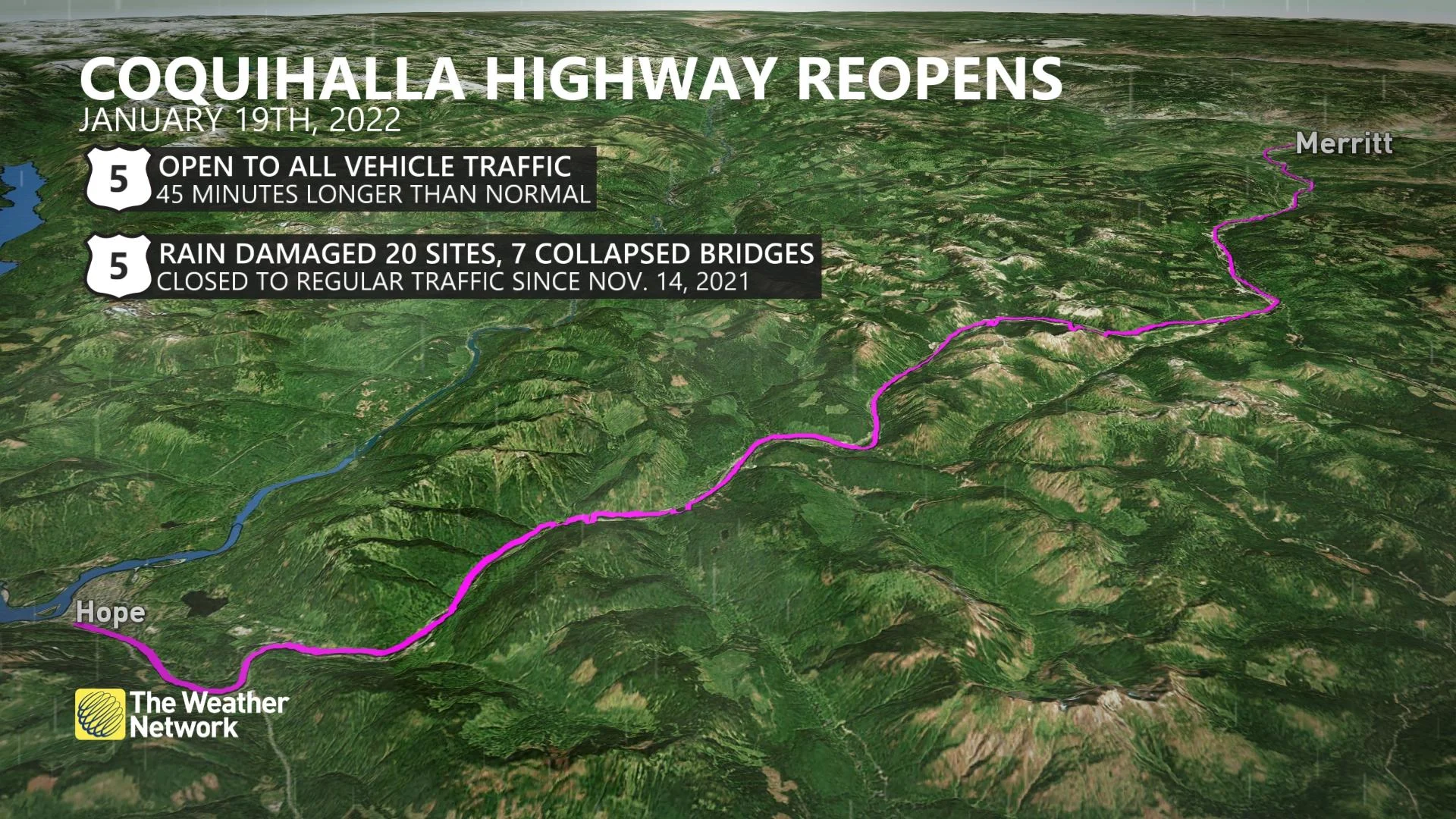
Coquihalla Highway reopening to regular traffic between Hope and Merritt
A section of the Coquihalla Highway will reopen on Wednesday following reconstruction after extensive flood damage, according to the B.C. government.
Transportation Minister Rob Fleming made the announcement about the section of Highway 5 between Hope and Merritt on Tuesday morning.
The ministry says temporary repairs to the route are now in place while it plans permanent fixes for damaged sections.
This means travel-pattern changes and reduced speed limits will be in effect, with Fleming saying the trip between Hope and Merritt would take about 45 minutes longer than normal.
There will be increased police enforcement to make sure people drive to conditions, and no electric vehicle charging stations will be available along this section of the highway for the time being.
"This is not the Coquihalla as we know it," said Fleming.
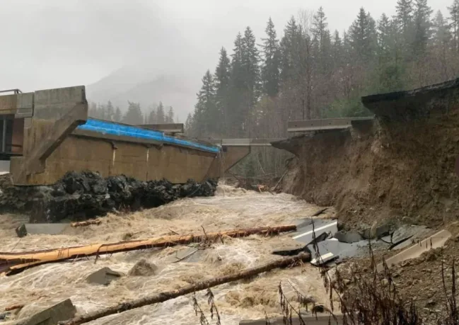
The province's highway network took a beating in mid-November when historic flooding caused complete road washouts and temporarily cut off the Lower Mainland from the rest of the country.
The Coquihalla Highway between Hope and Merritt has been closed to regular traffic since Nov. 14.
The arterial route that connects Metro Vancouver and the Fraser Valley to the B.C. Interior was damaged in more than 20 places after mudslides knocked out multiple bridges.
On Dec. 20, the Coquihalla reopened to inter-city buses and select commercial traffic only. As of that date, only commercial vehicles with a minimum licensed gross vehicle weight (GVW) of 11,794 kilograms were permitted on that highway.
Also Wednesday, the ministry announced that weight restrictions are being lifted for vehicles travelling on Highway 99 between Lillooet and Pemberton.
However, drivers of large commercial vehicles are discouraged from using this route, which should be used only by experienced winter drivers, as there is an increased avalanche risk through this corridor, the ministry said.
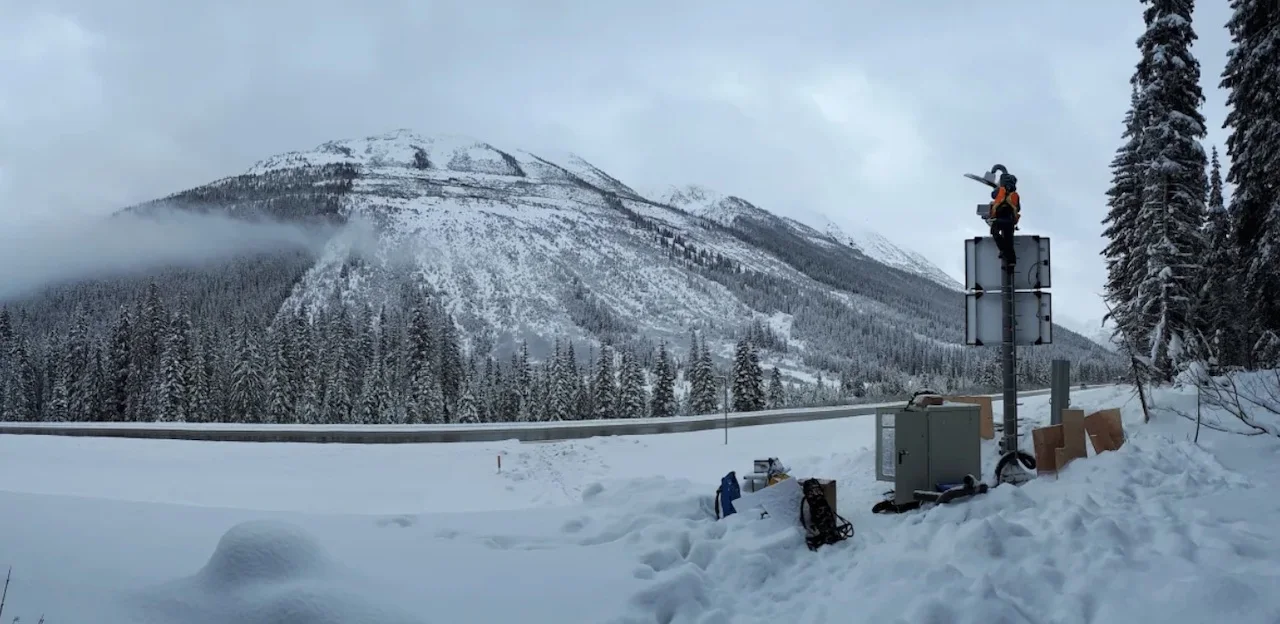
A worker installs a radar sensor in Glacier National Park to detect avalanches near the Trans-Canada Highway through Rogers Pass. (Parks Canada)
HWY 1 HAPPENINGS
Stretches of the Trans Canada Highway were also hit hard during the floods.
Highway 1 between Kanaka Bar and Hope remains closed after record snowfalls and recent avalanche risks delayed reconstruction work around Jackass Mountain.
However, the province says crews are back on site and the highway is expected to reopen to all vehicle traffic before the end of January.
When Highway 1 does reopen through the Fraser Canyon, Fleming says delays of up to two hours should be expected.
Those delays, says the province, are a result of ongoing repairs, an at-grade train crossing, avalanche control and sections of single-lane alternating traffic, which includes a temporary single-lane bridge at the Jackass Mountain and Nicomen River crossing.
The transportation ministry says loads on this section of Highway 1 will be limited to 25 metres in length until the rehabilitation of the highway bridge at Nicomen River is completed.
Last Thursday, the Trans Canada partially reopened between Kanaka Bar, south of Lytton, to Spences Bridge. Drivers can also expect delays on this section.
For the latest road closures and conditions province-wide, visit DriveBC.
WATCH: CANADIAN WEATHER EVENTS THAT MADE HEADLINES IN 2021
The story, written by Bridgette Watson, was originally published for CBC News on Jan. 18, 2022.


