
Storm risk pushes eastward on the Prairies as helpful rains persist

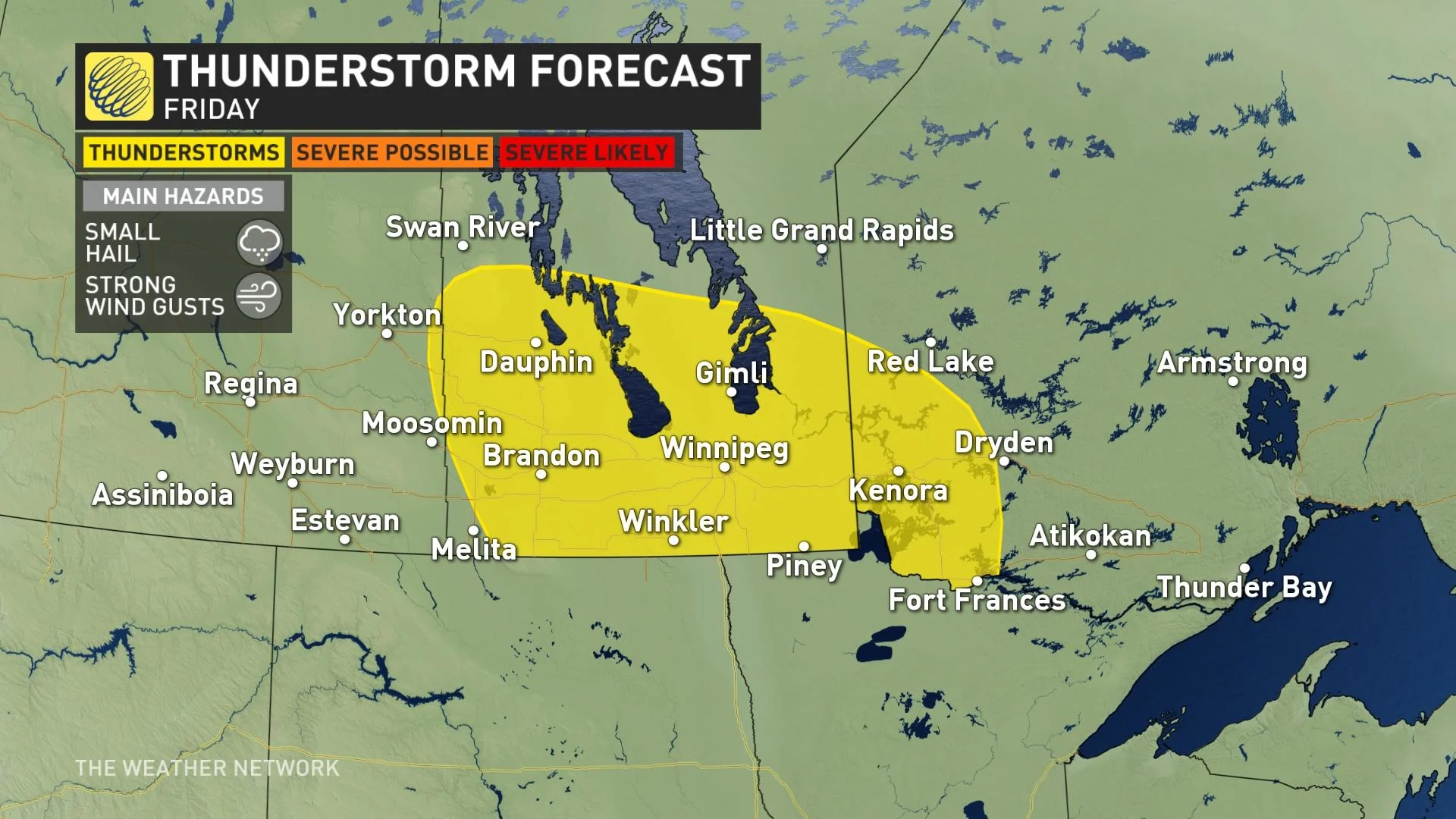
After intense thunderstorms roared through southern Saskatchewan Thursday, the threat will be diminish somewhat Friday, shifting east across the Prairies. Meanwhile, parts of the drought-stricken region will continue to get doused with much-needed rainfall.
Storms fired up stateside Thursday and swept through Saskatchewan with threatening clouds, heavy downpours and hail, even some localized flooding in some parts of the province. The storms in Saskatchewan will gradually wind down in the overnight period, while Manitoba may see severe thunderstorms during this time. By Friday, the thunderstorm risk subsides -- remaining non-severe in nature and shifting east across southern Manitoba, and into northwestern Ontario. In addition to the thunderstorm threat, the days-long rainfall that will be a big help to farmers in the drought-plagued region will continue Friday, with amounts of 75-100 mm in line for parts of Saskatchewan by Saturday. Beyond the weekend, the sizzling heat will return next week, along with severe storm potential for Alberta. A look ahead, below.
Visit our Complete Guide to Summer 2021 for an in-depth look at the Summer Forecast, tips to plan for it and much more!
FRIDAY: SLUGGISH SYSTEM SOAKS DROUGHT-HIT AREAS, STORM RISK MOVES EAST
The sluggish system responsible for Thursday's severe weather and heavy rainfall on the Prairies will continue to produce downpours across parts of all three provinces Friday, with the heaviest focused in eastern Saskatchewan. Some areas may struggle with localized flooding.
This is most welcomed news for farmers, however, since the rain will certainly make a dent in the long-standing drought conditions that have plagued the region for months.
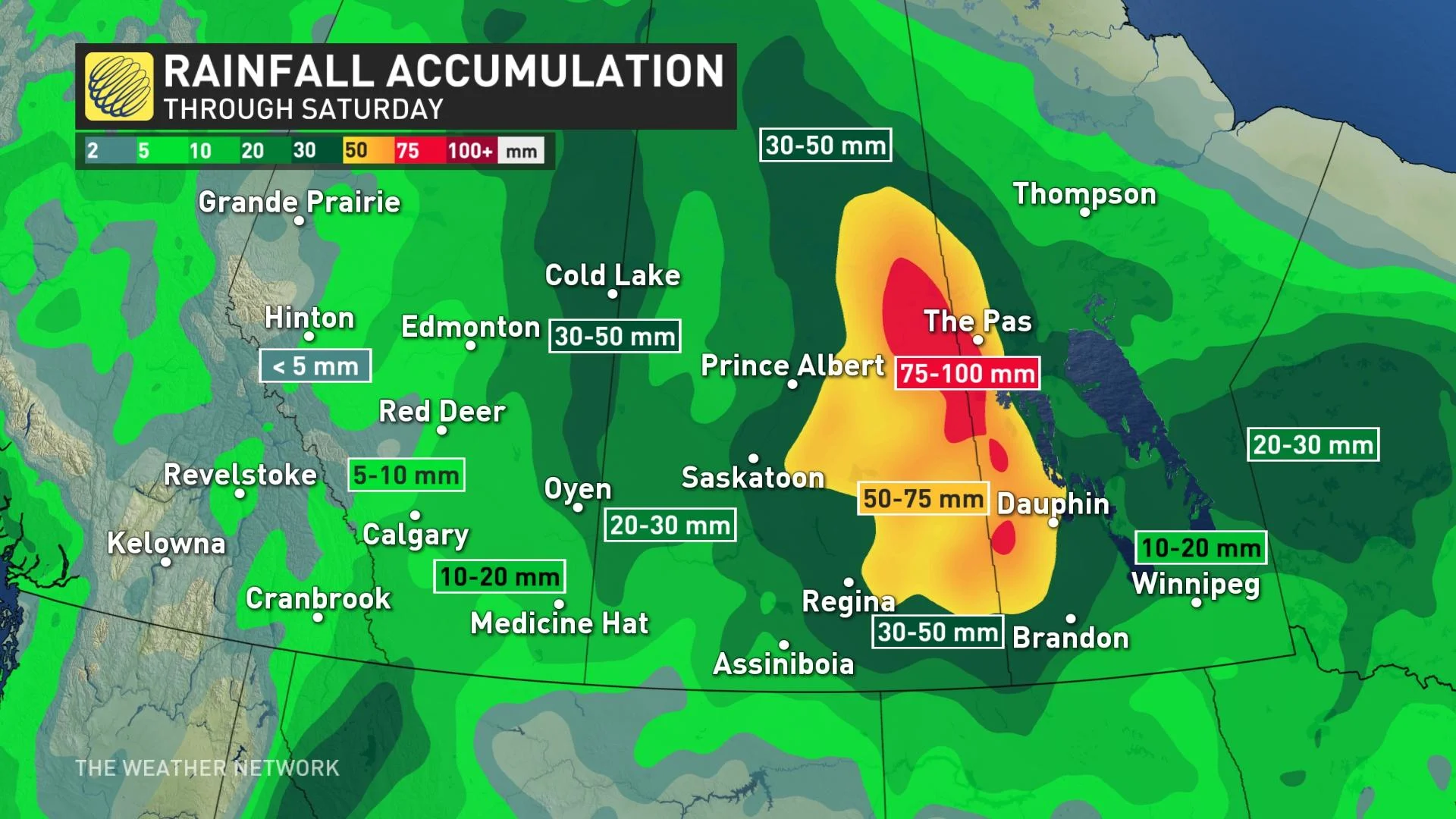
Not everyone will get the worst of it, but almost everyone will get at least a shower. Parts of eastern Saskatchewan could end up receiving 75-100 mm of rain by Saturday.
Meanwhile, the thunderstorm chance will diminish somewhat Friday, and will linger in southern Manitoba and extend into northwestern Ontario for the afternoon and evening hours.
Any storms that do develop should remain non-severe in nature, and may bring heavy rainfall and small hail.
LOOK AHEAD: HEAT, SEVERE WEATHER RISK RETURNS NEXT WEEK
Temperatures will recover back to seasonal for the start of the weekend for western areas of the Prairies, continuing to warm up through the weekend and early next week.
Beyond the weekend, very hot weather will spread across the region early and mid-week.
Temperatures will hit the low- to mid-30s for southern areas, but the heat will only stick around for a couple days with cooler weather spreading back into the region for the end of the week, and Father’s Day weekend.
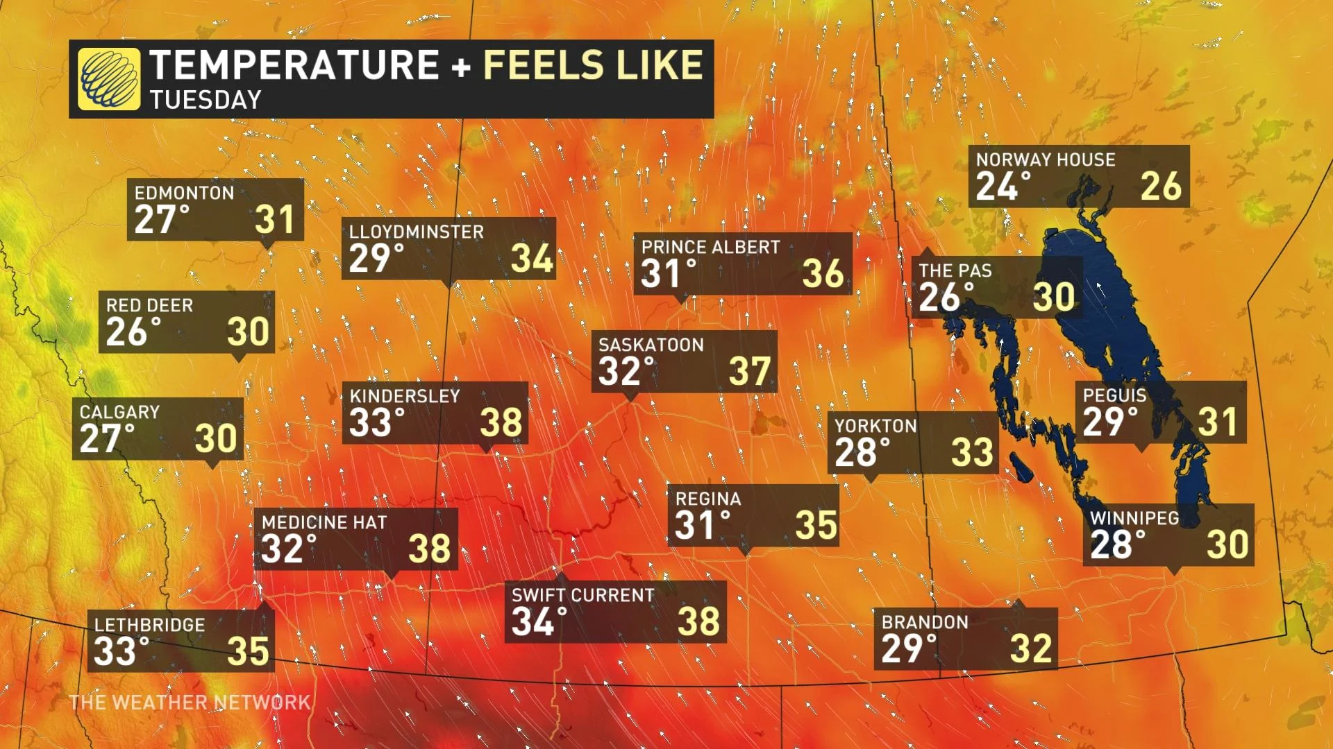
A dry pattern is expected to return to southern areas of the Prairies for next week, and beyond). However, a significant severe weather event is possible for central and northern Alberta Tuesday, possibly lingering into Wednesday.
A strong system is expected to develop over Alberta, and then track east across the northern Prairies with widespread heavy rain and strong winds, but most of the rain is expected to be across northern parts of the region -- north of the primary agricultural areas.
Forecasters are watching the potential for hot weather to return to southern sections of the Prairies for the final week of June.
Stay tuned to The Weather Network for the latest forecast updates across the Prairies.