
Snow, plunging temperatures set to mark the weekend in Alberta

A morning shot of snow Friday gave way to a heavier dose in the afternoon and evening, even in places as far from the mountains and foothills as Calgary. That snow will continue into Saturday morning for some areas, while beyond, another round awaits, amid markedly cooler temperatures lasting well into next week. A closer look, below.
WEATHER HIGHLIGHTS:
Snow ends by Saturday morning, but second, lighter round moves in late Saturday
Daytime highs remain below freezing for most of Alberta throughout the weekend
More active weather possible next week
SATURDAY EVENING INTO SUNDAY: ROUND TWO SNOW POTENTIAL
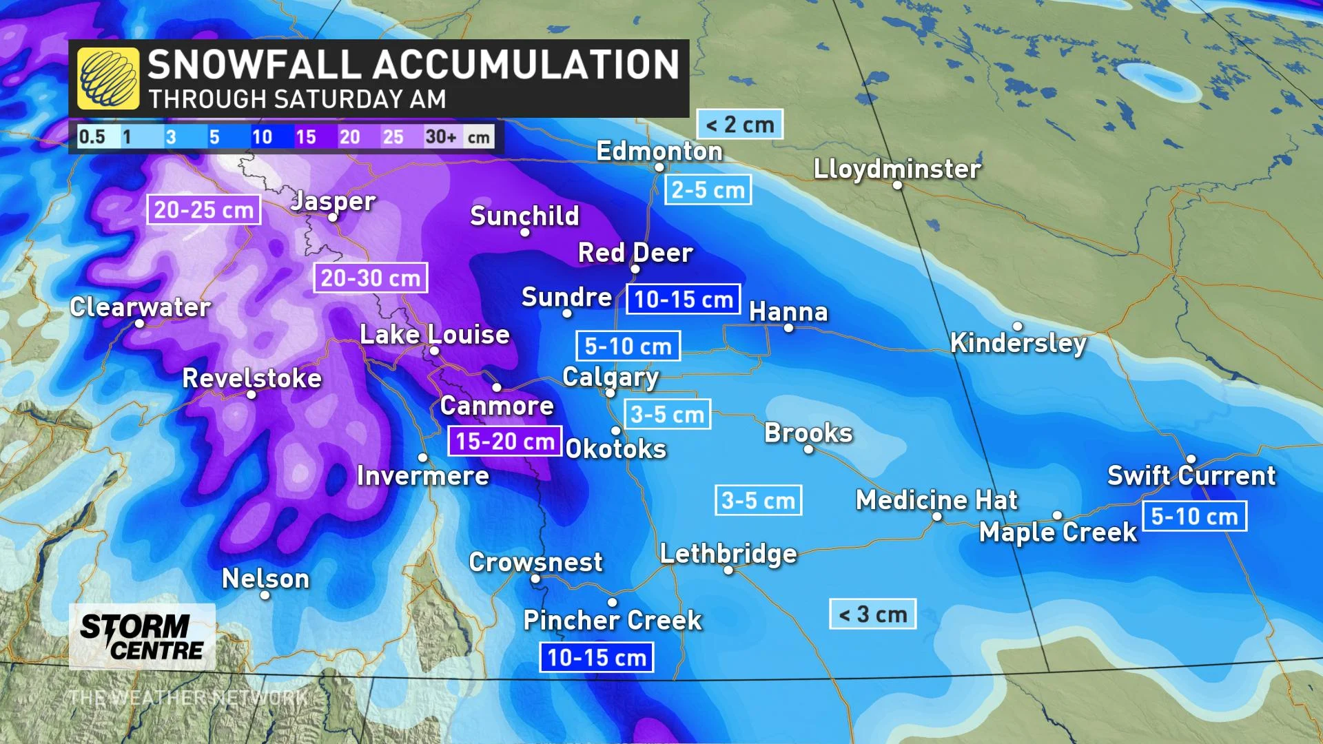
Snow made for some difficult travel for parts of southern Alberta Friday, starting with a morning round lingering on from the previous evening, then a second, more intense round later in the day, set to last through the evening. All worsened by winds strong enough to trigger wind warnings later Friday.
By Saturday morning, most of the snow will be done or tapering off, with parts of the mountains getting 15-30 cm over the course of the event, with parts of south-central Alberta around Red Deer and Sundre getting 10-15 cm. Even parts of Calgary may have gotten 5-10 cm, while Edmonton will escape with just a dusting, if that.
There will be a breather for much of the day, but another moisture-laden Pacific low will soon be coming in through southern British Columbia. There's low confidence as to how much snow falls with this secondary low, though it's likely to be much less significant than initially expected.
The snow looks to spread along the foothills and toward the QE2 Saturday night into Sunday.
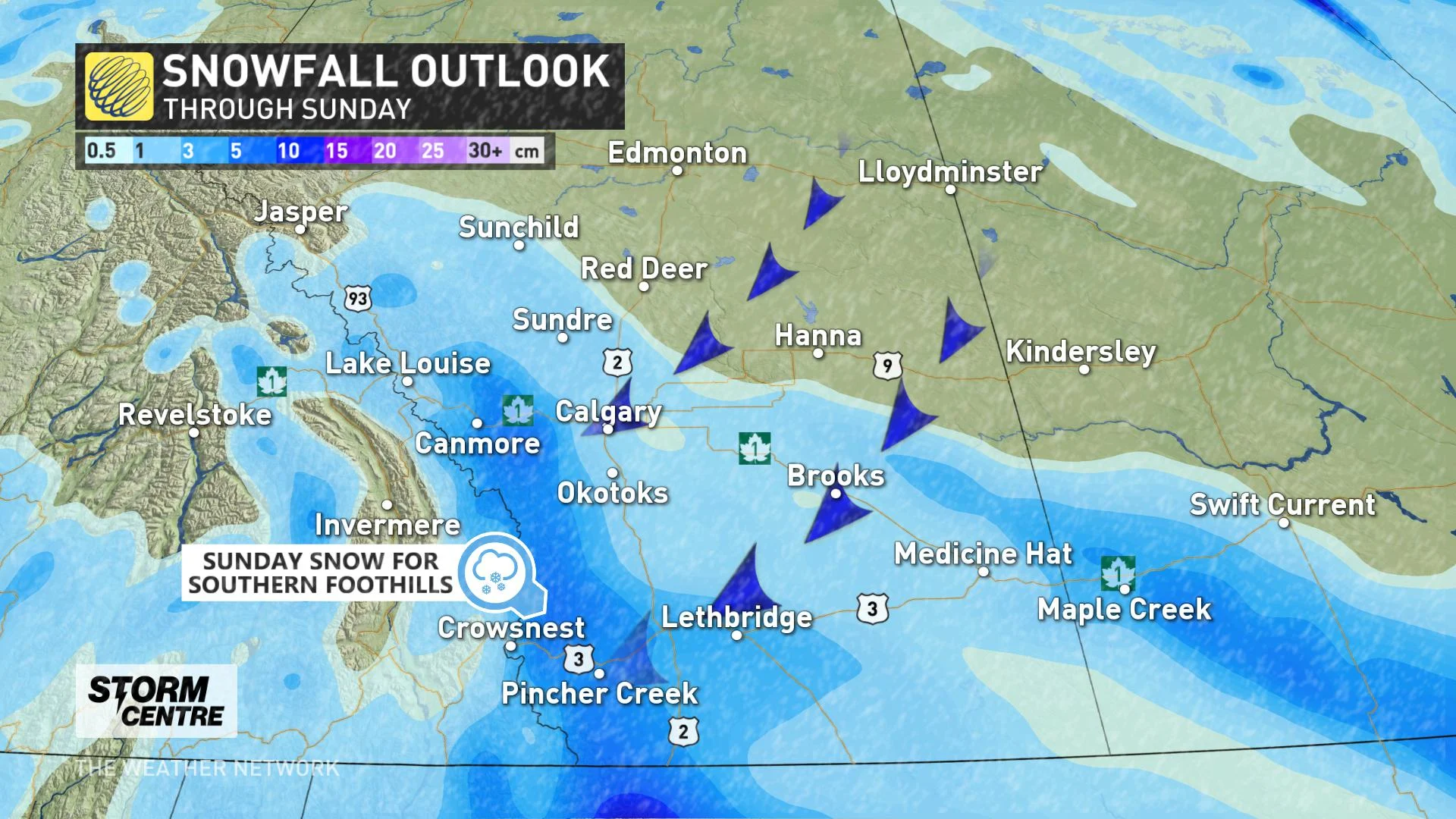
Parts of southwestern Saskatchewan can also expect to see the flakes fly through the weekend.
Temperature-wise, Alberta's daytime highs look to remain below freezing throughout the weekend, with parts of the western Prairies sitting about 15 degrees below seasonal.
WATCH BELOW: ALBERTA, BRACE YOURSELF FOR A RECORD-BREAKING OCTOBER COLD-SNAP
BEYOND: COLD TEMPERATURES LINGER INTO NEXT WEEK
In fact, if the forecast high for Edmonton stays below -2°C on Saturday, it'll be one of the top 10 coldest early fall days on record. We are currently forecasting one of the longest stretches in Edmonton history to be below zero for the month of October, with 11 straight days of frosty weather coming up. It's a similar situation with the city of Calgary, except the temperature there is set to rise above freezing on Tuesday, leaving a forecast streak of four days below freezing.
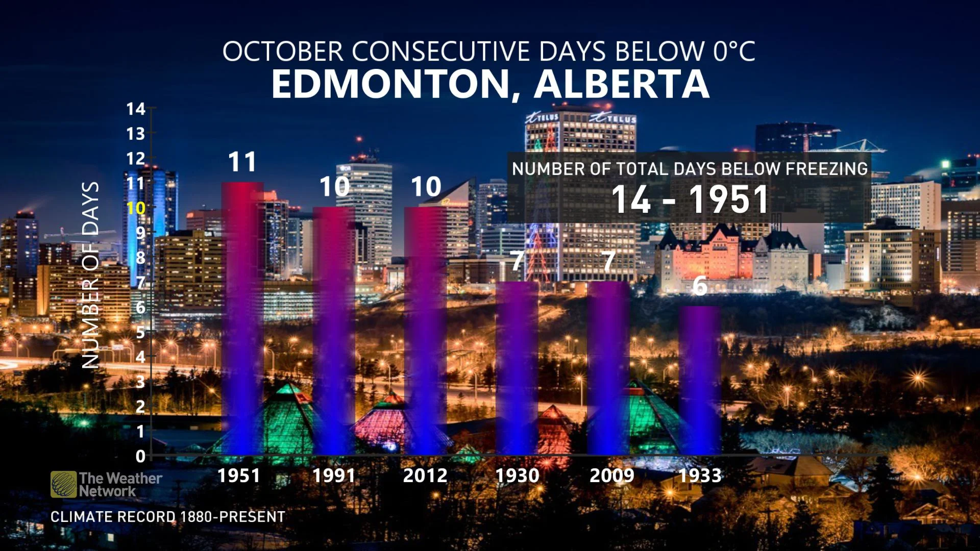
"This is unusually early in the season to have such an extended stretch of sub-freezing temperatures," says Weather Network meteorologist Dr. Doug Gillham.
In terms of precipitation, another weak system looks to track across the region early next week with a few centimetres of snow to central and southern Alberta. We are also watching the potential for a more significant system Wednesday for southern and western Alberta.
Be sure to check back as we continue to provide updates on this extended period of winter weather.
Thumbnail Image Credit: Pat Boomer/Twitter