Avalanche, flooding risk high in B.C., end in sight to atmospheric rivers

There is light at the end of the atmospheric tunnel for B.C. as the province endures one more day of rampant rainfall Wednesday before getting a much-deserved break for the end of the week. The third and final atmospheric river will hold on tight for a chunk of Wednesday, tapering off to scattered showers in the afternoon and evening. With plenty of rainfall still to come, further flooding, mudslides and avalanches are likely to worsen an already destructive situation. B.C has already seen its first avalance death of the season, occurring last weekend. More on the impacts, timing and when the unrelenting rain will come to an end, below.
Visit our Complete Guide to Winter 2022 for an in-depth look at the Winter Forecast, tips to plan for it, and much more!
WEDNESDAY: ATMOSPHERIC RIVER FLOWING WITH HEAVY RAIN, RISK FOR MORE AVALANCHES
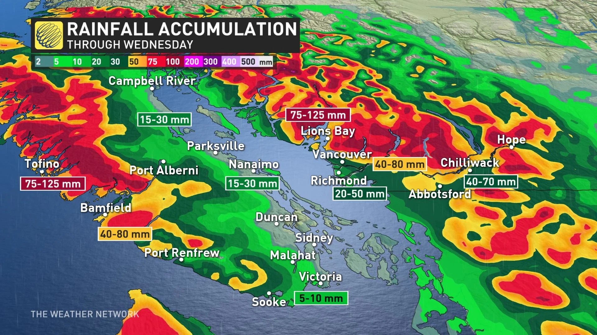
Moisture associated with this atmospheric river originated 8,000 km away in the Philippines. The vapour’s long trek across the Pacific has yielded significant rainfall at lower elevations and snow at higher elevations across the southern half of B.C., leading to a risk for further flooding, mudslides, and avalanches across the region.
The last of a trifecta of atmospheric rivers in recent days isn't turning out to be as impactful for the Lower Mainland. Its west-to-east orientation will allow Vancouver Island to wring out much of the moisture before it reaches the Lower Mainland.
Heavy rain will ease somewhat overnight Tuesday, but will reintensify on Wednesday morning as a cold front moves across the South Coast. The rainfall will then relent in the afternoon, tapering to scattered showers that will linger through the evening.
The highest totals are likely on western Vancouver Island and at higher elevations, where 75-125 mm of additional rainfall is still to come through Wednesday. Further amounts of 20-50 mm are possible around Metro Vancouver.
A barrage of special weather statements, rainfall, snowfall, wind and winter storm warnings remain in place across the province.
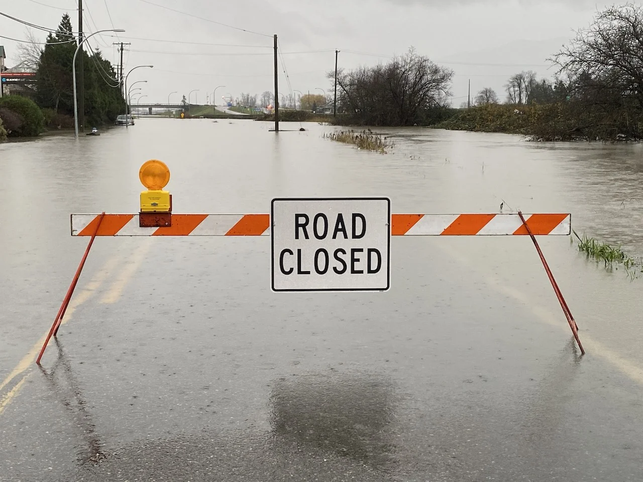
“Heavy downpours are likely to cause flash floods and water pooling on roads. Localized flooding in low-lying areas is possible. Don't approach washouts near rivers, creeks and culverts,” Environment and Climate Change Canada (ECCC) said in the rainfall warning.
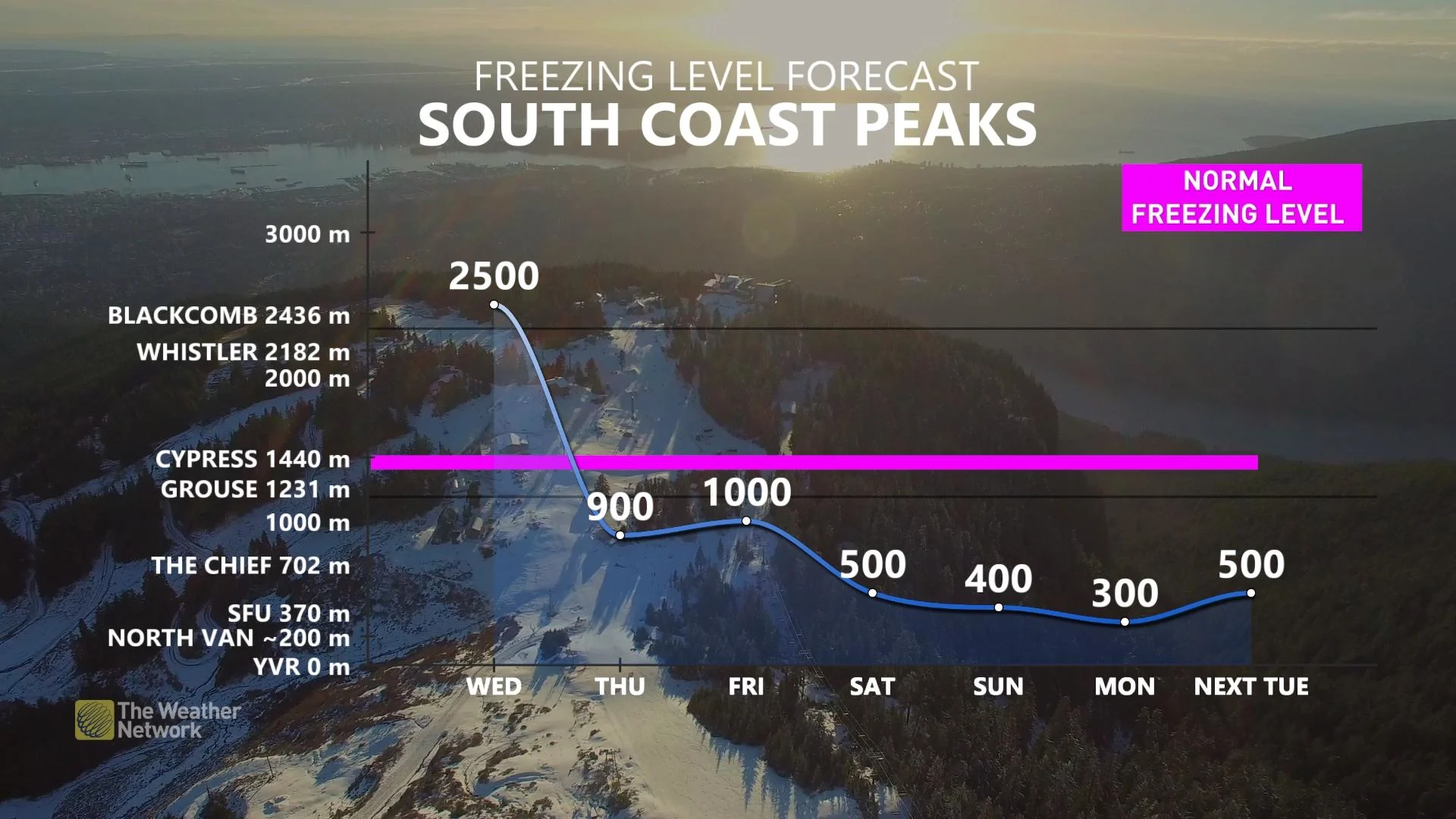
Runoff from snowmelt and a risk for avalanches will become a concern through Wednesday as freezing levels quickly rise. Continued snowmelt will further swell B.C.’s rivers, increasing the threat for flooding at lower elevations.
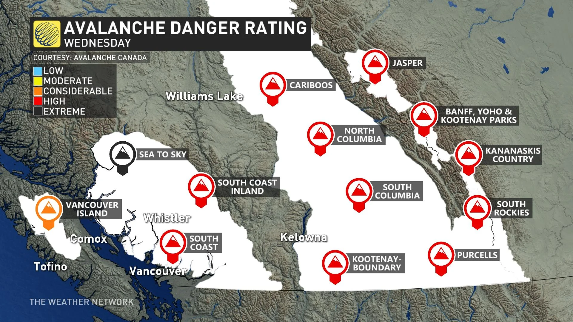
The avalanche danger rating will remain high at all elevations for ranges on the South Coast, and Interior sections on Wednesday, while it drops to a considerable level on Vancouver Island. An extreme avalanche danger exists at the alpine level across Sea to Sky, according to Avalanche Canada.
B.C. just recorded its first avalanche death of the season last weekend, CBC News reported. The fatality occurred on Saturday afternoon when four snowmobilers were riding in the Hasler area of the North Rockies, near Chetwynd.
HEAVY RAINFALL KEEPS B.C. COMMUNITIES ON ALERT FOR POSSIBLE FURTHER FLOODING
THURSDAY AND BEYOND: A BRIEF BREAK BEFORE THE NEXT UNSETTLED WEATHER
Calmer conditions will arrive in B.C. to end the week as a ridge of high pressure builds over the region. Sunshine and seasonal temperatures will prevail across Metro Vancouver on Thursday and Friday.
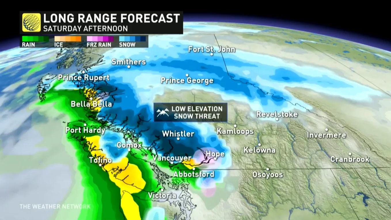
The break will prove short-lived, though, as another storm will reach B.C. this weekend. This system looks much weaker than what the region has had to contend with for the past couple of weeks. However, falling freezing levels could bring a threat for low-elevation flurries on Saturday including in Metro Vancouver.
Beyond, the active pattern continues through early December. With colder weather spreading into the region, freezing levels with systems this weekend and next week will be much lower -- which is good news for ski areas. In the long range, while confidence is very low at the moment, but there is the potential for low-elevation snow, including in the southern Interior.
Check back for the latest on the heavy rain and avalanche danger across British Columbia.


