Impossible travel across parts of Newfoundland as winter storm hangs on

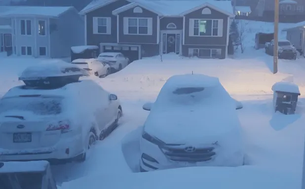
March certainly roared in like a lion across the East Coast on Monday, with a powerful winter storm that delivered strong winds, heavy snow, and rain across the Maritimes. The storm left behind frigid temperatures and wind chills throughout the Maritimes Tuesday, as well as intense wind gusts, while northern parts of Newfoundland and Labrador are still dealing with heavy snow and howling winds through Tuesday night. This will make for dangerous blizzard-like conditions and treacherous travel. Peak wind gusts have come down, but parts of the Maritimes could see them in the 90 km/h range, with 60-80 km/h gusts for Newfoundland. More on the impact and timing, below.
WEATHER HIGHLIGHTS:
Snow lingers in northern Newfoundland, Labrador, Gulf of St. Lawrence Tuesday
Possible blizzard conditions, intense wind gusts, 40-50+ cm anticipated for parts of Labrador through Wednesday
Temperatures take a nosedive in Maritimes, winds remain strong
More wintry weather mid-week
TUESDAY: TREACHEROUS CONDITIONS LINGERS IN NORTHERN NEWFOUNDLAND, FRIGID CHILL FOR THE MARITIMES
The intense winter storm that powered through the Maritimes and Newfoundland to kick-start the first week of March is on winding down Tuesday after bringing a healthy dose of snow, powerful winds and rain.
"It's the winter storm that does not want to quit," says Weather Network meteorologist Jessie Uppal. "It continues to show signs of strengthening as it spins and sits over the Gulf of St. Lawrence."
What's left of the storm will see lingering impacts through Tuesday evening along the northern coast of Newfoundland, as well as along the Gulf St. Lawrence.
Visit our Complete Guide to Spring 2021 for tips to plan for everything ahead!
Winter storm warnings have been dropping across the island, with remaining alerts in northern sections and Labrador. Although conditions will ease in the overnight hours, they will deteriorate again on Wednesday night and persist into Thursday.
Gusty easterly winds combined with the fresh snow will cause reduced visibilities in blowing snow. The highest snowfall amounts are expected inland and over higher terrain. Through Wednesday, some areas in Labrador are in line to see accumulative totals of 40-50+ cm.
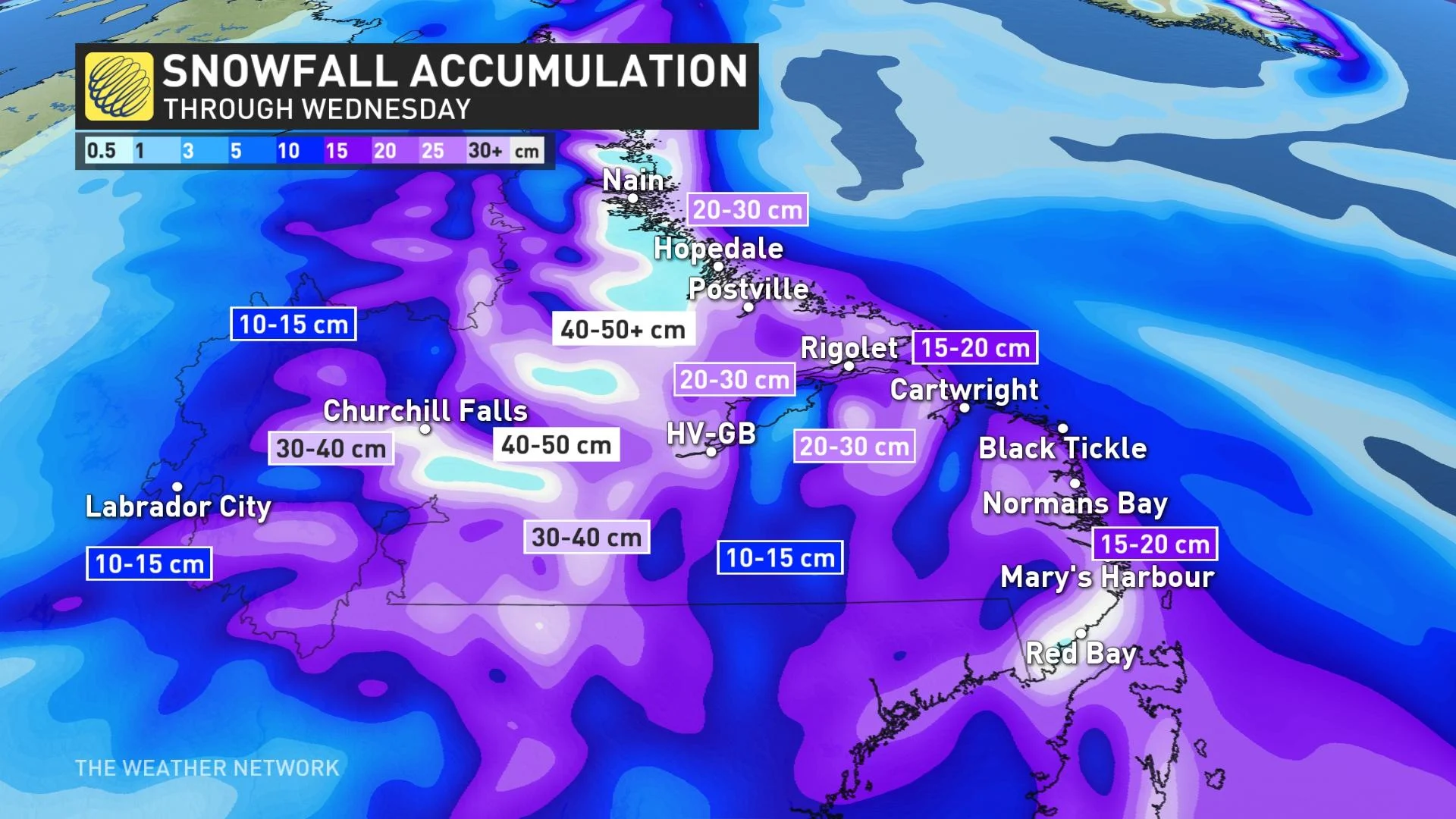
Easterly wind gusts will be strong, ranging from 60-80 km/h, which could make for hazardous travel as visibilities will be reduced from blowing snow.
"Prepare for quickly changing and deteriorating travel conditions," Environment Canada warns. "Visibility will be suddenly reduced to near zero at times in heavy snow and blowing snow."
Most government offices and municipal services were either delayed with opening or closed for the day early Tuesday, as the conditions quickly began to deteriorate through the overnight and pre-dawn hours.
Sections of the Trans-Canada Highway were also closed on the west coast, with drivers being urged to postpone travel until conditions improve. Several flights and ferry crossings have been cancelled as well.
Meanwhile, the Maritimes contended with a drastic temperature drop Tuesday -- from the low single digits in some areas to the minus double digits for most. The wind chills will be bitter, making it feel close to, at or above -20 across the Maritimes.
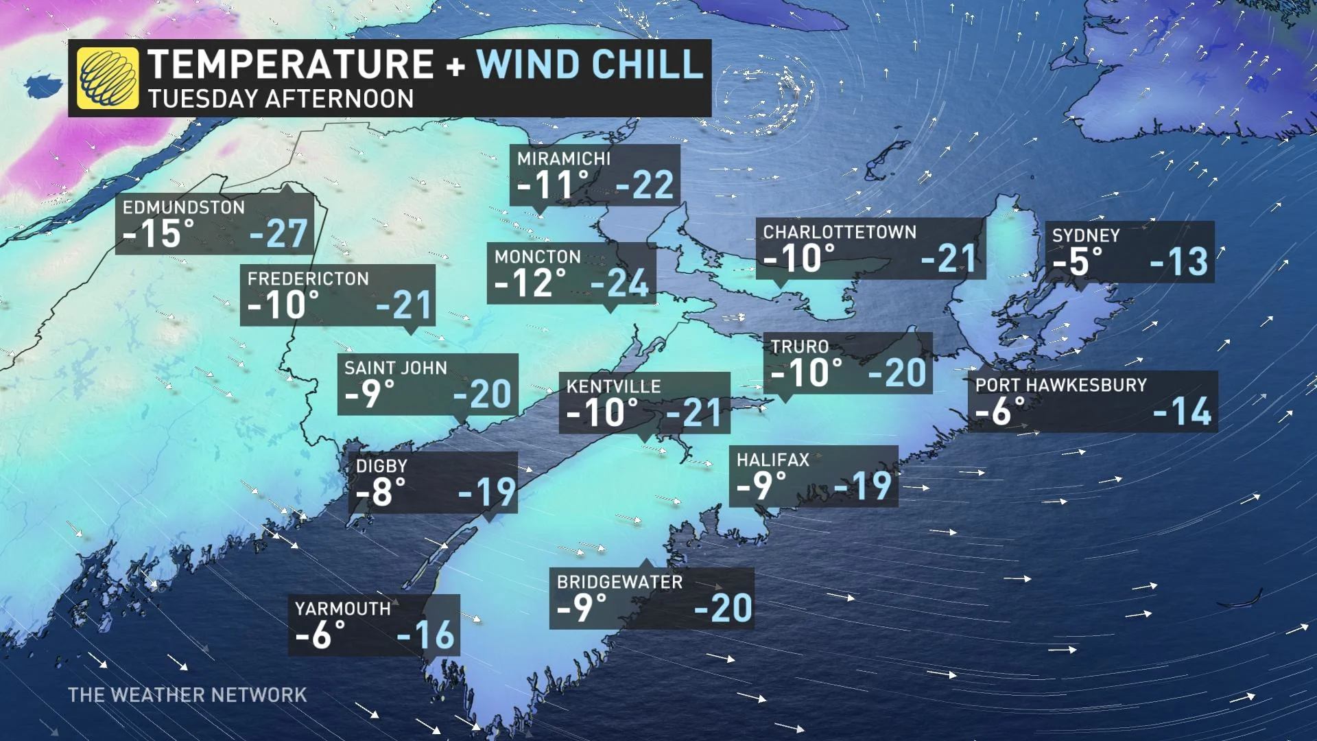
The Maritimes are also dealing with intense winds, with wind warnings in place in northern New Brunswick and Nova Scotia. Howling west-northwest wind gusts up to 90 km/h will persist until the evening hours for parts of both provinces.
Eastern Nova Scotia will continue to be brushed by sea-effect snow into Wednesday, with gusty winds continuing Wednesday in Newfoundland and lingering snow showers across the island, as well.
TEMPERATURE SWING COULD LEAD TO ICY MESS IN ATLANTIC CANADA
Forecasters are also keeping a close eye on a potentially strong storm over the Atlantic later this week, which could have a major impact on the region if it tracks in close enough.
Be sure to check back for the latest updates on the active weather pattern persisting across Atlantic Canada.
Thumbnail image courtesy: Corina Norris Reid


