Hordes of dragonflies throng weather radar screens

Weather radar is a critical tool for forecasters to monitor severe weather as it unfolds, but it's apparently sensitive enough to pick up some decidedly un-weathery elements -- at least, if enough of them take wing.
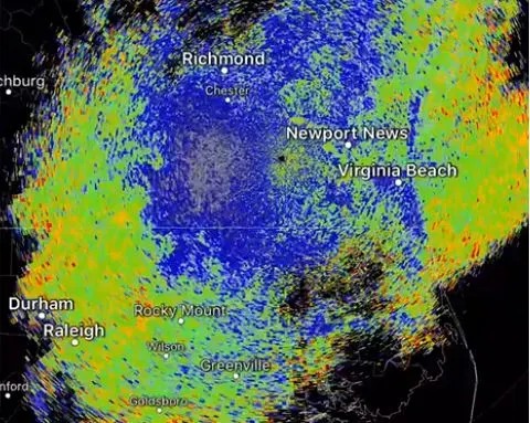
Several regional offices of the U.S. National Weather Service on or along the U.S. Mid-Atlantic coasts reported seeing some major activity on their screens at times where there shouldn't have been any rain or other weather.
Upon closer examination -- and with some help from people sending in on-the-ground photos, the answer was discovered: The blips were countless thousands of migrating dragonflies.
"They look like a cumulus field, when you pick them up on radar,” Tom Mazza, a meteorologist at the NWS’s Charleston Forecast Office, told West Virginia's Charleston Gazette-Mail earlier in the week. “I’m wondering if they fly in updrafts under cumulus clouds, and travel at the base of the clouds.”
It may have come as a surprise, but only a short-lived one: CNN reports similar phenomena were observed in the U.S. midwest a few days prior.
Other insects, such as ladybugs and monarch butterflies, can be spotted on radar if they swarm in large enough numbers, along with flocks of birds, but Mazza told the Gazette-Mail it's unusual for dragonflies to make a similar appearance.
The weather can and does play a role in insect swarms. Earlier this year, normally dry Nevada experienced a wetter-than-normal first half of the year, leading to near-biblical levels of grasshopper swarms that made international headlines.