Is that a tornado? Ontario proves to be ‘oddball’ of storm development

Reporter and storm chaser Mark Robinson reveals why chasing storms in Ontario can be equally exciting as they are frustrating.
Welcome to storms in Ontario. Where the rules are made up and physics doesn’t matter. A place where what should happen, doesn’t, and what shouldn't, does.
Of course I’m being facetious here, but that was my thinking as I stared at the rapidly spinning coil of cloud just over the trees on the other side of the field on July 29.
Sometimes it’s hard to tell if you’ve got a real funnel in Ontario, but this was absolutely, no question, the beginning stages of a supercell tornado right near the town of Tilbury.
And I was in its path.
Chasing thunderstorms in Ontario is not easy given the forests, the messy storms and the urban areas, but we happen to sit on the convergence area of a number of different storm systems. We can get low pressure systems that roll out of Texas, Colorado, Alberta, and even ones that come up the East Coast. It means that I often get quite busy in the summer trying to track down the most dangerous thunderstorms to get them on air back at The Weather Network.
Wednesday started off with my head buried in a computer, trying to figure out the best spot to be in. The forecast models were showing an area of storms likely to fire up around the Lake St Clair region and then track through Chatham. Surprisingly, there was a small area of good wind shear (winds moving in two different directions as you go up through the atmosphere) around the lake and along the shores of Lake Erie.
That got my attention, so I piled my gear into the car and headed down to the southwest. The early morning felt cooler and drier than it had felt for a while, but I expected that to change into the afternoon.
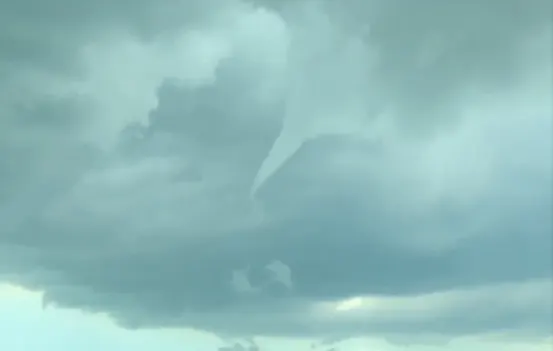
As I headed down the 401 towards Chatham, the highway led me through the town of Tilbury. A storm had sprung up just on the western side so I pulled off the road to get a good look at it. As I did so, what looked to be a funnel poked down out of an area of cloud that was still visible as it got squeezed between rain cores.
Thunderstorms are all about organization. Without that, they fade out quickly as the inflow region (the area where warm, humid air -- or fuel -- flows into the storm) can get cut off by the cold, drier air descending back out of the storm. The storms that I was looking at had more organization than I thought they would.
I followed the storm south to see if it would produce a funnel again, but once was all the storm could manage. I even let the core run over me to see what kind of winds were in there, but alas, all I got was a bit of rain and some leaf flutter. Welp, that’s that then. Storms are done and time to head home.
As I stood at the side of the road marveling at the golden glow of ripe wheat beneath the ominous dark blue grey of the dissipating supercell, my phone dinged with a message from Matt Grinter, our briefing meteorologist back at the office.
“Go north, new areas of rotation in the storms coming across Lake St Clair.”
Since Matt is a brilliant forecaster (and chaser) I heeded his words and headed north back up towards Tilbury and Lake St Clair. Maybe the day wasn’t over yet.
The storms were already moving off the lake and I knew that if I could make it to them as they encountered a boundary left by the earlier storm they might just look interesting. When meteorologists talk about boundaries, they’re talking about a pool of cold air left by a storm as it moves across the landscape. The edge of this cool air is known as an “outflow boundary” and they can often be the focus for new storm development or as an enhancement focus for ongoing storms.
The towering clouds of the Lake St Clair storms loomed above me and the sun was soon obscured by them as I raced to get underneath and see what the storms were doing at the surface. If they’d managed to tap into the surface air (the densest and richest layer of warm, humid air) they might be able to really get fierce.
Minutes later a shelf cloud, one of the wonders of the thunderstorm world, loomed into view.
These clouds form on the inflow/outflow area of a strong thunderstorm and while incredibly dramatic, aren’t particularly dangerous. Yes, they can produce strong winds and even small hail, but they don't have the rotation that characterizes supercell storms.
I stayed with the shelf, gleefully taking pictures and sending footage back to The Weather Network, but then I noticed that the storm to my west was beginning to show some rotation. This was clearly an invite by Mother Nature herself.
After some frantic (but safe) driving down roads that unexpectedly ended (update your maps Mark!), and some minor offroading (don’t ask), I pulled onto a paved road and raced west just in time to see that classic supercell structure, a rotating wall cloud.
These clouds form under a spinning storm and are created by the interaction of the warm, humid air flowing into the storm with the cold, rain filled core air descending out of the storm. Only the most organized and vigorous supercells produce wall clouds and they form the precursor to a funnel or tornado.
Which is exactly what was happening right in front of me.
Often, clouds we call scud (Strato Cumulus Under Deck) hang down below a storm in straggly fingers and cause lots of people to excitedly call into The Weather Network reporting funnels. A real funnel has very smooth sides and the rotation can clearly be seen.
I screeched to halt, leaped out of the car and started filming as the funnel spun up into a long finger that descended towards the ground. We don’t yet have a good handle on how tornadoes are formed, but this had all the hallmarks of a potential one.
I glanced upstream of the funnel and noticed that there were few, if any structures in its way. If this did touchdown, it wasn’t going to hit much.
For about three minutes, the funnel spun above me and then began to fall apart, the spin degenerating into wisps of cloud that sailed around the centre of motion, disappearing as the funnel was taken over by the mass of grey above it.
I’d managed to catch the last stage of a potential tornado on a day that should have been nothing but rain, wind and maybe some hail. Once again, Ontario had proven to be the oddball of thunderstorm development and luckily for me, I’d happened to be in the right place at the right time (along with a bunch of other chasers – I’m not the only one in Ontario!).
Ontario is one of the more difficult places to find that ever elusive supercell or tornado, but as we understand more and refine how to forecast an area that is surrounded by the vast weather generators of the Great Lakes, it may get easier to know where they’re going to show up.
But I doubt it. Here, the meteorological rules are made up and physics doesn’t matter. I’m convinced of it.
Follow Mark Robinson on Twitter (@StormhunterTWN) to catch his next adventure!