'African wave train' continues picking up steam for 2020 hurricane season peak

The Atlantic is buzzing with activity, with four tropical disturbances. Three are part of an African wave train -- a series of African waves that can develop into tropical systems.
After Laura and Nana made landfalls as categories 4 and 1 hurricanes, respectively, recently, what does the rest of the 2020 Atlantic season have in store?
Now that September is upon us, statistics tell us that we should be on guard now more than ever for tropical development: the month is deemed the peak of the hurricane season, and this year likely will be no exception.
FAVOURED TROPICAL TRACKS IN SEPTEMBER
Some notable storms that we can recall in September are very memorable for several reasons. 2017's Hurricane Irma, for example, was an extremely powerful Cabo Verde hurricane that caused widespread destruction in Florida.
Irma was the first Category 5 hurricane to strike the Leeward Islands on record, followed by Maria two weeks later. Another notable September hurricane was Hurricane Hugo in 1989, which made multiple landfalls over the course of five days in Guadeloupe, Saint Croix, Puerto Rico, and South Carolina. All of these storms have taken similar paths to these displayed below.

WHY DOES ACTIVITY PICK UP IN SEPTEMBER?
We typically see more frequent tropical systems, with greater lifespans and greater intensity, in September due to a few factors.
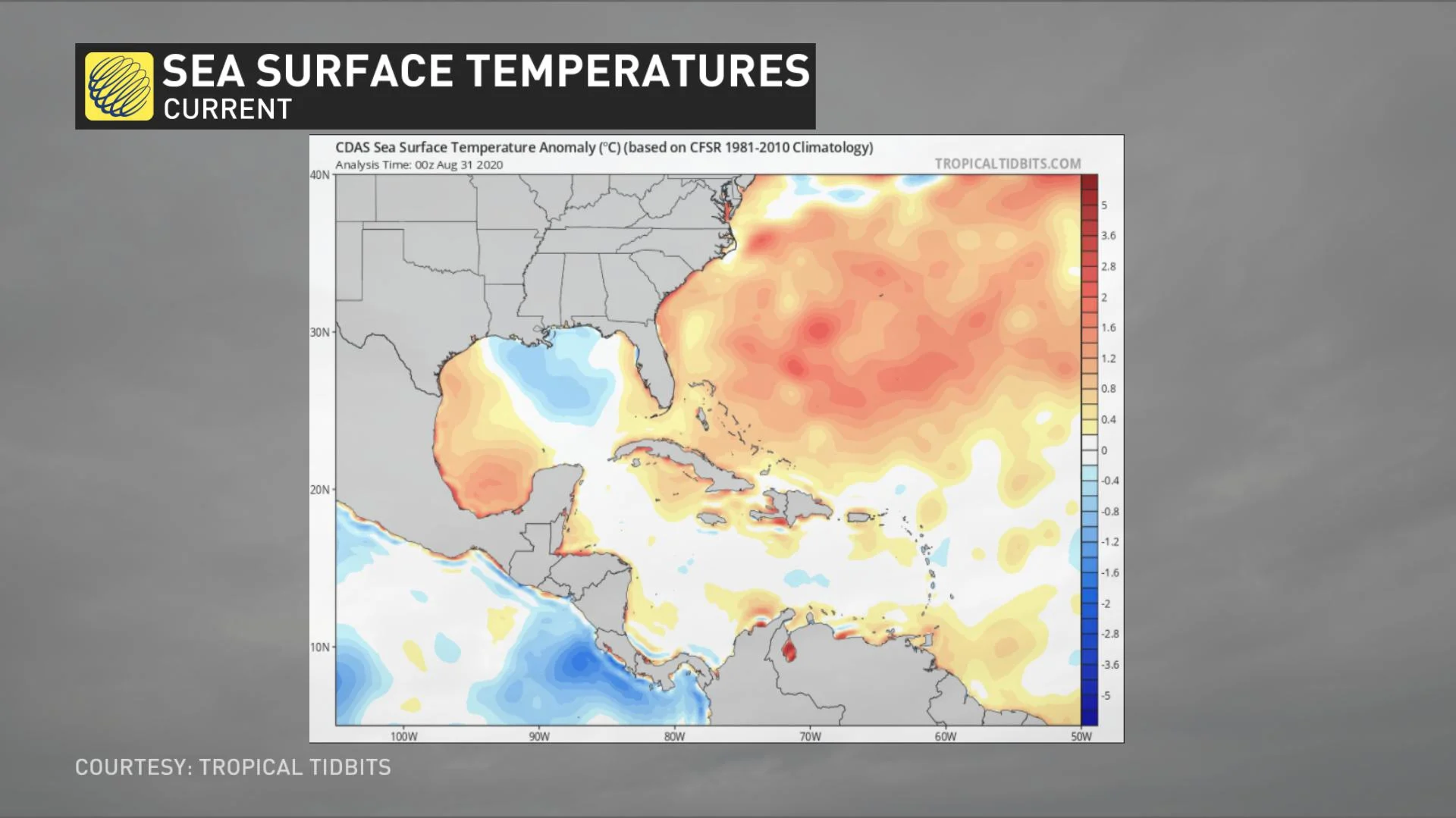
By this time of year, we have encountered peak summer heating, and the oceans are typically warmer than early months in the season. Warmer waters fuel tropical systems, allowing excessive rising motion over the water, resulting in strong thunderstorms that can become organized into tropical systems.
Another factor that comes into play is that we typically have less wind shear in the pattern this time of year. The Jet Stream is weaker in the summer months and wind shear fades through June and July, becoming almost non-existent in August and September. This is not a good thing, as wind shear can help weaken tropical systems.
ONE STORM FADES, EYES ON SEVERAL OTHER POTENTIAL SYSTEMS
As of Saturday morning, Tropical Depression Omar is still clinging to life, a few days after forming off the coast of the U.S., on a track that has been taking it well away from land.
The storm, the earliest 15th-named on record, is likely to become subtropical by Saturday night or early Sunday morning.
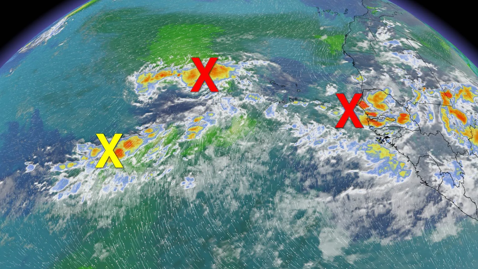
Elsewhere in the Atlantic, forecasters are keeping an eye on three other tropical disturbances closer to the coast of West Africa.
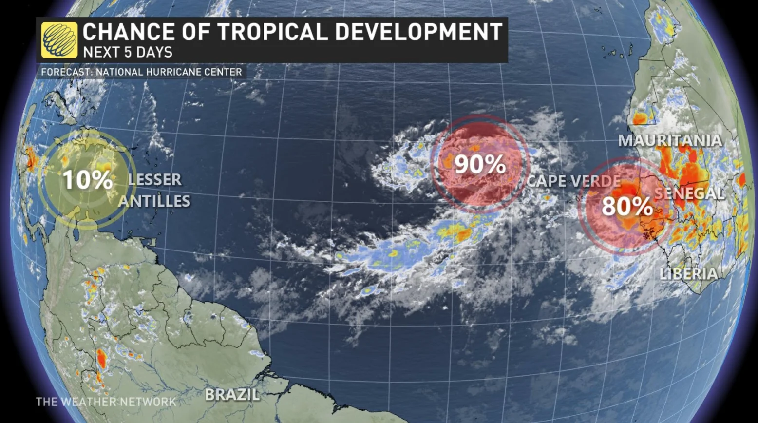
The first is a trough of low pressure located about midway between the west coast of Africa and the Windward Islands. Significant development of this system is not expected, as it will likely be hindered by the interaction with a large tropical wave located a hundreds of kilometres to its east. It only has a 10 per cent chance of development in the next five days.
Next is a tropical wave and area of low pressure located over the eastern tropical Atlantic, which is producing a large area of disorganized showers and thunderstorms. Gradual development of this system is expected while it moves westward to west-northwestward and a tropical depression is likely to form late this weekend or early next week. The possibility of development over the next five days has increased to 90 per cent.
As well, another tropical wave is forecast to move off the west coast of Africa on Sunday. Gradual development of this system is expected and a tropical depression is likely to form by the middle of next week. The chance of its development over the next five days is now at 80 per cent.


