PHOTOS: Atlantic Canada walloped by destructive 100+ km/h winds, snow

Atlantic Canada was battered by a powerful storm that brought heavy snow, frozen precipitation and damaging winds across the region Monday, leading to closures and cancellations, as well as reports of parts of roofs being whisked away from homes in Newfoundland.
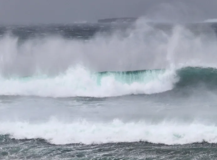
The intense low-pressure system gave significant snow and rain to New Brunswick and heavy rain and strong winds to Nova Scotia Monday, while delivering a blast of heavy snow and damaging winds to Newfoundland.
SEE ALSO: Ice jam along St. John River closes 3 Perth-Andover schools for Monday
It caused numerous power outages, school delays and cancellations, and disrupted travel across the region. In Newfoundland, Marine Atlantic's ferries were shut down Monday.
While parts of Newfoundland were forecast to get hit with 20-30 cm of snow, and some areas in New Brunswick received up to 20 cm, the much bigger story with the system was the damaging winds. Much of the region was blanketed with wind warnings.
St. Joseph du Moine, Grand Etang and Plateau, all on Cape Breton Island in Nova Scotia, saw violent wind gusts of 164 km/h, 159 km/h and 151 km/h, respectively. Other notable wind speeds were 108 km/h in Eskasoni First Nation and 102 km/h in Brier Island.
In Newfoundland, winds were forecast to reach gusts of 120 km/h along parts of the coast in central and eastern areas, and with as high as 150 km/h gusts possible for the Wreckhouse area, stretching north to Daniel's Harbour.
While conditions have improved in the Maritimes, winds will remain intense overnight Monday in Newfoundland, though weaker than earlier in the day, with gusts of 70-90 km/h expected for the coastal regions. They will keep diminishing into Tuesday morning, with widespread gusts of 60-70+ km/h still.
The island will also see sea-effect snow continue into Tuesday afternoon, with a short breather Wednesday before the next system moves in Thursday.
Below is a section of visuals from the damaging storm that made its way onto social media Monday.
Embedded content: controls="0">Thumbnail courtesy of Mark Gray, taken in Bonavista, N.L.


