PHOTOS: Wild tornado-warned storms take a toll in southern Ontario

Intense storms swept through southern Ontario on Tuesday, prompting tornado warnings in some areas and leaving damage in a number of regions due to the powerful winds that exceeded 100 km/h in many areas.
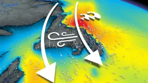
Powerful winds, torrential rainfall, and hail accompanied tornado warnings from Environment Canada as a cluster of storms tracked through the Huron-Perth and Grey-Bruce regions late Tuesday afternoon.
The severe storms then swept through the Greater Toronto Area (GTA) in the early evening hours, bringing wild winds, torrential rains, shelf clouds and frequent lightning, leaving many without power across the province. Hydro One reported that about 65,000 customers were in the dark at the height of the storm.
Atmospheric instability set the stage for severe weather as storms tracked out of Michigan and over the Great Lakes. Waterspouts were spotted on Lake Huron and a number of surrounding neighbourhoods near the shorelines witnessed chairs, fences, and other items being tossed in the wind. Dozens of downed trees have also been reported in areas such as Lucknow, Kingsbridge, Port Albert and Port Elgin.
The tornado warnings have since ended and there hasn't been any confirmation of one occurring at this time.
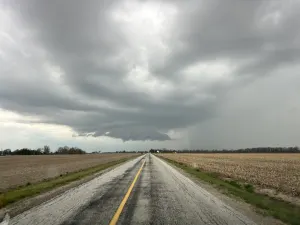
There were reports of toonie-sized hail and winds in excess of 100 km/h in many areas.
Visuals of the storms began to flood social media shortly after the storms started firing up. See below for a look at the impact the intense storms had on parts of southern Ontario.
SEVERE WEATHER STRIKES SOUTHWESTERN ONTARIO TUESDAY, POTENTIAL TORNADO
Thumbnail credit: MaryAnn Williams.