
Cars stranded, hours without power as potent snowstorm blasts the Prairies

A deep and powerful low-pressure system continues its trek eastward across Saskatchewan and Manitoba on Thursday, with drivers being warned to postpone any non-essential travel. Widespread winds in excess of 100 km/h have been reported, which combined with a swath of snow, have created dangerous whiteout conditions. The snow will gradually ease up in intensity across both provinces, but strong northwesterly winds are expected to continue, with blowing snow remaining a serious threat through much of Thursday. More on the timing and impact, below.
WEATHER HIGHLIGHTS:
Persistent winds causing whiteout conditions with blowing snow over southern Saskatchewan and Manitoba Thursday
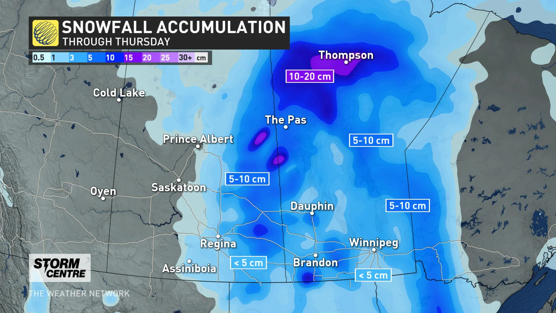
Parts of the southern Prairies will see up to 10 cm of snow, with a heavier swath of 10-20 cm over northern sections
System gradually departs Thursday night, temperatures trend closer to seasonal for eastern Prairies this weekend
THURSDAY: TRAVEL NOT RECOMMENDED AMID DANGEROUS BLOWING SNOW CONDITIONS
A powerful clipper system continues to impact parts of southern Saskatchewan and Manitoba through Thursday, after setting nine all-time wind records, and causing extensive damage in Alberta on Wednesday.
With the passage of the cold front, widespread winds upwards of 100 km/h have been reported, including a peak overnight gust of 143 km/h, recorded in Bratts Lake, Sask., late Wednesday night. A peak gust of 122 km/h was also reported at Regina International Airport.
The winds, combined with a swath of moderate snow and periods of freezing rain, have made for dangerous and near impossible travel conditions, with complete whiteouts shutting down numerous highways across both Saskatchewan and Mantioba. Several drivers were left stranded in their cars overnight on Wednesday due to the severe weather threats.
Drivers are being urged to just stay home until conditions improve.
A number of customers have been left in the dark throughout the region, with some residents reporting power outages of more than eight hours.
The poor conditions have also prompted several school and bus cancellations for Thursday.
SNOW GRADUALLY EASES WHILE WINDS PERSISTS
Parts of the Prairies are expected to see up to 10 cm of snow through Thursday, with a heavier swath of 10-20 cm over northern sections of Saskatchewan and Manitoba.
While the snow will gradually ease off in intensity through Thursday, strong northerly winds with gusts up to 100 km/h will persist for much of the day, with blowing snow remaining a major concern.
LONG RANGE OUTLOOK: FRIGID AIR FINALLY PLUNGES SOUTH
As this strong system departs the region later Thursday night, snow flurries and gusty winds will linger into Friday across southern Manitoba.
"Temperatures will trend closer to seasonal across southern Manitoba for the weekend, but very mild weather will continue to dominate across western parts of the region," says Weather Network meteorologist Dr. Doug Gillham.
The milder weather will continue for the first half of next week as well, with another clipper system expected to track southeast from northern Alberta to southern Saskatchewan.
"Arctic air will then plunge south into western parts of the Prairies around Wednesday or Thursday and continue to spread eastwards," Gillham says, adding that it will be a frigid end to January, with a much colder pattern expected to dominate through February as well.
UPDATED: Don't write off winter, Canada. Updated January outlook signals major changes
Thumbnail image courtesy: Darren Yankow