Massive, fire-triggered thunderstorms becoming more common
Scientists are concerned the frequency of pyrocumulonimbus clouds is increasing
After several years worth of worsening wildfire seasons, many Canadians are already coming to terms with the fact that more intense, more frequent wildfires will come hand in hand with a changing climate. Fire and fire weather scientists are now cautioning that a rise in the number of massive, fire-driven thunderstorms -- pyrocumulonimbus clouds -- may be another consequence of these more intense fires.
Visit our Complete Guide to Spring 2019 for an in depth look at the Spring Forecast, tips to plan for it and much more
Mike Flannigan, the director of the Canadian Partnership for Wildland Fire Science at the University of Alberta, told Yale Environment 360, more intense fires with more vigorous plumes of smoke, black carbon, and water vapor all incresae the likelihood of pyrocumulonimbus clouds (or 'pyroCbs'). And those are the precisely the kinds of fires that seem to be on the rise.
(RELATED: Canada in 2030 - Frequent, more intense wildfires)
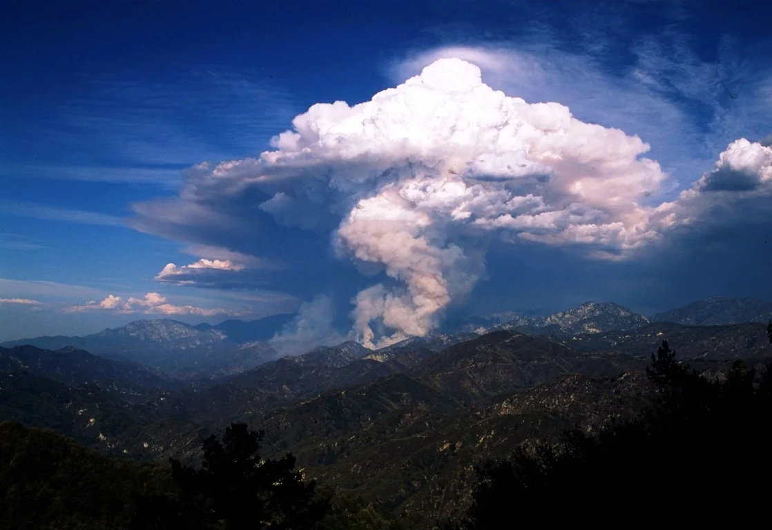
While it might sound like a positive thing -- a thunderhead forming over a fire -- these clouds don't produce rain that might help to quell the blaze, but rather are dry storms that typically feature intense lightning and no rain. They've also made headlines in the past few years for forming fire whirls that can produce tornado-strength winds.
Scientists have also found that these massive PyroCbs are capable of producing an effect similar to that of a major volcanic eruption. Smoke and aerosols from the wildfires can be injected into the stratosphere, where they can remain suspended for months scattering a great deal of solar radiation, and thus producing a cooling effect. Think of a cooling effect similar to the one produced by the eruption of Mount Pinatubo back in 1991 which caused a global temperature drop of 0.6°C for 15 months.
WATCH BELOW: 'FIRE-NADO' RAGES IN CALIFORNIA'S CARR FIRE
Flannigan said that sending in ground crews to fight pyroCb fires is often impossible, as the fires can be "extremely hot and chaotic," with embers shooting in all directions, sometimes as far as three miles (4.8 km).
(SEE ALSO: Future looks 'grim' for B.C. wildfires)
WHAT CAUSES A PYROCB?
The specific mecahnism behind a pyrocumulonimbus cloud is not entirely understood by scientists. We do know that pockets of rising air -- intense updrafts -- form in the super-heated air above the fire, sucking in smoke, ash, burning material, and water vapour and drawing them high into the air. The resulting cloud looks a lot like a classic thunderstorm, but the combination of the heat and particulate matter in the smoke trigger a reaction that prevents the cloud from producing rain. That leaves a lightning-filled storm to spark additional fires in the surrounding area; which is exactly what happened in Fort McMurray in 2016.
Apart from the immediate danger of the storm, both to fire crews and to those threatened by erratically spreading fires, a recent study showed that the storms can pack as much energy and impact as "moderate-sized volcanic eruptions," as they push ash and smoke high into the atmosphere. In 2017, scientists as far away as Ellesmere Island and Greenland found traces of chemicals believed to have been shot into the stratosphere by pyroCbs that formed in the year's ferocious wildfire season in B.C. and Washington.
MORE PYROCBS? OR ARE WE JUST GETTING BETTER AT SPOTTING THEM?
While no one knows for sure that they are, pyroCbs appear to be increasing in number in recent years. According to the release, researchers say they are now documenting an average of 25 single-pyroCb events a year in western North America.
(RELATED: How climate change is fueling California's wildfires)
One of Fromm's main concerns is that, while a single pyroCb happening with major fires may not have the climate-influencing power of a major volanic eruption, but several 'clusters' per year -- like the ones that happened in 2017 -- might.
"Figuratively, we have a map pinpointing the location of pyroCbs events," sayid Mike Fromm, a meteorologist at the U.S. Naval Research Laboratory. "It’s been filling up fast. Maybe we’re better at detecting them, but I think they’re increasing."
Tune in to full episodes of CAPTURED on The Weather Network, Sunday November 24 and Sunday December 1 at 7pm and 10pm ET & PT.
Sources: Yale Environment | Thumbnail courtesy JeremyaGreene/Creative Commons