
Mighty low packed with abundant moisture saturates Ontario, Quebec

After a long stretch of unseasonable warmth in southern Ontario -- for the first half of October -- temperatures are set to tumble this weekend with cooler air being ushered in along with the leftover rainfall from a potent system that contained the remnants of what was Hurricane Pamela. Most of the heaviest precipitation will be centred in eastern Ontario and Quebec Saturday, where some areas of the latter may see 50+ mm, the Great Lakes region could see some more unsettled weather into Sunday. What to expect with what's left of the rain for southern Ontario and what's ahead for eastern areas of the province and Quebec, below.
Visit our Complete Guide to Fall 2021 for an in-depth look at the Fall Forecast, tips to plan for it and much more!
SATURDAY/SUNDAY: HEAVY RAIN PUSHES EAST, SUMMER-LIKE WARMTH DISAPPEARS
Widespread special weather statements are in place for the heavy rainfall in southern and eastern Ontario on Saturday morning -- courtesy of a system with origins that was once Hurricane Pamela in the Pacific Ocean.
"If visibility is reduce while driving, turn on your lights and maintain a safe following distance. Heavy downpours can cause water pooling on roads," Environment and Climate Change Canada said in the statement.
The heaviest system rain will continue through Saturday for eastern areas and across southern Quebec, while the GTA and southwestern sections of the former have experienced the worst of it.
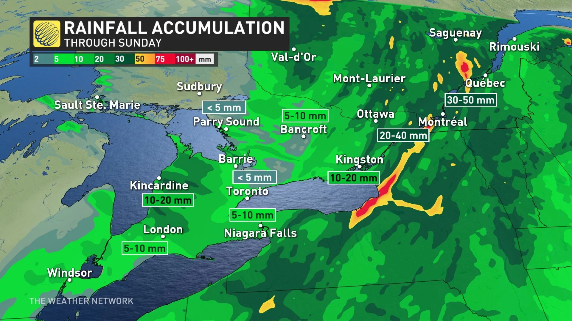
Rainfall amounts will be heaviest in eastern Ontario and Quebec, as the bulk of the precipitation shifts into these regions through Sunday. Some areas in the latter may see 50+ mm of rainfall, with 20-40 mm for southern Quebec and portions of eastern Ontario.
In Ontario, a strong northwestern flow over the Great Lakes will usher in some Arctic air, cool enough to trigger some lake-effect showers Saturday night and Sunday.
Temperatures will remain cool for the remainder of the weekend in Central Canada. Daytime highs will stay in the teens for both days in southern Ontario, with upper-end values for eastern areas and into the low 20s for parts of southern Quebec Saturday before dropping off Sunday.
NEXT WEEK: WARMER CONDITIONS MAKE A BRIEF RETURN
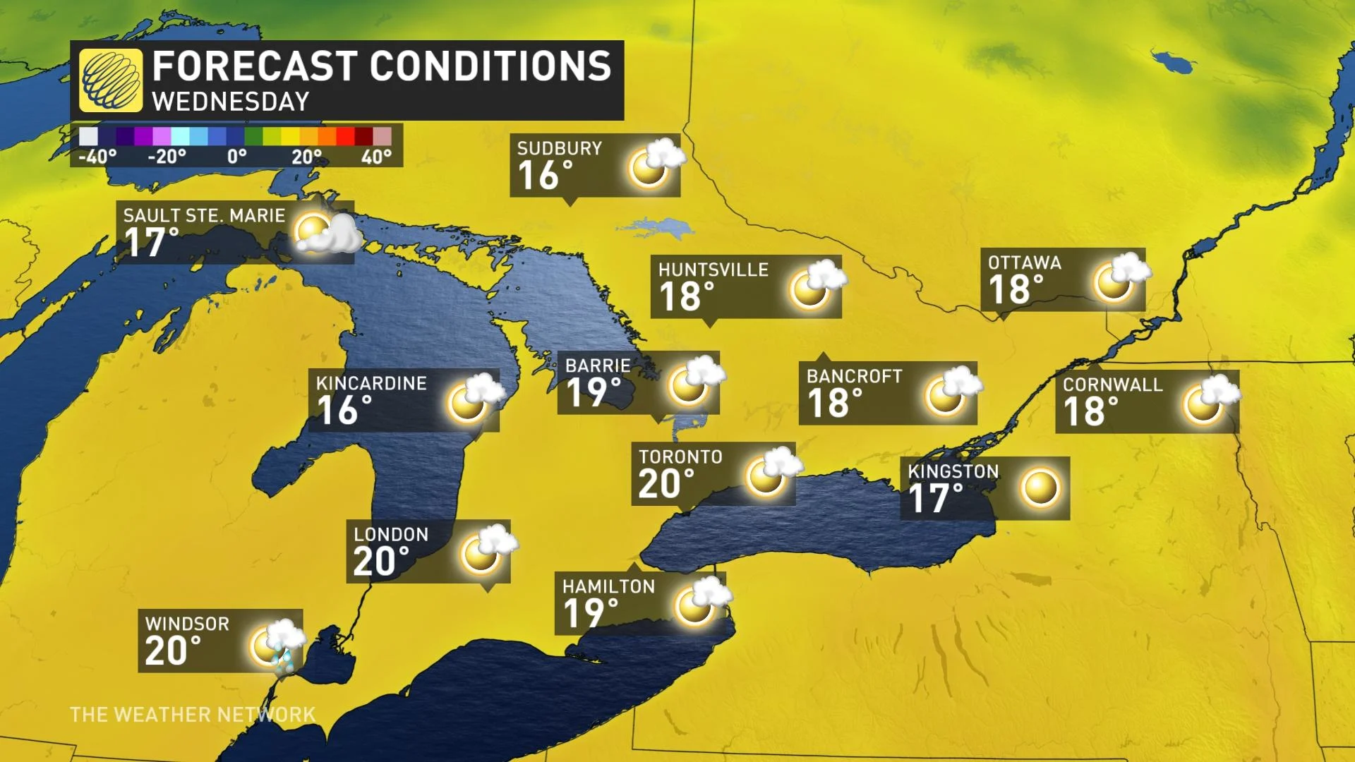
Despite the weekend drop in temperatures, all hope is not lost. High pressure will fight back to start next week and will clear the skies, also driving temperatures back to the 20°C by Tuesday.
The warmth won't be sticking around for long this time, however, with conditions turning colder later in the week once again.
"We're watching the potential for much colder weather late week and weekend, and possibly our first lake-effect flakes of the season for parts of the snow-belt regions, especially across higher terrain," says Dr. Doug Gillham, a meteorologist at The Weather Network.
Overall, a more changeable pattern is expected for the second half of October, but temperatures will still tip to the warm side of seasonal.
Be sure to check back for the latest updates on the incoming soggy system in Ontario.