Storm threat builds in Alberta as heat, smoke plague Western Canada

The heat wave currently impacting Western Canada is not as intense and won't be as long as the record-breaking event in late June. But temperatures will still hot enough that, when combined with the wildfire smoke from B.C., can make for uncomfortable days and sleeping conditions at night. Some of the current heat warnings in effect in the West may continue past the long weekend, potentially hanging around until mid-week. Tuesday sees a severe storm potential bubble up in parts of Alberta. Beyond, a pattern change is looming for next weekend, allowing for the smoke to clear and temperatures to drop considerably on the Prairies. More on the heat, smoke, and storm threat, below.
TUESDAY: HEAT HANGS OVER THE PRAIRIES, SEVERE STORM RISK POPS UP IN ALBERTA
The heat is forecast to persist through the week on the Prairies. However, temperatures will moderate in most of northern and east-central Alberta on Tuesday.
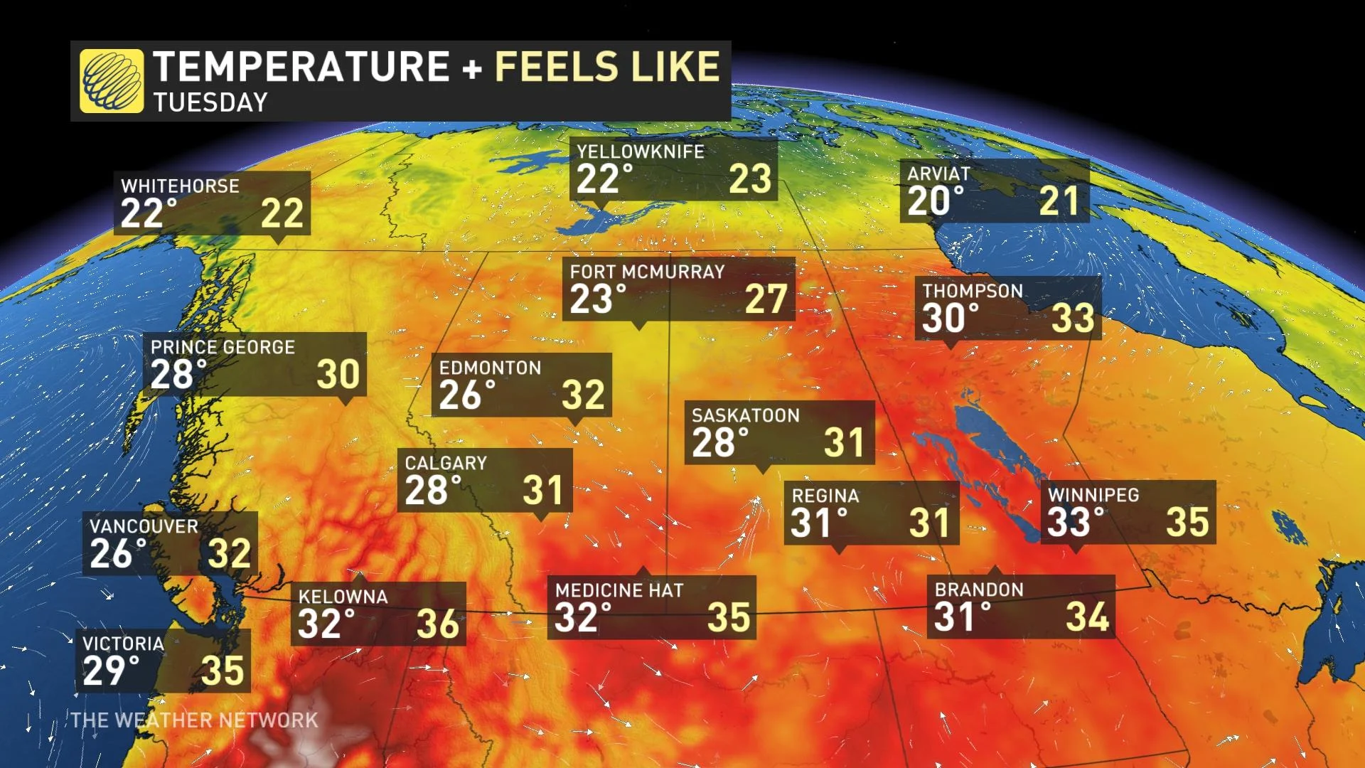
The hottest temperatures are expected on southern areas of the Prairies and B.C., where daytime highs could reach the low- to mid-30s. Heat warnings remain in place for a good portion of Alberta and Saskatchewan, and portions of B.C. and Manitoba, as well.
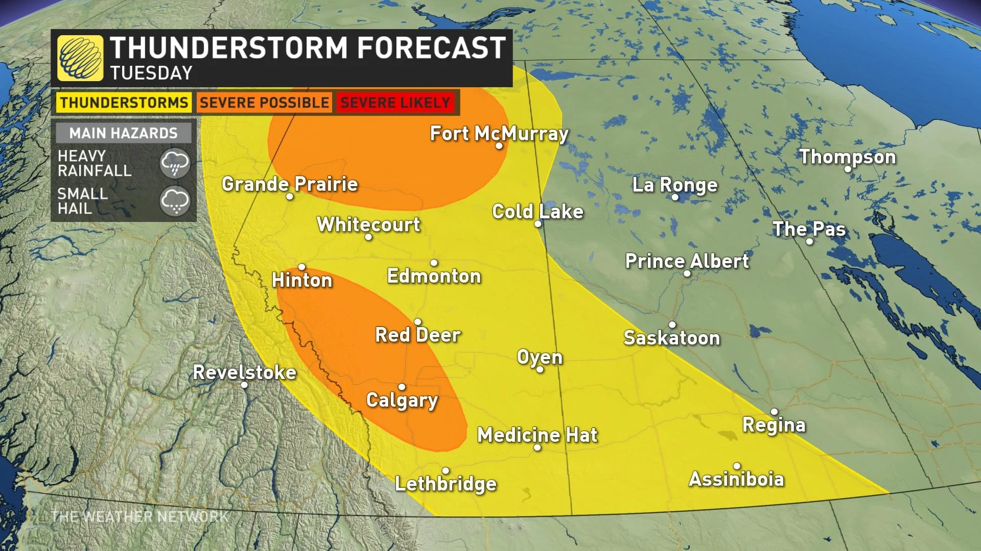
In addition to the hot temperatures, the threat for thunderstorms will pop up again Tuesday afternoon, thanks to instability with a shortwave trough. Storms are likely to fire up on the backside of the ridge. The risk areas will stretch from northeastern B.C. to southern Saskatchewan.
There is also the potential for some of the storms to turn severe, with areas along the foothills including Calgary and in the northern half of the province at greatest risk. The main hazards will be heavy rainfall and small hail.
Meanwhile, the ongoing wildfires in B.C. are causing air quality to deteriorate in the province. Some areas are experiencing very unhealthy or even hazardous levels.
Air quality is also poor is Saskatchewan, resulting from wildfire smoke scattered across central areas. It is causing reduced visibility at times near and downwind from these fires over central and east-central sections. Northeast winds developing Tuesday will push this smoke southward into the northern grainbelt, leading to poor air quality for this region, as well.
THE WEEK AHEAD: THE HEAT STICKS AROUND, BUT RELIEF IS IN SIGHT
The ridge responsible for this weekend’s warmth will slowly break down, allowing for temperatures to return closer to seasonal across much of British Columbia. An approaching trough could bring a chance for showers and thunderstorms later in the week.
"The next pattern change will see an upper-level low by next weekend mix out much of the smoke in the atmosphere, and will drop temperatures drastically. Some by the end of the seven-day period might question where summer has gone, with daytime highs only into the teens for parts of the Prairies," said Jaclyn Whittal, Storm Hunter and meteorologist at The Weather Network.
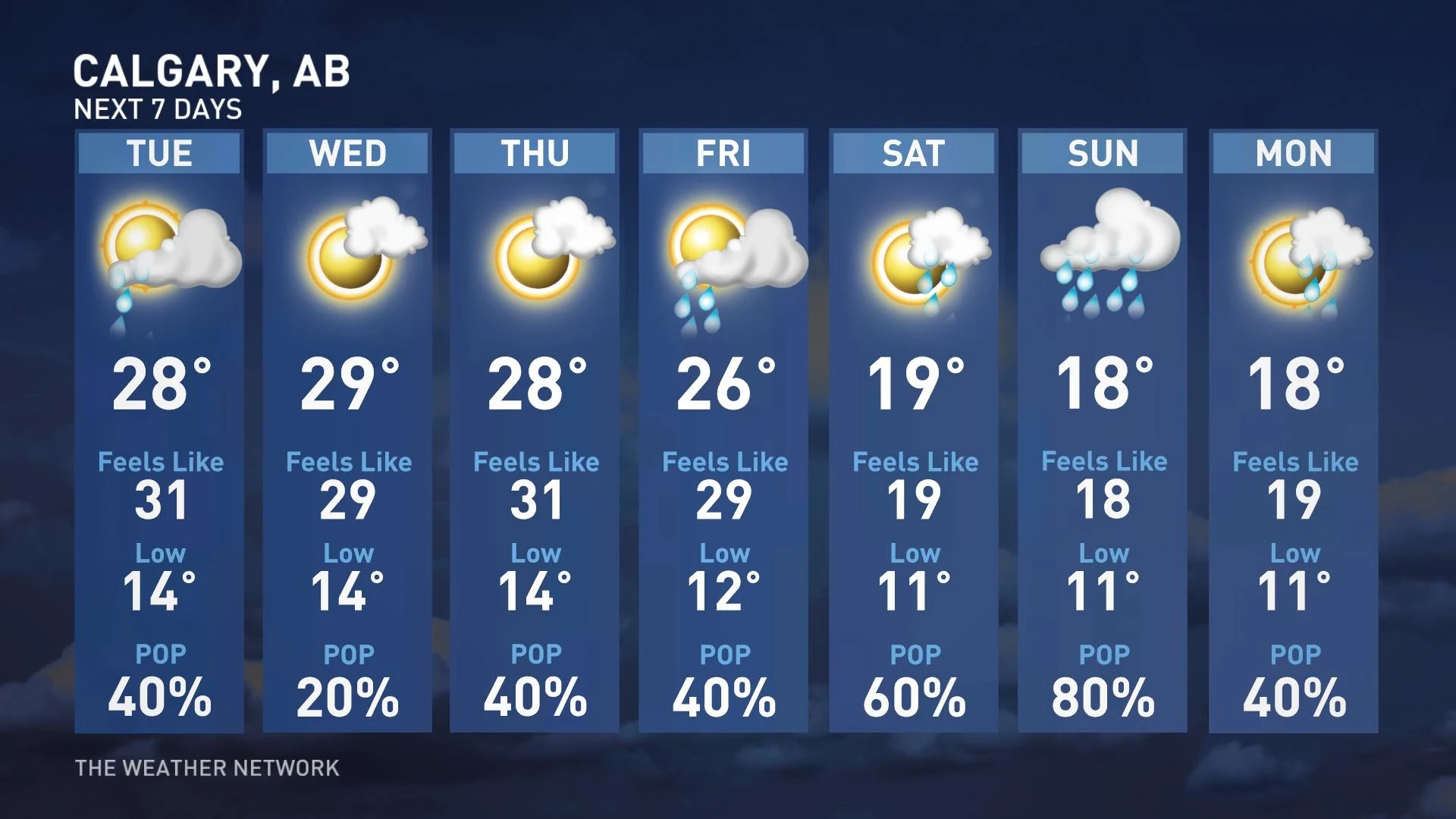
Temperatures will remain above-seasonal on much of the Prairies through the coming week, though we could finally see some relief from the heat by this weekend.
Check back for the latest forecast across Western Canada.


