7 twisters confirmed in June 10 tornado outbreak

Northern Tornadoes Project has confirmed two more touchdowns from the June 10 storms in Ontario, bringing the total to seven so far, classifying it as an outbreak.
The Northern Tornadoes Project has now confirmed two additional touchdowns from the June 10 storms in Ontario, bringing the total to seven so far. With the verification, the event is considered a tornado outbreak.
The newest ones added to the tally include twisters in Belgrave and Brussels, both rated EF-0 by researchers from the Western University-based project.
The Belgrave tornado, which touched down at 5:45 p.m. EDT, had a path of 5.5 kilometres in length, with damage incurred to trees and farm hutches. Its winds speeds were 90 km/h. The Brussels twister, touched down at 6 p.m. EDT and had a path of 3.1 kilometres in length, also with 90 km/ winds, causing damage to trees.
The seven tornadoes were identified at different dates -- Belmont on June 11, Newbury on June 12, Bracebridge, Baysville, Mary Lake on June 18 and Belgrave and Brussels on June 24. An outbreak is considered to feature at least 6 tornadoes spawned from the same synoptic-scale weather system.
RELATED: Could a tornado outbreak sweep through Ontario again?
TIMELINE OF JUNE 10 TORNADO TOUCHDOWNS AND RATINGS
Belgrave: Touched down at 5:45 p.m. EDT, had a path of 5.5 kilometres in length, with damage incurred to trees and farm hutches. Its winds speeds were 90 km/h. Rated EF-0.
Brussels: Touched down at 6 p.m. EDT and had a path of 3.1 kilometres in length, with 90 km/ winds, causing damage to trees. Rated EF-0.
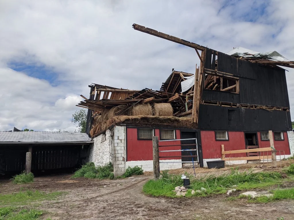
Bracebridge: Touched down at 7:30 p.m. EDT and had a path of 5.6 kilometres in length, with 150 km/h winds, causing structural and tree damage. Rated EF-1.
Mary Lake: Touched down at 7:45 p.m. EDT and had a path of 24.6 kilometres in length, with 190 km/h winds, causing structural and tree damage. Rated EF-2.
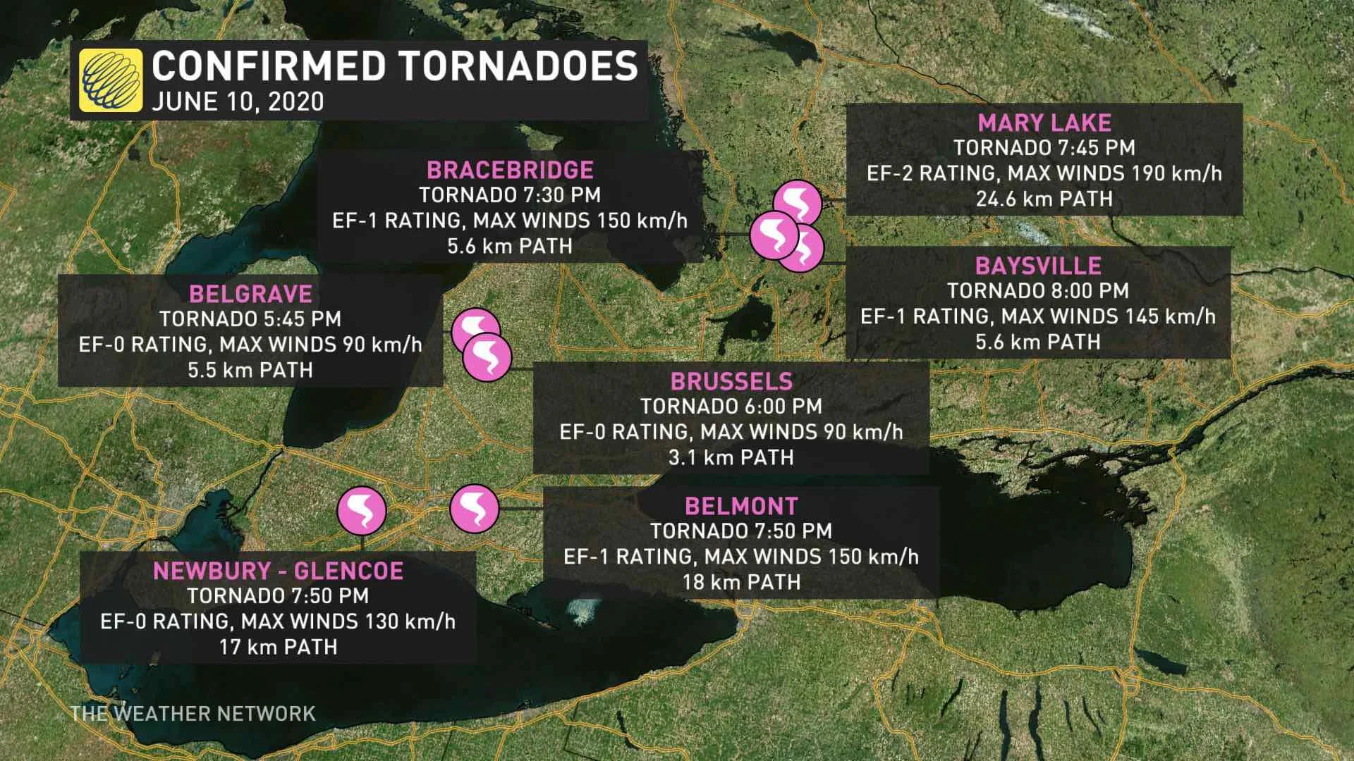
Newbury: Touched down at 7:50 p.m. EDT and had a path of 17 kilometres in length, with 130 km/h winds, causing structural and tree damaged. Rated EF-0.
Belmont: Touched down at 7:50 p.m. EDT and had a path of 18 kilometres in length, with 150 km/h winds, causing structural and tree damage. Rated EF-1.
Baysville: Touched down at 8 p.m. EDT and had a path of 5.6 kilometres in length, with 145 km/h winds, causing tree damage. Rated EF-1.
'THE WHOLE HOUSE SHOOK,' TORNADO CLEANUP BEGINS IN BELMONT
HOW COMMON ARE TORNADO OUTBREAKS?
Despite the June 10 outbreak, these types of multiple tornado events are infrequent in the province, recently stated by Weather Network Storm Hunter and meteorologist Mark Robinson.
He did acknowledge the province can see outbreaks similar to those in Tornado Alley, but quickly pointed out they're not common in Ontario, indicative by the amount of time passed in between them.
"All you need is a tremendous amount of energy in the atmosphere, plus a good amount of wind shear. Put those two things together, with a trigger, and you absolutely can have an outbreak," said Robinson.
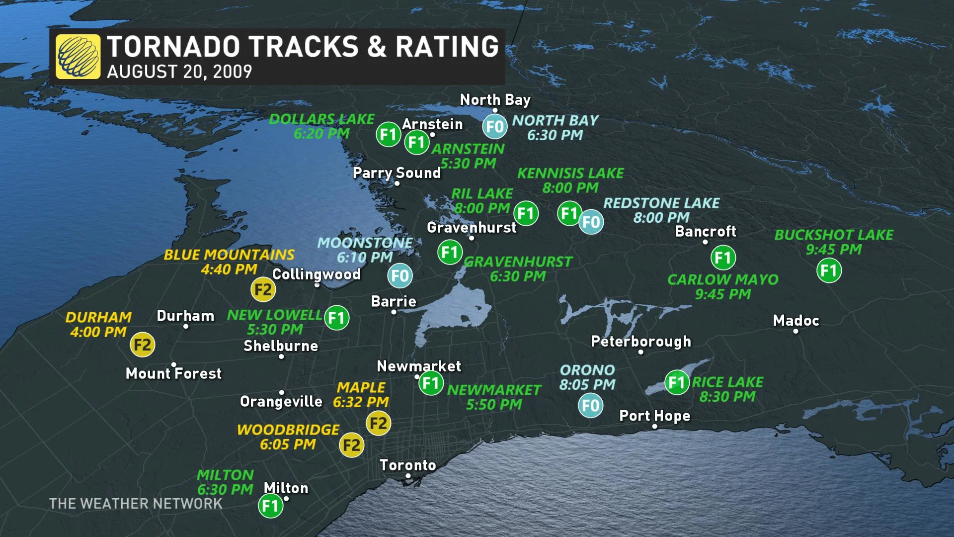
Perhaps the province's most notable outbreaks occurred on May 31, 1985, Aug. 2, 2006 and Aug. 20, 2009. All three events featured more than 10 tornadoes touching down - 14, 17 and 19, respectively. The latter was the largest single-day outbreak in the province's history.
As well, two of those three outbreaks featured fatalities, with the death toll reaching 16 in the 1985 event, while one person was killed on Aug. 20, 2009.
Ontario is also not immune to the threat of destructive twisters, as well, says fellow Storm Hunter and Weather Network meteorologist Jaclyn Whittal.
"While statistically it is rare for this area to get destructive EF-4 or EF-5 tornadoes, it could happen," the veteran Storm Hunter said. "There is no meteorological reason why it couldn't happen again in Ontario like we saw in 1985."
CAN ONTARIO EXPERIENCE TORNADO OUTBREAKS LIKE TORNADO ALLEY IN THE U.S.?
Thumbnail courtesy of Marta Czurylowicz.