Active Alerts Mesa, CO
You should monitor later forecasts and be prepared to take actionshould Flash Flood Warnings be issued.
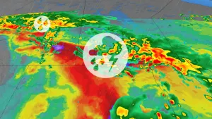
* WHAT...Flash flooding caused by excessive rainfall continues to bepossible.* WHERE...Portions of Colorado, including the following areas,Animas River Basin, Central Colorado River Basin, Central Gunnisonand Uncompahgre River Basin, Central Yampa River Basin, Debeque toSilt Corridor, Elkhead and Park Mountains, Flat Tops, FourCorners/Upper Dolores River, Gore and Elk Mountains/CentralMountain Valleys, Grand Valley, Grand and Battlement Mesas, LowerYampa River Basin, Northwest San Juan Mountains, ParadoxValley/Lower Dolores River, Roan and Tavaputs Plateaus, San JuanRiver Basin, Southwest San Juan Mountains, Uncompahgre Plateau andDallas Divide, Upper Gunnison River Valley, Upper Yampa RiverBasin and West Elk and Sawatch Mountains and Utah, including thefollowing areas, Arches/Grand Flat, Canyonlands/Natural Bridges,La Sal and Abajo Mountains, Southeast Utah and Tavaputs Plateau.* WHEN...From noon MDT today through this evening.* IMPACTS...Excessive runoff may result in flooding of rivers,creeks, streams, and other low-lying and flood-prone locations.Flooding may occur in poor drainage and urban areas. Low-watercrossings may become flooded.* ADDITIONAL DETAILS...- A strong surge of subtropical moisture combined with a weakupper level disturbance raises the potential for excessiverainfall across the region. Though storms will not be slowmoving, training echoes and rainfall rates in excess of 2inches per hour are possible. Slick rock areas, slot canyonsand burn scars are at greatest risk, but urban flooding isalso a concern.- http://www.weather.gov/safety/flood