Active Alerts Andres, IL
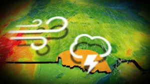
Strong west winds with gusts as high as 50 mph will move acrossthe greater Chicago metropolitan area over the next few hours as acomplex of thunderstorms moves across northern Illinois. Thewinds may begin well before rain arrives, and continue for greaterthan 30 minutes at any given location.In addition, locally stronger winds in excess of 60 mph may occurwhere thunderstorms are strongest of intensify. In thesesituations, Severe Thunderstorm Warnings will be issued.Consider moving indoors until the gusty winds andthunderstorms pass.
The Illinois Environmental Protection Agency has issued an AirPollution Action Day for Monday June 17th for the greater ChicagoMetropolitan Area through Monday night.A Chicago area Air Pollution Action Day is declared when weatherconditions are such that widespread ozone and or particulate levelsare expected to be at or above the Unhealthy for Sensitive Groupscategory of the Air Quality Index for multiple days.Active children and adults, especially people with pulmonary orrespiratory disease such as asthma, should limit prolonged outdooractivity.Area residents are urged to reduce pollution levels. Air qualityforecasts, current air quality, and tips on how you can reduce youremissions can be found at www.airnow.govmedia contact...217 558 1536.
Blowing dust brings reduced visibility, leading to dangerous drivingconditions. If driving, avoid blowing dust if possible. If caught indense blowing dust, pull off the road, turn off your lights and keepyour foot off the brake.
The National Weather Service in Chicago has issued a* Dust Advisory for...Kendall County in northeastern Illinois...Southeastern La Salle County in north central Illinois...Western Will County in northeastern Illinois...Southeastern De Kalb County in north central Illinois...Grundy County in northeastern Illinois...Kane County in northeastern Illinois...* Until 545 PM CDT.* At 439 PM CDT, the leading edge of strong thunderstorm outflowwinds resulting in blowing dust along a line extending from nearSt. Charles to near Yorkville to near Marseilles, moving east at40 mph.HAZARD...Localized visibility down below one half mile,particularly in open and rural areas.SOURCE...Doppler radar.IMPACT...Hazardous travel.Including the following interstates...I-39 between mile markers 43 and 46.I-55 between mile markers 219 and 263.I-80 between mile markers 89 and 131.I-88 between mile markers 102 and 120.I-90 between mile markers 42 and 57.Locations impacted include...Aurora, Joliet, Naperville, Elgin, Bolingbrook, Bartlett, Romeoville,Plainfield, Carpentersville, St. Charles, Oswego, Algonquin, WestChicago, Batavia, Huntley, Geneva, Ottawa, Yorkville, Streator,Morris, Channahon, Campton Hills, Minooka, Plano, and Sandwich.This includes... Aurora University, Channahon State Park, ElginCommunity College, Fermilab, Gebhard Woods State Park, Grundy CountySpeedway and Fairgrounds, IL Math and Science Academy, Illini StatePark, Joliet Junior College, Kane County Cougars Ballpark, WaubonseeCommunity College, and William G Stratton State Park.