Active Alerts Brookline, MA
Turn around, don't drown when encountering flooded roads. Most flooddeaths occur in vehicles.
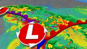
At 926 PM EDT, Doppler radar indicated thunderstorms producing heavyrain. A trained spotter reported that the portion of Route 9 wasflooded up to one foot in Natick. Between 1 and 2 inches of rainhave fallen. The expected rainfall rate is 0.5 to 1.5 inches in 1hour. Additional rainfall amounts of 1 to 2 inches are possible inthe warned area. Flash flooding is already occurring.HAZARD...Flash flooding caused by thunderstorms.SOURCE...Radar.IMPACT...Flash flooding of small creeks and streams, urban areas,highways, streets and underpasses as well as other poordrainage and low-lying areas.Some locations that will experience flash flooding include...Boston, Cambridge, Quincy, Newton, Somerville, Framingham,Waltham, Brookline, Medford, Revere, Arlington, Everett,Marlborough, Chelsea, Natick, Watertown, Needham, Wellesley,Dedham and Belmont.