Active Alerts Bigelow, MO
Turn around, don't drown when encountering flooded roads. Most flooddeaths occur in vehicles.Caution is urged when walking near riverbanks.Additional information is available at water.noaa.gov.
...The Flood Warning is extended for the following rivers inNebraska...Iowa...Missouri...Missouri River At Decatur affecting Burt, Monona and ThurstonCounties.Missouri River At Rulo affecting Holt and Richardson Counties.Missouri River At Nebraska City affecting Otoe and FremontCounties.Missouri River At Brownville affecting Nemaha and AtchisonCounties.Missouri River at Plattsmouth affecting Mills and Cass Counties.Missouri River At Omaha affecting Pottawattamie, Sarpy andDouglas Counties.Missouri River Near Blair affecting Pottawattamie, Harrison andWashington Counties.* WHAT...Minor flooding is occurring and moderate flooding isforecast.* WHERE...Missouri River at Rulo.* WHEN...Until Friday, July 05.* ADDITIONAL DETAILS...- At 9:45 AM CDT Friday the stage was 20.8 feet...or 3.8 feetabove flood stage.- Bankfull stage is 17.0 feet.- Recent Activity...The maximum river stage in the last 24hours was 20.8 feet.- Forecast...The river is expected to rise to a crest of 23.8feet early Tuesday morning. It will then fall below floodstage Friday, July 05.- Flood stage is 17.0 feet.
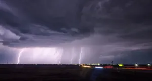
If outdoors, consider seeking shelter inside a building.A Tornado Watch remains in effect until 1100 PM CDT for northwesternMissouri.
At 849 PM CDT, Doppler radar was tracking a strong thunderstorm nearFairfax, or 10 miles southwest of Tarkio, moving east at 20 mph.HAZARD...Wind gusts up to 50 mph and nickel size hail.SOURCE...Radar indicated.IMPACT...Gusty winds could knock down tree limbs and blow aroundunsecured objects. Minor hail damage to vegetation ispossible.Locations impacted include...Tarkio, Rock Port, Fairfax, Craig, and Corning.This includes Interstate 29 between mile markers 89 and 111.