Active Alerts Beclabito, NM
If threatening weather approaches your area, take shelter in a sturdybuilding.Frequent dangerous cloud to ground lightning is occurring with thisstorm. Lightning can strike 10 miles away from a thunderstorm. Seek asafe shelter inside a building or vehicle.Motorists can expect brief but sudden changes in visibility andponding of water on highways as storms move through the area.
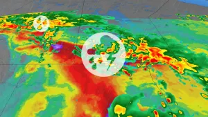
At 214 PM MDT, Doppler radar was tracking a strong thunderstorm 8miles northeast of Kirtland, or 9 miles northwest of Farmington,moving east at 20 mph.HAZARD...Wind gusts of 50 to 55 mph and penny size hail.SOURCE...Radar indicated.IMPACT...Gusty winds could knock down tree limbs and blow aroundunsecured objects. Minor hail damage to vegetation ispossible.Locations impacted include...Farmington, Aztec, Kirtland, Flora Vista, Upper Fruitland, and LaPlata.