Active Alerts McCord Place, NM
You should monitor later forecasts and be prepared to take actionshould Flash Flood Warnings be issued.
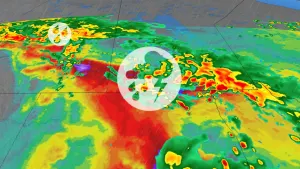
* WHAT...Flash flooding caused by excessive rainfall continues to bepossible.* WHERE...Portions of central, east central, north central,northeast, northwest, and west central New Mexico, including thefollowing areas, in central New Mexico, Central Highlands, EasternLincoln County, Estancia Valley, Lower Rio Grande Valley, MiddleRio Grande Valley including the Albuquerque Metro Area, Sandia andManzano Mountains including Edgewood, South Central Highlands andSouth Central Mountains. In east central New Mexico, GuadalupeCounty. In north central New Mexico, East Slopes Sangre de CristoMountains, Espanola Valley, Glorieta Mesa Including Glorieta Pass,Jemez Mountains, Northern Sangre de Cristo Mountains, NorthwestHighlands, Santa Fe Metro Area, Southern Sangre de CristoMountains and Upper Rio Grande Valley. In northeast New Mexico,Northeast Highlands. In northwest New Mexico, Chuska Mountains andNorthwest Plateau. In west central New Mexico, West CentralHighlands, West Central Mountains and West Central Plateau.* WHEN...Until midnight MDT tonight.* IMPACTS...Excessive runoff may result in flooding of rivers,creeks, streams, and other low-lying and flood-prone locations.* ADDITIONAL DETAILS...- - Torrential rainfall rates in excess of 2 inches per hourwillcreate rapid runoff that can quickly produce flash flooding.Urban drainages and areas with recent heavy rainfall will bemore susceptible to flash flooding.- http://www.weather.gov/safety/flood
If threatening weather approaches your area, take shelter in a sturdybuilding.Frequent dangerous cloud to ground lightning is occurring with thesestorms. Lightning can strike 10 miles away from a thunderstorm. Seeka safe shelter inside a building or vehicle.
At 246 PM MDT, Doppler radar was tracking strong thunderstorms alonga line extending from 20 miles south of Pueblo Pintado to 9 mileswest of Acoma Pueblo. Movement was east at 35 mph.HAZARD...Wind gusts of 50 to 55 mph and pea size hail.SOURCE...Radar indicated.IMPACT...Gusty winds could knock down tree limbs and blow aroundunsecured objects. Minor hail damage to vegetation ispossible.Locations impacted include...Grants, Laguna Pueblo, Acoma Pueblo, Cubero, Cebolletita, Mesita,McCartys, Marquez, Skyline-Ganipa, and New Laguna.