Active Alerts Orange, TX
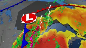
...The Flood Warning continues for the following rivers inLouisiana...Texas...Sabine River Near DeweyvilleAdditional information is available at www.weather.gov.The next statement will be issued Tuesday evening at 845 PM CDT.* WHAT...Minor flooding is occurring and minor flooding is forecast.* WHERE...Sabine River near Deweyville.* WHEN...Until further notice.* IMPACTS...At 26.0 feet, Moderate lowland flooding will occur. Thelowest homes between Deweyville and the river begin to flood,especially in the Indian Lakes and River Oaks sections. Low-lyingroads and a few homes in Southwestern Beauregard Parish have someflooding.* ADDITIONAL DETAILS...- At 7:45 PM CDT Monday the stage was 25.6 feet.- Recent Activity...The maximum river stage in the 24 hoursending at 7:45 PM CDT Monday was 25.8 feet.- Forecast...The river is expected to fall to 24.6 feetSaturday evening.- Flood stage is 24.0 feet.- http://www.weather.gov/safety/flood
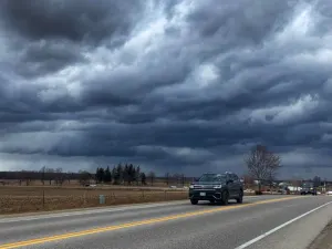
If travel is required, allow extra time as some roads may beclosed. Do not drive around barricades or through water ofunknown depth. Take the necessary actions to protect flood-proneproperty.
* WHAT...Minor coastal flooding.* WHERE...In Louisiana, Southern Calcasieu Parish. In Texas,Southern Orange County.* WHEN...Until 7 AM CDT Thursday.* IMPACTS...Flooding of lots, parks, and roads with onlyisolated road closures expected.* ADDITIONAL DETAILS...Tides will be around 1 foot above predictedastronomical levels, with actual tide levels during high tidetime between 1.0 and 1.5 MHHW.