Active Alerts West University Place, TX
You should monitor later forecasts and be prepared to take actionshould Flash Flood Warnings be issued.
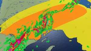
* WHAT...Flash flooding caused by excessive rainfall continues to bepossible.* WHERE...Portions of south central and southeast Texas, includingthe following areas, in south central Texas, Coastal Jackson andInland Jackson. In southeast Texas, Austin, Bolivar Peninsula,Brazoria Islands, Chambers, Coastal Brazoria, Coastal Galveston,Coastal Harris, Coastal Matagorda, Colorado, Fort Bend, GalvestonIsland, Inland Brazoria, Inland Galveston, Inland Harris, InlandMatagorda, Matagorda Islands, Southern Liberty, Waller, Washingtonand Wharton.* WHEN...From this evening through late Wednesday night.* IMPACTS...Excessive runoff may result in flooding of rivers,creeks, streams, and other low-lying and flood-prone locations.Creeks and streams may rise out of their banks. Flooding may occurin poor drainage and urban areas.* ADDITIONAL DETAILS...- Widespread showers and thunderstorms associated with anapproaching tropical disturbance in the Western Gulf willproduce up to 4-6 inches of rainfall generally along andsouth of I-10 with isolated higher amounts of 8"+ possible.There will be tight gradient of rainfall amounts with areasnorth of I-10 potentially only receiving up to 1-3" withlocally higher amounts possible. The heaviest rainfall isexpected to occur between tonight through Wednesdayafternoon.- http://www.weather.gov/safety/flood