Why tropical cyclones, hurricanes have been frequently stalling

A new study looks at how the warming atmosphere weakens circulation and increases precipitation of tropical cyclones, both of which can prolong the impact.
Harvey, Florence and Dorian -- all recent major hurricanes that have stalled at some point during their devastating journeys.
Now, a recent study conducted by Jim Kossin, a scientist at the National Center for Environmental Information (NCEI), has found that tropical cyclones (hurricanes, typhoons or cyclones) are taking longer when moving from place to another.
(Source: NASA)
The research conducted by Kossin shows how as the atmosphere warms, the general circulation of our atmosphere changes. These new circulation patterns vary by region and time of year, but there is evidence that anthropogenic warming causes a general weakening of the summertime tropical circulation.
Since winds that carry these tropical cyclones during the summer months are weaker, this in part explains why the translation speed of tropical cyclones has also slowed down with the warming.
RELATED: Jerry strengthens to a hurricane, forecast to pass north of Leeward Islands
Beyond circulation changes, anthropogenic warming is behind the increase in precipitation rates associated with tropical cyclones. A warmer environment leads to increases in water-vapour capacity of the air, so in the future, as the planet temperatures rise, so will the amount of rainfall coming from tropical cyclones.
Kossin also confirms that the amount of tropical cyclone-related rainfall that any given local area will experience is proportional to the rain rates and inversely proportional to the translation speeds of tropical cyclones. Tropical cyclone movement speed is down 10 per cent from 1949 to 2016, a scenario that has likely led to increases in local rainfall totals which may have occurred as a result of increased tropical cyclone rain rates.
SOME OCEAN BASINS SLOW DOWN TROPICAL CYCLONES MORE THAN OTHERS
How much a tropical cyclone slows down, varies significantly depending on its location. Region and latitude are key variables, as is the change in the general circulation of the atmosphere driven by anthropogenic climate change.
Tropical Cyclones have slowed in both hemispheres and in all ocean basins except the Indian Ocean. The slowdown in the Northern Hemisphere is greater than in the Southern Hemisphere, and is driven by a more frequent number of storms every year.
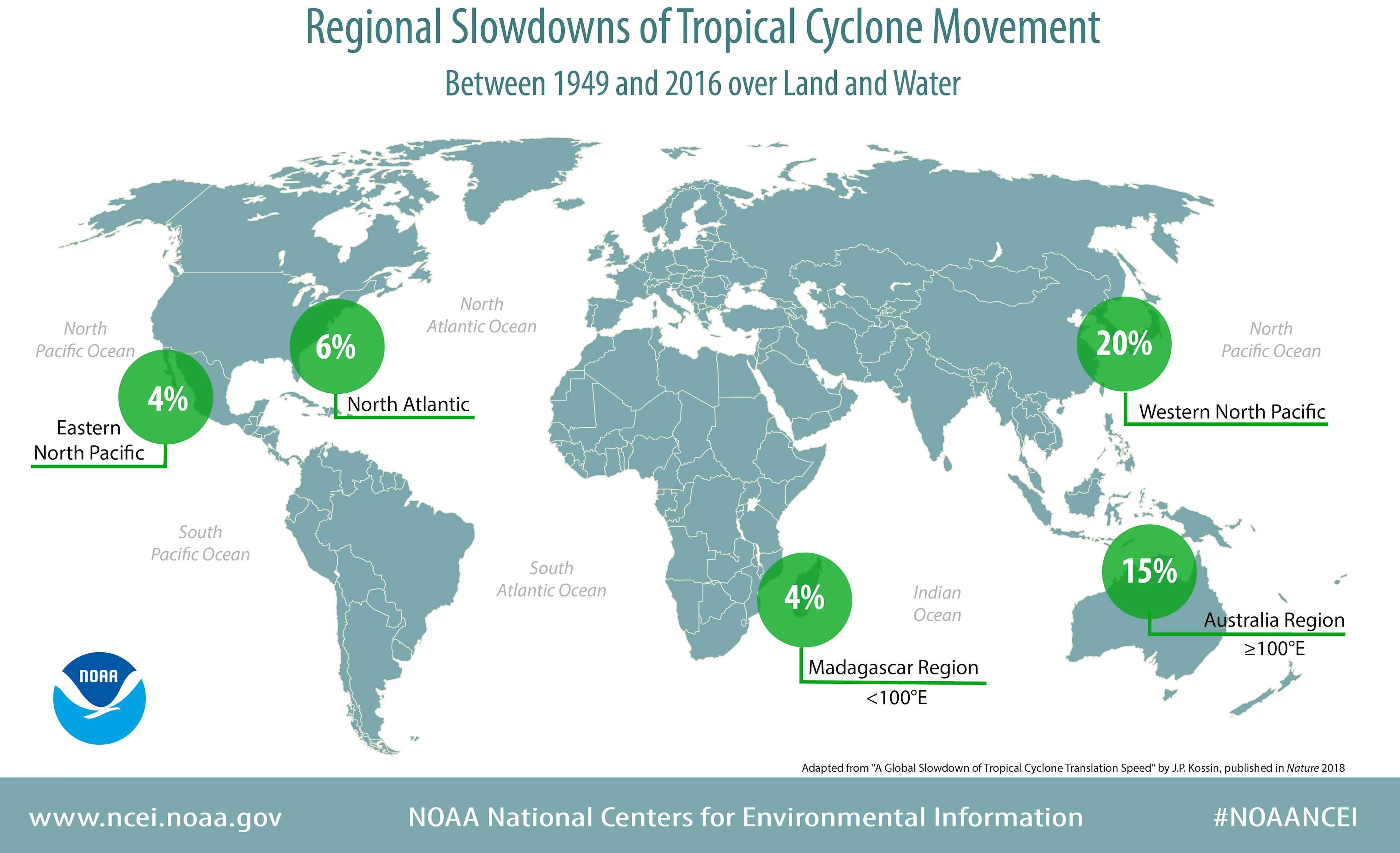
Regionally, the western North Pacific Ocean has seen the greatest slowing at 20 percent, followed by the region north of Australia.
(Source: NOAA)
Among the most relevant values are the slowdown of 21 per cent and 16 per cent found over land areas affected by western North Pacific and North Atlantic tropical cyclones, respectively. Also the slowdown of 22 per cent over land areas in the Australian region.
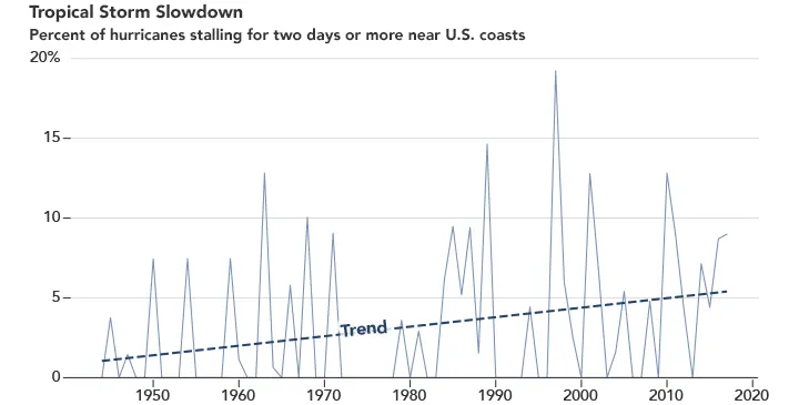
North Atlantic hurricanes have been stalling, as Dorian did, leading to more extreme rainfall events. Their average forward speed has also decreased by 17 per cent, from 18.4 km/h to 15.3 km/h, from the period of 1944 to 2017.
The U.S. Atlantic coast has also seen an increase in slower, longer-lasting hurricanes. During the base period of 1944 to 2017, nearly half of the 66 hurricanes that stalled for more than 2 days over a coastal region occurred in the last third of that period. Only 17 occurred in the first period.
Hurricane Dorian's slow, destructive track through the Bahamas fits a pattern scientists have been seeing over recent decades. One they expect to see continue as the planet warms; hurricanes stalling over coastal areas and bringing extreme rainfall.
WATCH BELOW: HARVEY TRAJECTORY AND RAINFALL BY NOAA
Another notorious case of a hurricane stalling is Harvey. The hurricane arrived and stalled over the Texas coast during August 2017. The unprecedented rainfall totals provide a notable example of the relationship between regional rainfall amounts and tropical cyclone translation speed. Any systematic past or future change in the translation speed of tropical cyclones, particularly over land, is therefore highly relevant when considering potential changes in local rainfall totals.
Scientists are still working to understand the ways that global warming affects hurricanes and tropical storms, including its influence on wind patterns. One thing they do know is the location where tropical cyclones reach maximum intensity has been shifting towards the poles. This may be related to or even causing the slowdown. They also know that warmer ocean waters intensify storms if all other conditions remain constant. In the case of Dorian, this would probably translate into an increased rainfall amount of at least 5 per cent over affected areas. With Harvey, the increase would jump by 14 per cent.
Source: NCEI/NOAA