North America just saw its coldest meteorological winter in years

Despite the frigid cold across Canada and the northern United States, on a global scale, this past winter was one of the warmest on record.
While many Canadians suffered through chilly weather in February, the month closed out one of the top five hottest meteorological winters for the globe.
In their latest Global Climate Report, NOAA scientists ranked February 2022 as the 7th warmest February since 1880. Meanwhile, both NASA and the Japanese Meteorological Agency (JMA) ranked the month as 5th warmest on record (tied with February 2015 according to NASA, and in a three-way tie with 2019 and 2015 by JMA records).
Although warmer than February 2021, overall, the global average temperature for the month was cooled by the La Niña pattern that currently persists in the equatorial Pacific Ocean, as well as a significant blob of Arctic cold across Canada, and cool spots across northern Africa, China, and Australia.
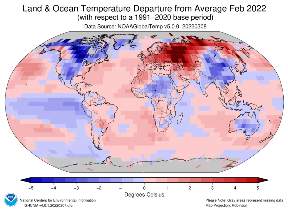
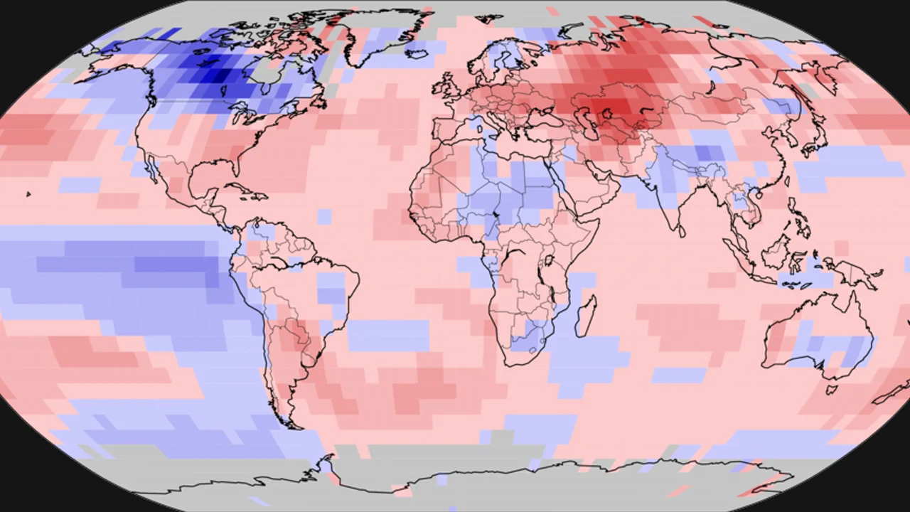
This global temperature anomaly map, for February 2022, reveals a significant contrast on opposite sides of the world, with frigid cold across Canada and unusually warm conditions across Russia. Credit: NOAA NCEI.
METEOROLOGICAL WINTER
With unusually cold temperatures affecting Canada and the United States over the past three months — even compared to typical winter conditions — NOAA says that February now closes out the coldest meteorological winter seen across North America since 2014.
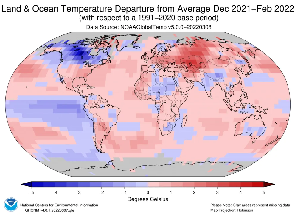
Compared with typical temperatures seen around the globe from December through February, Canada was the coldest place on Earth. Credit: NOAA NCEI
When looking at only January and February of 2022, it was "the coldest such period since 1996," NOAA wrote.
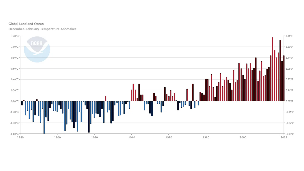
Despite this, on a global scale, the last three months ranked as the 5th warmest December to February period in the record books.
Compared to the full record of global average temperatures for December to February (meteorological winter in the northern hemisphere and meteorological summer in the southern hemisphere), the past three months were the 5th warmest overall. Credit: NOAA NCEI
ARCTIC SEA ICE
A few weeks ago, amid the southern summer, Antarctic sea ice reached its smallest extent ever seen, in decades of record keeping. As it reached this record low, on Feb. 25, at the other end of the planet, Arctic sea ice may have already reached its maximum extent for the year.
According to the National Snow and Ice Data Center (NSIDC), the largest extent for sea ice across the Arctic Ocean so far in 2022 was measured on Feb. 25, at 14.875 million square kilometres. This was the largest February extent seen since 2014, and the average February extent only ranked as the 14th lowest on record.
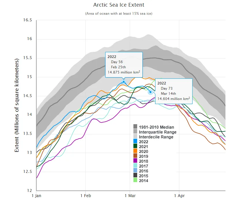
Arctic sea ice extent during February 2022 was trending above the past eight years. However, with the maximum extent so far this year recorded on Feb. 25, we may be looking at an extremely early start to the melt season. Credit: NSIDC/Scott Sutherland
As shown in the graph above, as of March 14, sea ice extent was already down by over 270,000 sq km since that maximum. It is not unheard-of to see the extent increase again in March. After all, sea ice extent is not only a product of cold temperatures, but also of how the winds spread the ice around. However, the likelihood of seeing another 'bump' in the extent values becomes more remote as we get into the latter half of the month.
If Feb. 25 was, indeed, this year's winter maximum, it would be one of the earliest winter peaks for Arctic sea ice on record.
When it comes to how things evolve in the months to come, records have shown that the greatest influence on sea ice extent throughout the spring and summer is the weather patterns that develop across the Arctic during that part of the year. Even the 2012 melt season, which produced the current record low summer minimum, began with a fairly large and late winter maximum. Still, starting the melt season up to a month earlier than usual is not the kind of head start we like to see. It may put us on track for a new record summer minimum come September.