This year still on track to be Earth's warmest in the record books

April 2020 was one of the warmest months of April since record keeping began over 140 years ago
Globally, 2020 is turning into one of the warmest years on record.
The National Oceanic and Atmospheric Administration (NOAA), the Japanese Meteorological Agency (JMA) and Europe's Copernicus Programme all agree that April 2020 is now the second warmest month of April seen since record-keeping began in the late 1800s. In all, only 2016 saw a January through April with warmer temperatures around the globe.
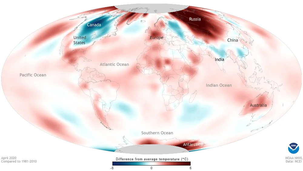
Global temperature anomalies for the month of April from 1880 to 2020. April 2020 now ranks 2nd warmest, behind April 2016, and is the 44th consecutive month of April with temperatures above the 20th century average. Credit: NOAA
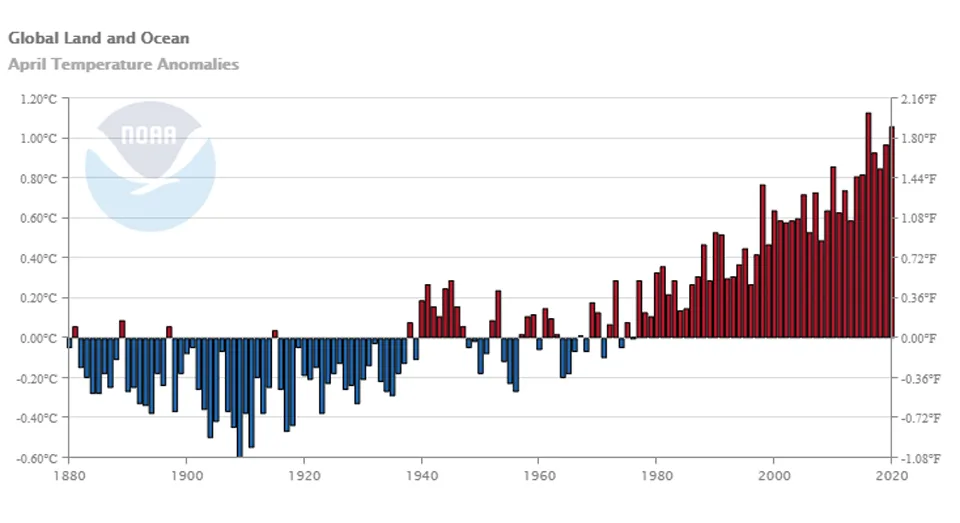
By NOAA's records, global temperatures were 1.06°C above the 20th century average in April 2020. That's only 0.07°C lower than April 2016 (+1.13°C), which still stands as the warmest April by their account.
From NOAA's latest Global Climate Report, the agency's scientists say that the eight warmest Aprils on record have occurred since 2010, and April 2016 and 2020 both exceeded the 20th century average by 1.0°C or more. So far, this April is the 424th consecutive month where the global average temperature was above the 20th century average.
According to NASA's records, though, temperatures around the world for April 2020 average out to 1.18°C above the 20th century average. That's 0.04°C higher than the average for April 2016 (+1.14°C), making April 2020 now the warmest month of April in their records since 1880.
This becomes even more apparent when these temperatures are plotted against the yearly seasonal cycle, as shown below.
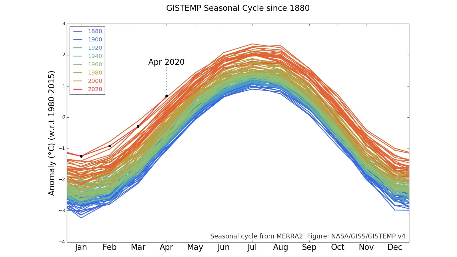
NASA's GISTEMP Seasonal Cycle plot shows April 2020 temperatures surpassing April 2016. Credit: NASA Goddard Institute for Space Studies
SCORCHING 2020
Even though the first 4 months of 2020 are still second to 2016 in most record books, this is still fairly alarming.
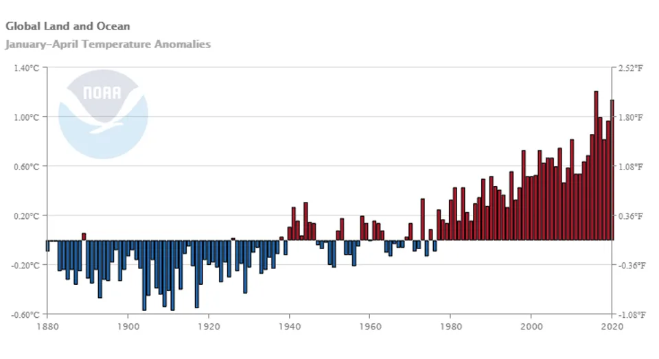
Global temperature anomalies for January through April from 1880 to 2020. January-April 2020 now ranks 2nd warmest, behind the same period in 2016. Credit: NOAA
The first four months of 2016 - currently the warmest year on record across all global climate databases - started off the year with temperatures far-surpassing even those in the previous warmest year on record, just one year before. This was of no surprise, as scientists had just watched the development of the strongest El Niño seen in modern history throughout 2015, and this climate pattern was in the process of dumping ocean heat into the atmosphere throughout the first half of 2016.
According to NASA climatologist Gavin Schmidt, 2015 and 2016 would have been record-setting years even without El Niño. By his calculations, the climate pattern added about +0.05°C to 2015's global temperatures and it accounted for an extra +0.12°C in 2016. So, while the contribution was noticable, El Niño wasn't responsible for global temperatures breaking records two years in a row.
By comparison, from the end of 2019 through 2020 so far, we experienced the weakest El Niño on record since 1980. While the record 2015-2016 pattern reached a 2.7 on NOAA's Oceanic Niño Index (ONI), the 2019-2020 pattern barely managed to get above the threshold for an El Niño, reaching only 0.6. For comparison, every other El Niño over the past 40 years has reached at least 0.7 on the ONI scale.

Temperature anomalies so far in 2020 (black) are rivaling the hottest year on record, 2016 (orange). Credit: NOAA
Based on the above graph, subtracting out the influence of El Niño would bring 2016's temperatures closer to those seen in 2017. On the other hand, with the impacts of this latest El Niño likely being negligible, 2020's temperatures would barely move from where they are.
From El Nino model forecasts, there is some indication that the rest of this year will either have neutral conditions - neither a warm El Niño pattern nor a cold La Niña - or perhaps a weak La Niña. Even so, if the typical trend of NOAA’s ‘year-to-date’ graph holds, it gives 2020 a very good chance of becoming the new warmest year on record.
Sources: NOAA | NASA | JMA | Copernicus | NOAA ONI