Canadian scientists help develop most accurate space-based snow tracking ever

Satellite measurements of the northern hemisphere snowpack just got a 21st century boost
An international team of scientists has produced the most accurate look at snow on the ground for the Northern Hemisphere to date. While their unique approach has revealed significant losses in northern Canada’s snowpack over the past 40 years, it is providing a much more complete picture of this polar region.
Canada's winters have been growing shorter as the climate changes. Studies have already shown that this is having an impact on snow extent - the amount of ground covered by snow at any time. Even more important, however, the amount of snow mass in North America is being dramatically affected by this trend.
A study published in the journal Nature has presented a new way to measure snow mass by combining data from satellites, ground measurements and computer modelling. This novel method greatly reduces the errors inherent in measuring snow from space, with the margin for error dropping from 33 per cent to just over 7 per cent.
"The method can be used to combine different observations and it provides more accurate information about the amount of snow than ever before," Jouni Pulliainen, the lead researcher of the study and Research Professor at the Finnish Meteorological Institute (FMI), said in a press release.
The research team's results reveal that, since 1980, snow mass has remained fairly steady for the entire Northern Hemisphere. In North America, however, snow mass has been declining at the rate of 46 billion tonnes per decade. That represents a loss of over 15 per cent in total yearly snow mass over the past forty years.
"Climate models, at least, all project that we'll see more snowfall in the future, because the atmosphere gets wetter as it gets warmer," says Dr. Chris Derksen, a research scientist with Environment and Climate Change Canada who was a co-author on this new study.
"In northern Canada, it appears any increase in snowfall is being offset by a shorter snow accumulation season. As it gets warmer in fall the accumulation season is starting later; as it gets warmer in spring the accumulation season ends earlier."
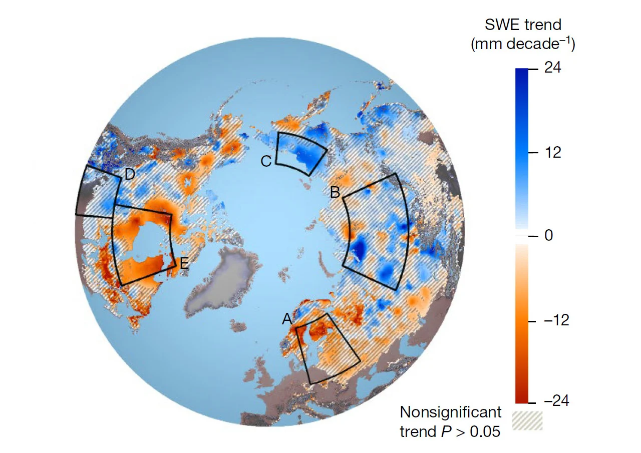
Tends in snow mass of the Northern Hemisphere show both North America and northern Europe with deep losses. Meanwhile snow trends appears to even out across Eurasia, with a substantial increase in northeastern Siberia. Credit: Pulliainen, et al./Nature
"The observed loss of snow mass is potentially impactful for many sectors," Derksen said, noting how it is influencing the large hydropower developments of Hydro-Quebec, and the potential for this to impact operations and ability to generate excess capacity to export to the United States.
"Spring snowmelt is an important source of freshwater to regenerate surface water (e.g. in wetlands) and groundwater used for agriculture and human consumption," he added. "Dry snow years are also associated with heightened wildfire risk in the following summer."
Over the period covered by the study, it was the snow mass measured across northern Europe and Siberia that largely offset the losses recorded in North America. While snow accumulations across Eurasia were fairly steady over the past four decades, it was much more variable in northern Canada and the United States.
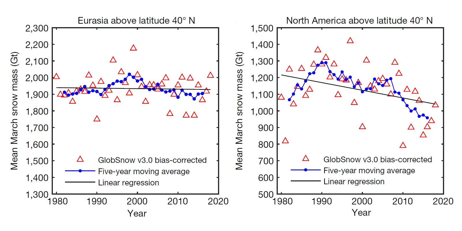
Snow mass trends for Eurasia and North America for the month of March, from 1980-2018, which is when the snowpack is at its peak. Triangles represent yearly values, the black line is the long-term trend for the entire 39-year period, and the blue points represent the short-term trends. Credit: Pulliainen, et al./Nature
Looking at the short-term trends, the new corrected snow mass measurements produced by the study showed a dramatic increase across northern Canada and the United States through the 1980s. This is likely due to the expected rise in snowfall amounts due to having a warmer, wetter atmosphere. Since 1990, however, that trend has reversed - slowly to start, but accelerating rapidly in the last 10 years of the study period. While roughly one quarter of the North American snowpack was lost from 1990-2018, most of that loss took place in the last decade.
SNOW EXTENT VS SNOW MASS
Snow extent is the amount of ground surface area that is covered by snow at any time. The effects of a large snow extent versus a small snow extent are important, due to snow's bright surface reflecting sunlight back into space. This directly affects the energy balance of Earth. Having a record of snow extent is very useful for weather and climate modelling, and it is fairly easy for satellites to capture this information, as it can be assessed from just normal visible-light imagery.
Snow mass, on the other hand, is the total amount of snow on the ground, measured in billions of tonnes (gigatonnes). This gives a more complete view of how much snow there actually is on the ground, since it takes the depth of the snow into account. So, it provides a look at exactly how much water is stored in the snowpack, and its potential impact on the water cycle when the spring melt arrives.
"You can have a very thin snow cover and a very deep snow cover, and its energy-budget impact is the same," Derksen said. "But its water-cycle impacts would be completely different."
Public utilities and water resource managers depend on this kind of information. At the moment, measuring snow mass is more difficult than measuring snow extent, though. According to Derksen, while there are satellites that measure Earth's water from space, there are no satellites currently in orbit that are dedicated to measuring snow mass. Instead, scientists have learned to use existing satellite observations to their advantage.
"We've never had a satellite mission that is designed and optimized specifically for snow mass," Derksen said. "So, we're taking advantage of other instruments that provide a useful measurement, but perhaps not the perfect measurement."
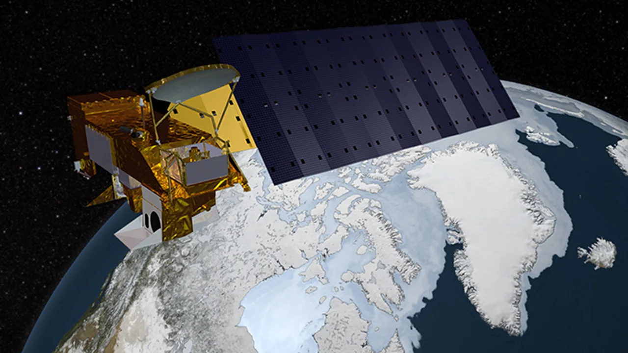
The Advanced Microwave Scanning Radiometer-Earth Observing System (AMSR-E) sensor, on board the polar-orbiting Aqua satellite, collects passive background radiation from Earth, which scientists can use to measure snow mass on the ground. Credit: NASA
One down-side of this is the resolution of the data collected. Since the satellites are gathering very weak amounts of radiation naturally emitted by Earth, each 'pixel' of a snow mass map needs to represent a large area, of 25 square kilometres. As a result, there has been a large margin for error in these measurements, which has reduced their usefulness. Also, given the large variations in elevation, terrain and snow cover that can be contained in a 25 square kilometre area in the mountains, collecting meaningful data from alpine regions of the world has been next to impossible.
Until new methods or missions can be developed, the results of this study represent the current 'state of the art' for snow mass assessment.
FURTHER IMPROVEMENTS
Even with surface measurements supporting satellite observations in this study, there are ways of improving the assessment of snow mass even further.
One way, according to Derksen, is to make better use of the data that is already being gathered. This study is another step in that process.
The other is to put a dedicated satellite into space that can actively and directly measure snow mass. To this end, Environment and Climate Change Canada and the Canadian Space Agency are working, in partnership with Canadian industry, to develop a new satellite radar mission specifically designed for this purpose.
"I think this is a really important area where Canada can make a unique contribution," Derksen said.
"We need satellite data, some surface observations, and snow models," he added. "It's a three-legged stool - remove one leg and it falls over!"
Top Photo Credit: The GOES-16 geostationary weather satellite captured this view of snow extent over North America on January 4, 2018. Credit: NOAA