A climate threat lurks in rivers around the world. New research shows where
Rivers and streams offer far more than pretty scenery or an opportunity for a summertime cool-off. They make up an important component of a global system that determines how much carbon is stored in soil or sent into the atmosphere.
New research shows that human activities are directly disrupting this system and increasing the amount of carbon sent into the atmosphere.
SEE ALSO: Answer to high ocean acidity may lie in carbon transfer from wetlands
When tree litter falls into a waterway, it becomes fuel for an entire ecosystem. Microorganisms feast on the detritus, fish consume it or it falls into the river bed where the carbon becomes trapped.
But human activity can speed up the decomposition of leaves and other litter, sending more carbon dioxide up into the atmosphere. One key element is a warmer climate, which makes microbes more active. Chemicals from fertilizer, like phosphorus and nitrogen, also nourish microbes and lead to faster litter decomposition.
Accurately modelling these changing dynamics is key to fighting climate change, so a team of researchers led by Scott Tiegs at Oakland University in Michigan organized a global initiative to take stock.
Over 150 scientists in 40 countries, including Canada, were sent standardized cotton strips — instead of tree leaves, which are typically used — to measure the rate of organic decomposition at local sites.
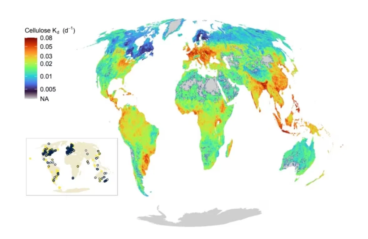
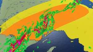
A global map showing the estimated rates of decomposition for organic matter in waterways. Red indicates faster decomposition. (Tiegs, Capps, et. al. 2024)
Now, researchers have combined these field samples with globe-spanning data sets to create a machine learning algorithm that estimates rates of decomposition around the world.
"What was shocking about our data was that even though we were selecting these relatively minimally impacted sites, we could still see hot spots where humans have really had an impact, either through urbanization, or agriculture or a combination," said Krista Capps, an aquatic ecosystem ecologist at the University of Georgia who co-authored the work.
The resulting global map illustrates the damaging effects of human activity: parts of the central United States, Southern Canada and Europe — areas of high population density, urban development and agriculture — are bright red hotspots for faster decomposition, "strongly suggesting continental-scale human impacts on carbon cycling in rivers," according to the study.
The research was published on Thursday in Science.
A 'double whammy' for Canada
How quickly leaves decompose in waterways might seem like a niche concern, but it has major significance for the climate.
(Trevor Brine/CBC)
"The implication is we can't count on water bodies, including the rivers, streams and lakes, to continue to hold on to carbon like we have," said Paul Frost, a professor of aquatic science at Trent University in Peterborough, Ont., who participated in the field study. "We may be switching them from carbon sinks to carbon sources."
Frost emphasized that researchers have studied decomposition and its links to the climate in the past, but he said that "it was a big step forward for them to be able to standardize" field testing with cotton strips.
Researchers from all over Canada participated, he said, measuring how the strips decomposed in local waterways over the course of four weeks and mailing them in for analysis. Variables like water temperature and the biome were also recorded.
Feeding this data into a predictive algorithm fills crucial gaps in knowledge, especially in areas such as the tropics, and remote or difficult-to-access areas where data collection can be challenging.
The global map generated using the algorithm produced results with relevance that hits closer to home as well. For example, Frost said, the map shows a clear gradient from north to south in Canada, with decomposition rates slowing down with colder temperatures. This disparity is also tied to the types of trees that thrive in these environments.
WATCH: How 'stratospheric dehydration' could help offset carbon emissions
As part of the work done to model the decomposition rates of natural litter compared to the cotton strip, the researchers found that pine litter decomposes more slowly than oak litter. As the climate warms, oak-heavy deciduous forests may spread further north, which would mean a higher potential for faster decomposition rates and more carbon being released into the atmosphere.
"In southern Ontario, there's a pretty clean demarcation where we go from deciduous forests into boreal coniferous forests, and that line is going to creep farther north," said Frost. "So that's going to be a double whammy in terms of rates of decomposition."
Brian Branfireun, an environmental scientist at Western University who was not part of the study, said that the work shows Canada's North is at elevated risk as temperatures rise.
"The places to watch out for are the parts of the world like the Canadian boreal forest that are currently lower on the scale for decomposition as shown in this study — northern latitudes are warming much faster than southern, so these are the places where changes in the future will be most significant," he said in an email.
From prediction to prevention
The researchers have shared their models online for anybody to use, which they wrote "will enable scientists and natural-resource managers to forecast changes in the functioning of river networks at a planetary scale."
"Climate change is an emergency unlike any that humanity has ever faced — we simply don't have time to go everywhere in the world and make these important measurements over the next 20 years," said Branfireun.
"These approaches let us use the data that we have and when combined with our best scientific understanding, we make estimates about environmental processes in places that we have never visited, let alone made a measurement."

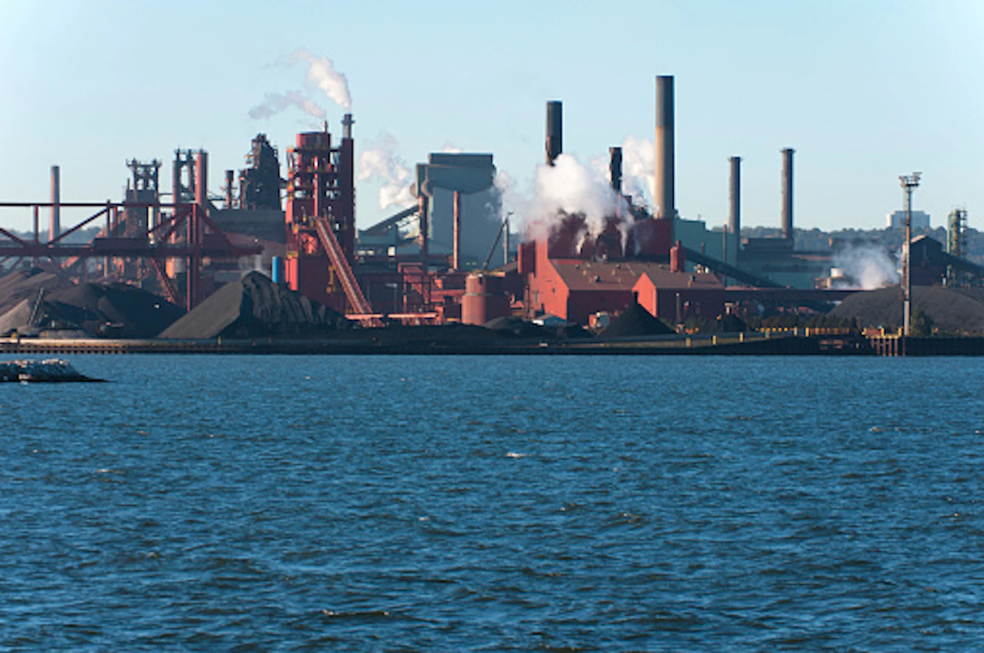
Hamilton, Ont. (Getty Images/SimplyCreativePhotography/183355334-170667a)
The algorithm is also just a first step that can be further improved with even more on-the-ground research, according to the researchers.
"With more data, it's going to just continue to improve," said Capps.
"The next step is to start looking at these impacted streams, and see if these patterns are even more emphasized, or if we can find other, more nuanced factors that are driving these relationships."
In the meantime, the clear indication that human factors such as added nutrients from agriculture or urbanization are having an impact is information that can be used to aid efforts to mitigate the damage, said Frost.
"We really do need to be more careful with nutrients in the environment," he said.
"Anything we can do to more carefully use and manage nutrients in agricultural and urban landscapes would help slow down decomposition and help these systems be better carbon storage sites."
Thumbnail courtesy of Getty Images/SimplyCreativePhotography/183355334-170667a.
The story was originally written by Jordan Pearson and published for CBC News.