How a mammoth hurricane rapidly intensifies in mere hours

Some of the strongest hurricanes in history grew their ferocious winds in only a couple of hours
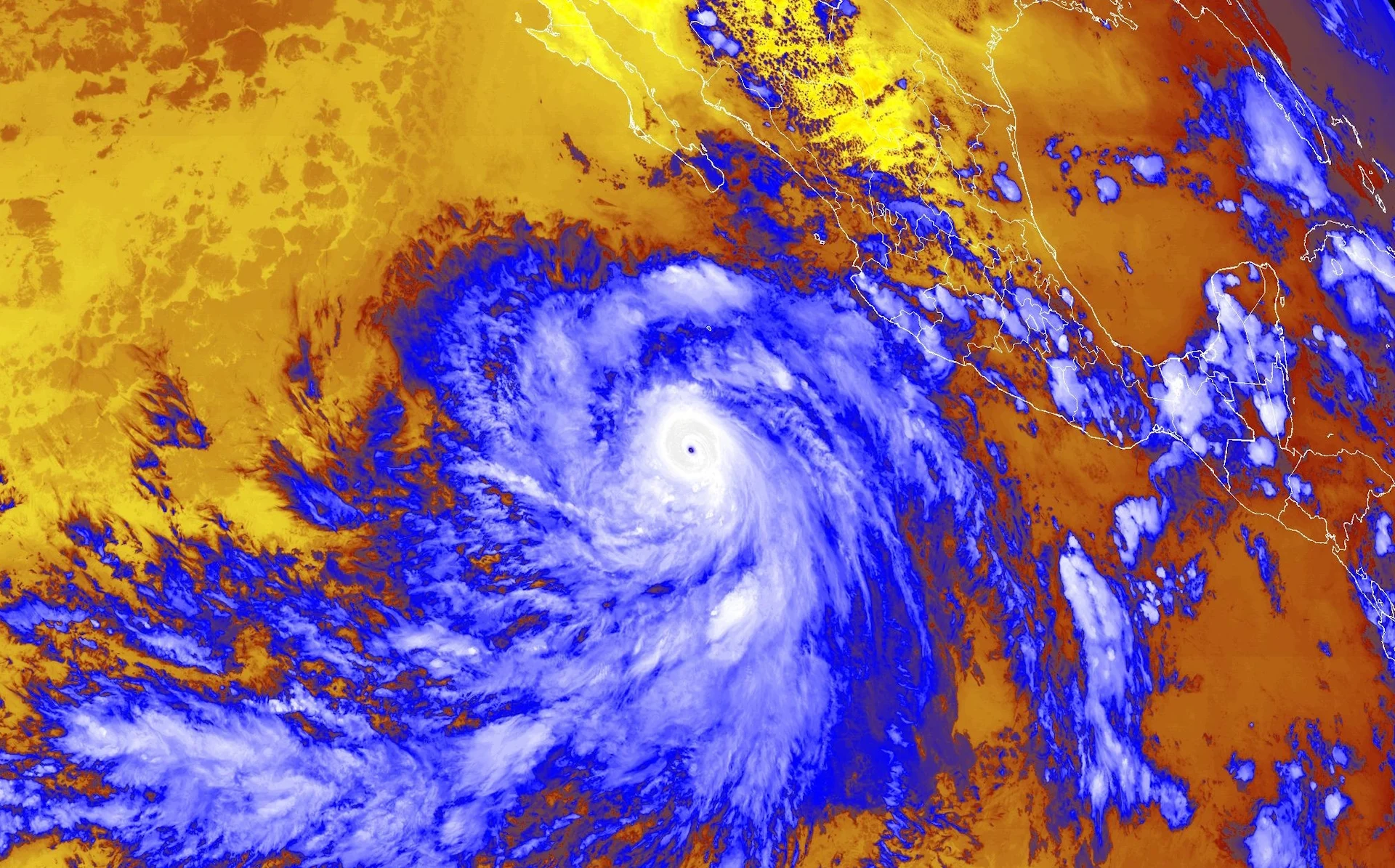
Hurricane Patricia grew into one of the most intense storms ever recorded as it swirled into western Mexico, and it achieved this feat in just 24 short hours.
Coastal residents woke up on October 22, 2015, to find Hurricane Patricia a few hundred kilometres offshore as a budding Category 1 with maximum winds of 165 km/h. Just 12 hours later, Patricia had exploded into a scale-topping Category 5 with maximum winds of 275 km/h.
But it wasn’t done yet.
DON’T MISS: How hot water fuels the world’s most powerful hurricanes
Hurricane Hunters flying through the storm the following morning found that it had grown even stronger to pack maximum sustained winds of 340 km/h, making it the strongest hurricane ever recorded near North America, more than doubling its maximum winds in just 24 hours.
Rapid intensification is a remarkable process that can make a storm far stronger than anyone anticipated.
Patricia is one of dozens of storms that took advantage of favourable conditions to rapidly intensify at horrifying speed—many of them as they closed in on landfall.
Hurricanes are fragile, frightening engines
Even the strongest hurricane begins its life as a tiny cluster of thunderstorms. These thunderstorms pull warm, humid air up from the surface in order to grow and thrive.
If there’s low wind shear, ample moisture, and toasty sea surface temperatures, a scrappy bunch of thunderstorms can persist for hours and even days at a time.
STAY SAFE: What you need in your hurricane preparedness kit
Hurricane Lee as a Category 4 storm on September 7, 2023. (NOAA)
Updrafts feeding energy into these thunderstorms pull massive amounts of unstable air up and away from the surface, leaving behind a void of less air—and lower air pressure—in their wake.
Winds swirling around the newly formed low-pressure centre help organize the thunderstorms into a dense core, working in unison to inhale vast amounts of unstable air from the surface.
This process acts like an efficient feedback cycle by lowering the air pressure at the centre of the tropical cyclone. A lower air pressure creates stronger winds that maintain those thunderstorms, allowing the entire system to grow and intensify.
As long as conditions remain favourable, this process can continue until that modest tropical depression grows into a major hurricane.
WATCH: Hurricanes are growing more intense, and climate change is probably to blame
Rapid intensification created some of history’s worst storms
Ingredients are rarely perfect for a tropical system to develop. That’s why most of the systems we see in an average season are only short-lived tropical depressions or tropical storms.
Even when conditions are favourable, the evolution from tropical depression to tropical storm, then tropical storm to hurricane, and finally hurricane to major hurricane, typically takes up to a week as the storm struggles to put itself together.
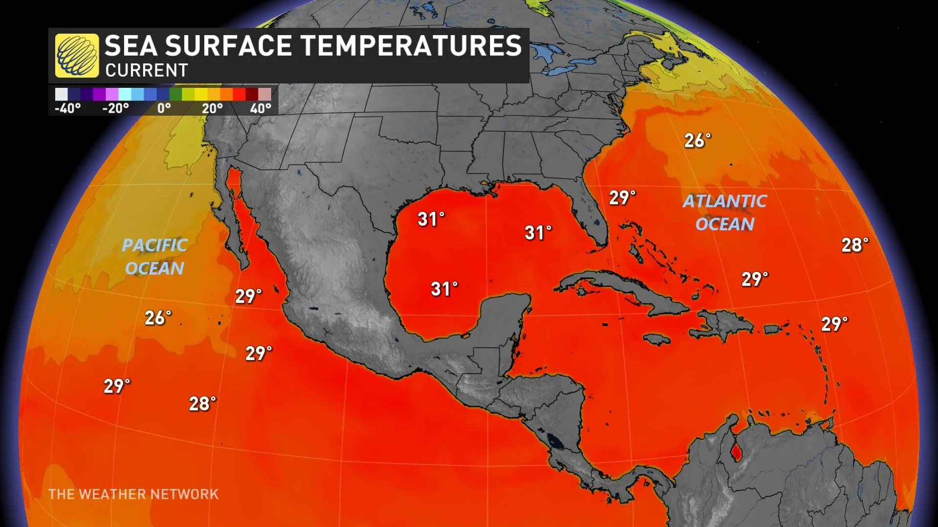
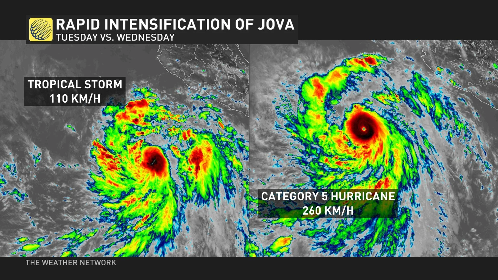
Sea surface temperatures near 30°C supported the rapid intensification of Hurricane Jova in the eastern Pacific and Hurricane Lee in the Atlantic within days of one another in September 2023.
But every once in a while, we’ll see all the ingredients line up perfectly to allow a tropical cyclone to rapidly intensify in a matter of hours instead of days.
The U.S. National Hurricane Center (NHC) puts the threshold for rapid intensification when a storm’s maximum winds jump about 55 km/h in 24 hours. It’s rare for a system to get its act together so quickly that its winds strengthen that much in a single day.
When rapid intensification happens, though, look out.
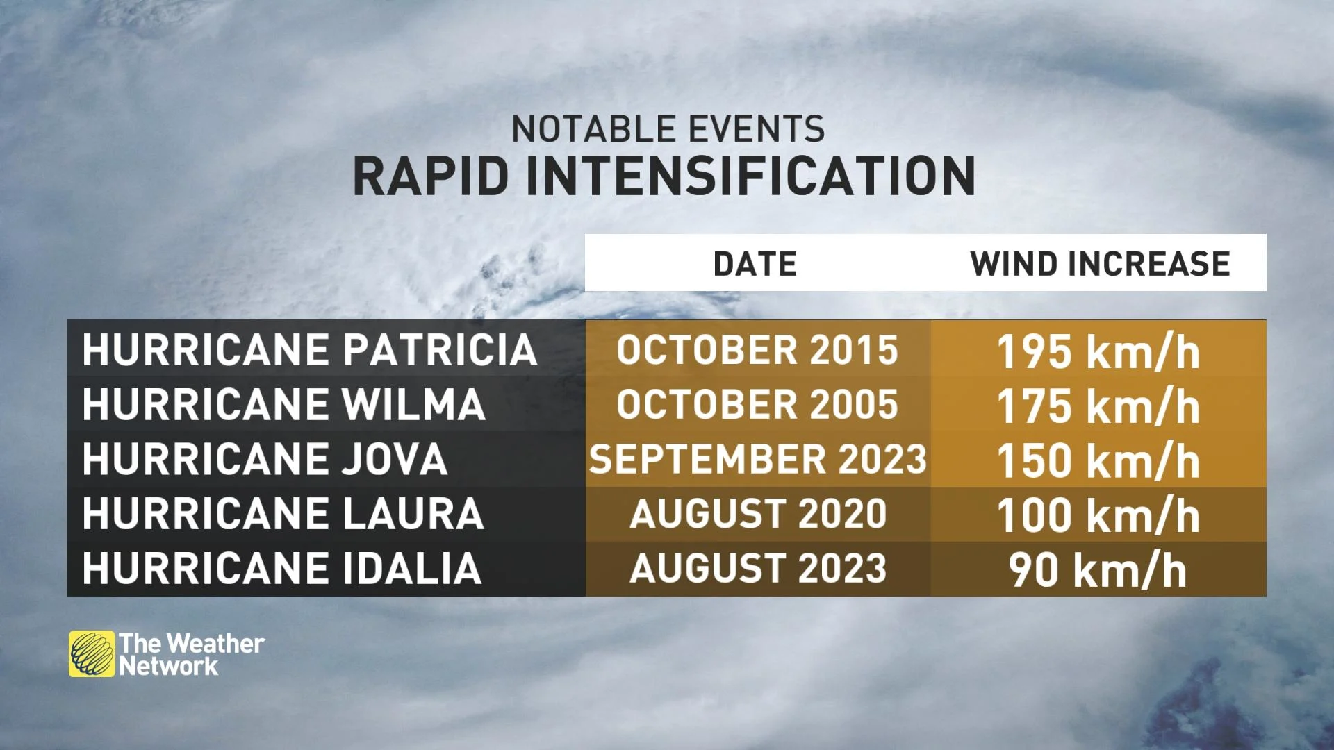
Hurricane Patricia’s rapid intensification of 195 km/h was the all-time record for a tropical system in the eastern Pacific or Atlantic basin during the modern era, according to the NHC’s analysis of the storm’s history.
Plenty of other hurricanes have intensified at mind-boggling speeds. Hurricane Wilma grew into the most intense hurricane ever recorded in terms of air pressure when it rapidly intensified in the western Caribbean in October 2005.
Wilma’s winds jumped 175 km/h in just 24 hours, achieving Category 5 strength with maximum winds of about 300 km/h and a minimum central pressure of 882 mb on the ocean surface—about 130 mb lower than you’d expect to see on a ‘normal’ and calm day.
RELATED: The curse of storm nine: Why so many “I” hurricanes are monsters
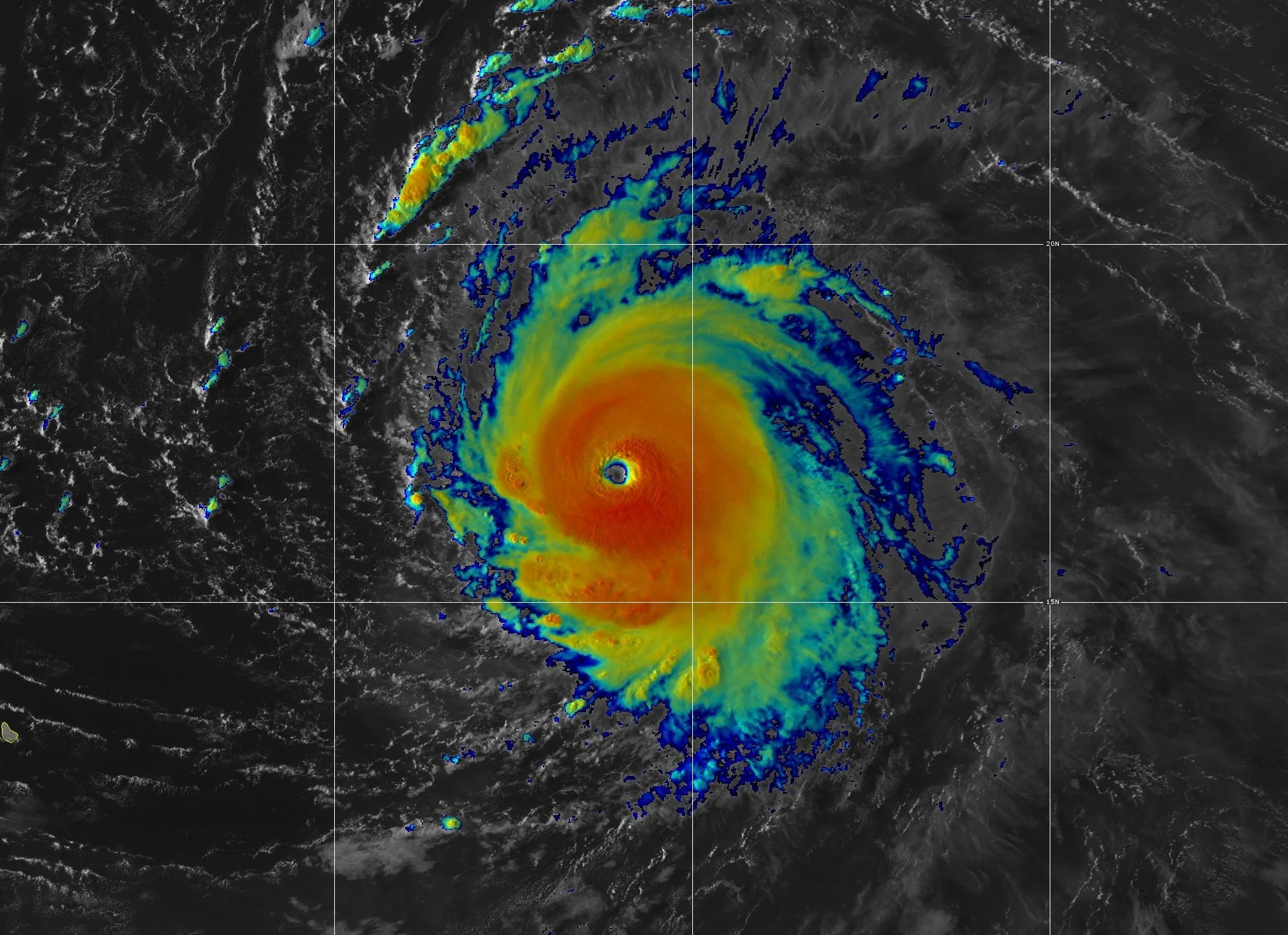
Hurricane Jova grew from a tropical storm to a scale-topping Category 5 in just 24 hours in September 2023, taking advantage of waters warmed by El Niño to strengthen its winds by about 150 km/h in one day.
Many of the notable hurricanes that have made landfall in the United States in the past decade—including Harvey, Michael, Laura, Ida, Ian, and Idalia—all rapidly intensified into major hurricanes as they approached landfall along the Gulf Coast.
Rapid intensification is rare—but could happen more often
Rapid intensification is remarkable because it’s rare. For all of their potential fury, tropical systems are incredibly fragile structures. One tiny flaw can send them unraveling until they fall apart.
Destructive wind shear, intrusions of dry air, or pockets of cold water can all disrupt the thunderstorms around the storm and force it to weaken. Even minor ‘hiccups’ within the storm’s internal structure can cause it to stumble and lose its organization.
Lightning around Hurricane Ian's eye in August 2022. (CIRA/CSU & NOAA)
The strongest hurricane ever recorded in the Atlantic Ocean was Hurricane Allen, which peaked at 305 km/h back in August 1980. A few hurricanes have come close, including 2005’s Wilma, but it’s exceptionally rare for a storm to achieve its full potential because of all the little things that can go wrong throughout its lifetime.
Hurricanes have an upper limit to how much they can strengthen based on factors like water temperatures. Even if everything works perfectly, it can only maintain that incredible strength for a little while before its structure begins to break down.
SEE ALSO: What the science says about hurricanes and climate change
Climate change’s influence on our atmosphere could allow for more frequent rapid intensification events in the future.
“Some of the most recent research into hurricanes has shown that the intensity of these storms is increasing, and climate change is the likely culprit,” says The Weather Network’s Scott Sutherland in an article exploring research into the trend.
Warmer sea surface temperatures could allow for more opportunities for rapid intensification events. 2023’s Hurricane Idalia’s growth from a tropical storm to a major hurricane as it approached Florida was in large part due to record-warm ocean temperatures in the eastern Gulf of Mexico.
Header image of Hurricane Jova on September 6, 2023, courtesy of NOAA.