'Potential disaster in the making,' forecasters eye major threat in the Gulf

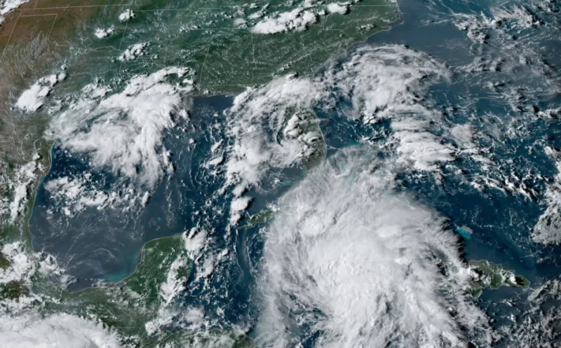
The ninth named storm of this Atlantic hurricane season formed just west of Jamaica on Thursday afternoon. Tropical Storm Ida will head toward Cuba on Friday before entering the Gulf of Mexico and strengthening into a hurricane. The storm could pose a major threat to the northern Gulf Coast. Ida isn’t the only system we’re watching. More on the active tropics, below.
TROPICAL STORM IDA FORMS IN THE CARIBBEAN SEA
Ida took advantage of a favourable environment to quickly grow into a tropical storm on Thursday evening as it spun about 160 km west of Jamaica.
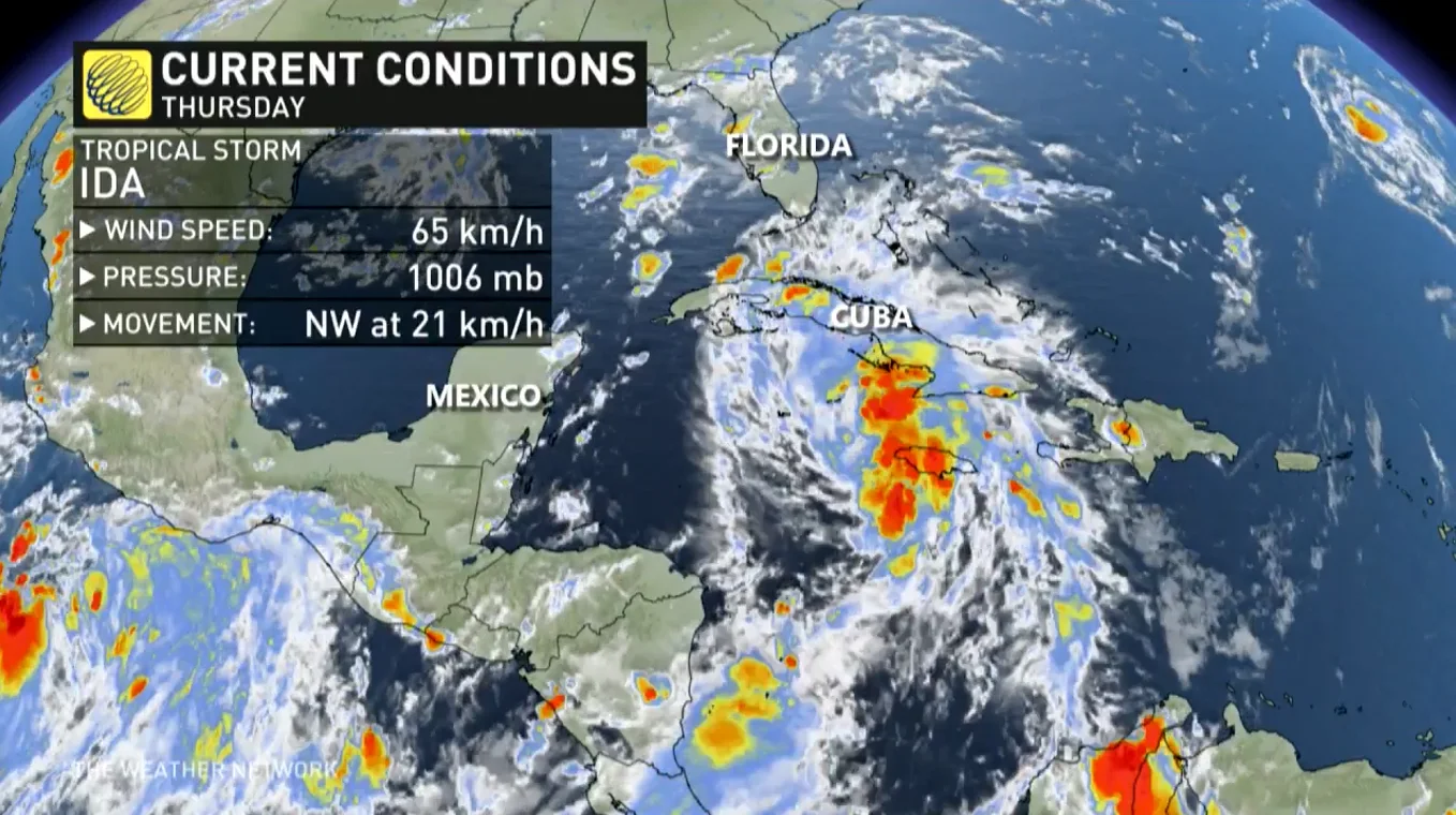
The U.S. National Hurricane Center’s Thursday evening update found Tropical Storm Ida with maximum sustained winds of 65 km/h, with higher gusts.
Forecasters expect Ida to steadily strengthen over the next couple of days as it heads northwest through the Caribbean, making landfall in far western Cuba on Friday afternoon.
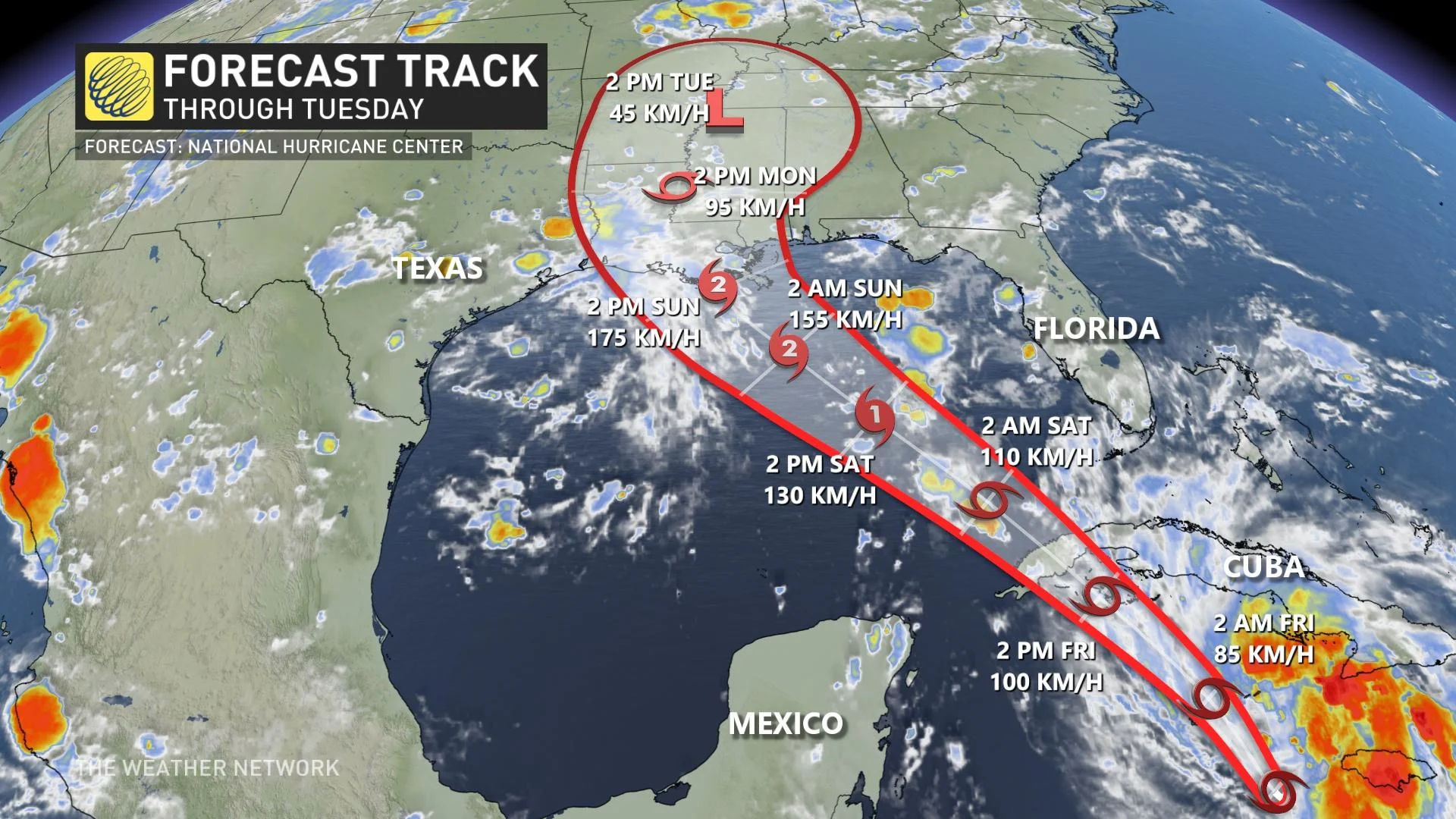
From there, the storm will likely intensify into a hurricane as it carves a path over very warm waters in the Gulf of Mexico. The NHC warns that the storm could be close to a major hurricane by the time it approaches land.
The system will likely make landfall on the northern Gulf Coast during the day on Sunday. While it’s too soon to say precisely where the storm’s eye will come ashore, the storm's strong winds, storm surge, flooding rains, and tornadoes will have a wide reach that affects communities far away from the point of landfall.
SEVERAL FACTORS COULD MAKE IDA EXTREMELY DANGEROUS
"This is a potential disaster in the making for the Gulf of Mexico," says Tyler Hamilton, a meteorologist at The Weather Network. "This is a worst-case scenario to get an intensifying hurricane as it approaches the Gulf states," Hamilton added.
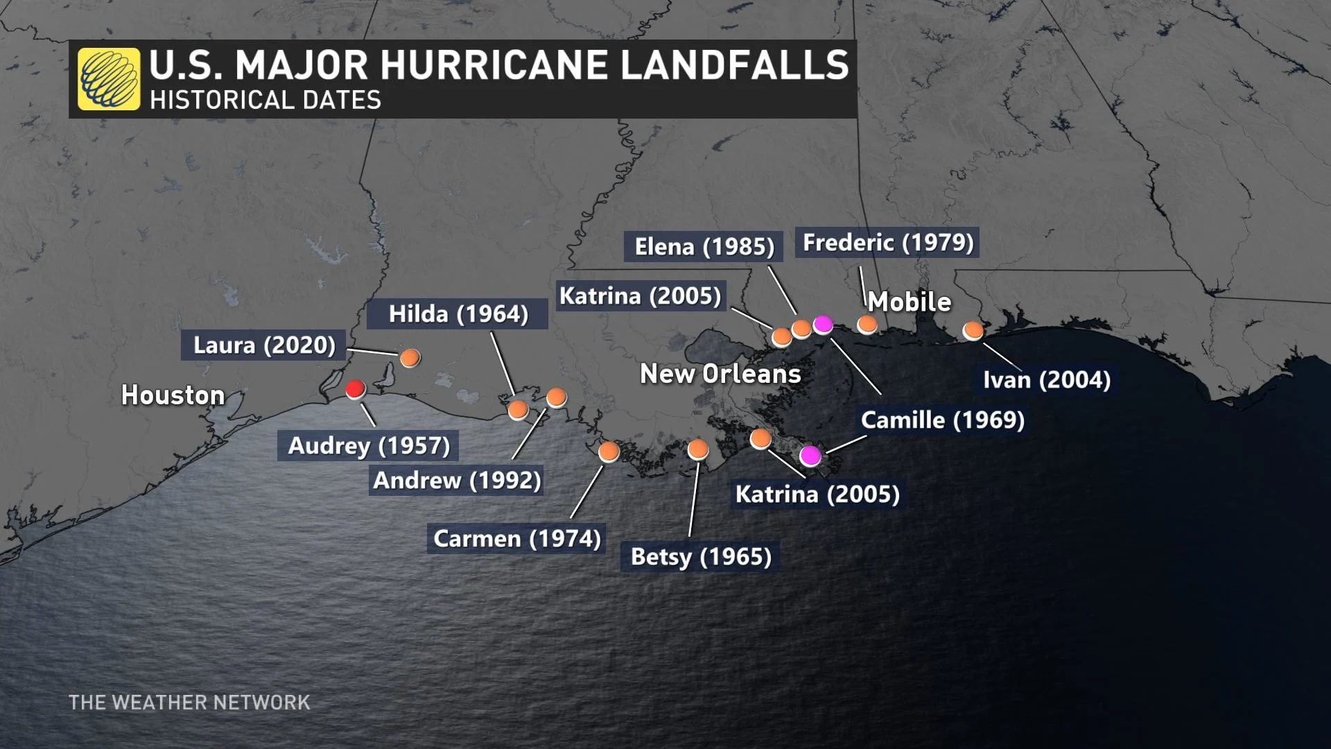
The northern Gulf Coast is a vulnerable spot for a strong hurricane to make landfall. The region has a long history of major hurricane landfalls, including Camille in 1969 and Katrina in 2005.
One of the greatest threats from any storm to hit this region is storm surge.
Storm surge is seawater pushed inland by a tropical system’s strong and persistent winds. This kind of flooding is a significant threat to life and property whenever a hurricane makes landfall.
The terrain of the Gulf Coast makes this region extremely susceptible to storm surge.
For example, much of Louisiana’s coastline consists of flat swamps, marshes, and beaches. This terrain offers little resistance to a storm surge, allowing seawater to push many kilometres inland from the coast.
The predicted path of the storm is particularly concerning for New Orleans, Louisiana. The majority of neighbourhoods there reside at or below sea level, leaving the city prone to flooding from both storm surge and heavy rainfall.
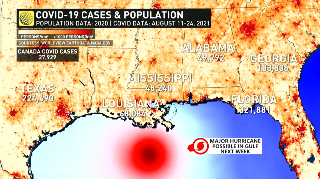
Making matters worse, the southern United States is in the midst of a sharp spike in coronavirus cases. Hundreds of thousands of new cases have been reported across the region in the past few weeks.
Many hospitals across the southern states are overwhelmed by the influx of coronavirus patients. The New York Times reported last week that there were no intensive care beds left in the entire state of Alabama on August 18, a reflection of the dire situation in this part of the U.S. This storm and its potential aftermath could further stretch medical workers and resources to their limits.
WE’RE WATCHING TWO OTHER DISTURBANCES IN THE ATLANTIC
Ida isn’t the only system in the Atlantic Ocean right now. There are two other disturbances out in the open waters that each have a high chance of development, according to the NHC’s tropical weather outlook on Thursday evening.
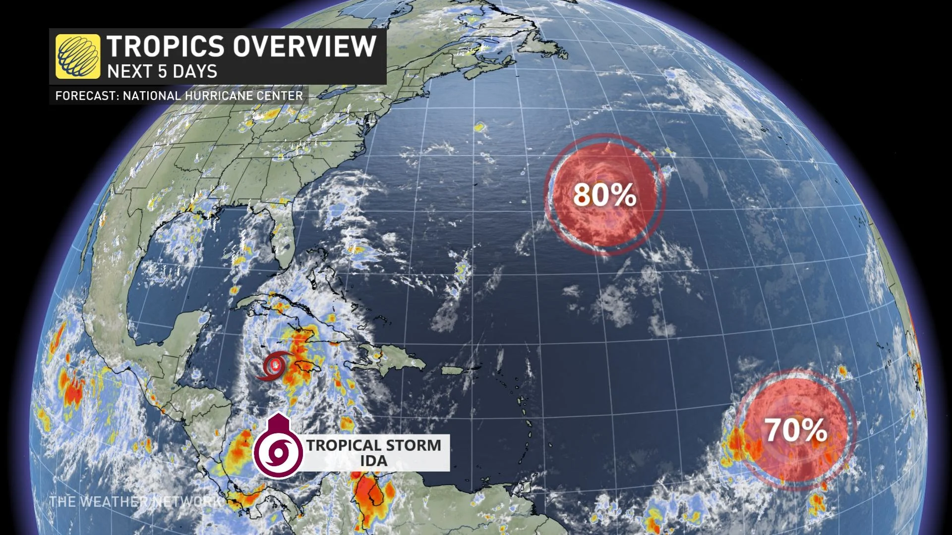
A disturbance about 1,000 km east of Bermuda has a high chance of developing into a tropical depression this weekend as it heads northeast into open waters.
Another disturbance, located about halfway between the Cabo Verde Islands and the Leeward Islands, also has a high chance of organizing into a tropical depression this weekend as it wanders in open waters out in the central Atlantic Ocean.
Neither of the two disturbances out in the Atlantic will affect land within the next couple of days.
After Ida, the next names on this year’s list for the Atlantic basin are Julian and Kate.
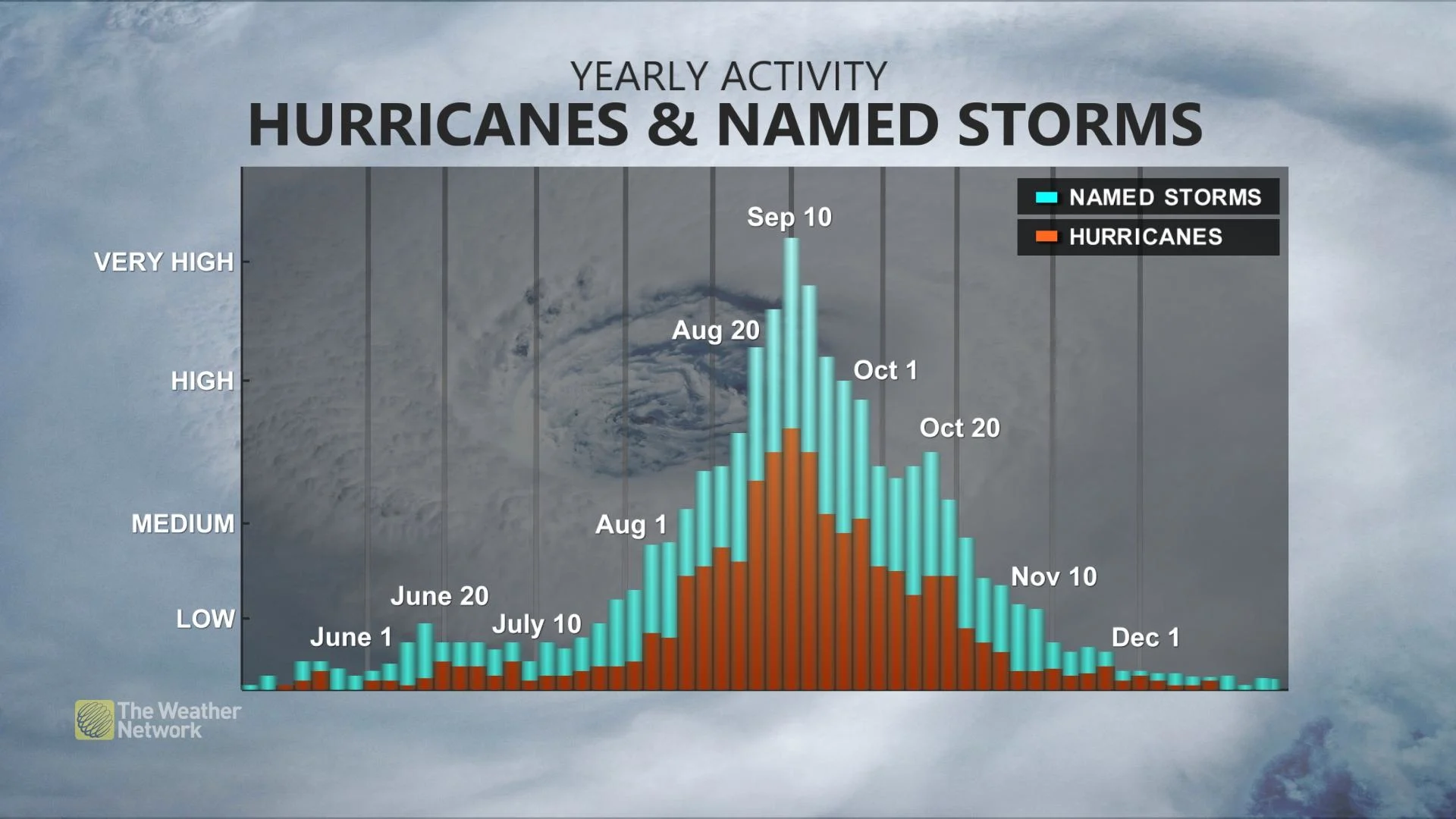
We’re quickly approaching the climatological peak of the Atlantic hurricane season. The season officially runs from June 1 through November 30, with a peak in activity during the second week of September.
Stay tuned to The Weather Network for the latest on the tropics.