Welcome to winter, Canada! A look at the season ahead

Ready to experience the thrill and adventure of the season? Grab your parka and find out what the season has in store for your region!
Winter is off to a slow and inconsistent start across Canada. Above seasonal temperatures have dominated all across the country so far during the month of December. The first few weeks of December however, are rarely a good indication of what it is to come for the rest of winter and we believe that is the case this year, especially for western Canada.
Visit our Complete Guide to Winter 2021 for tips on how to plan for the season ahead
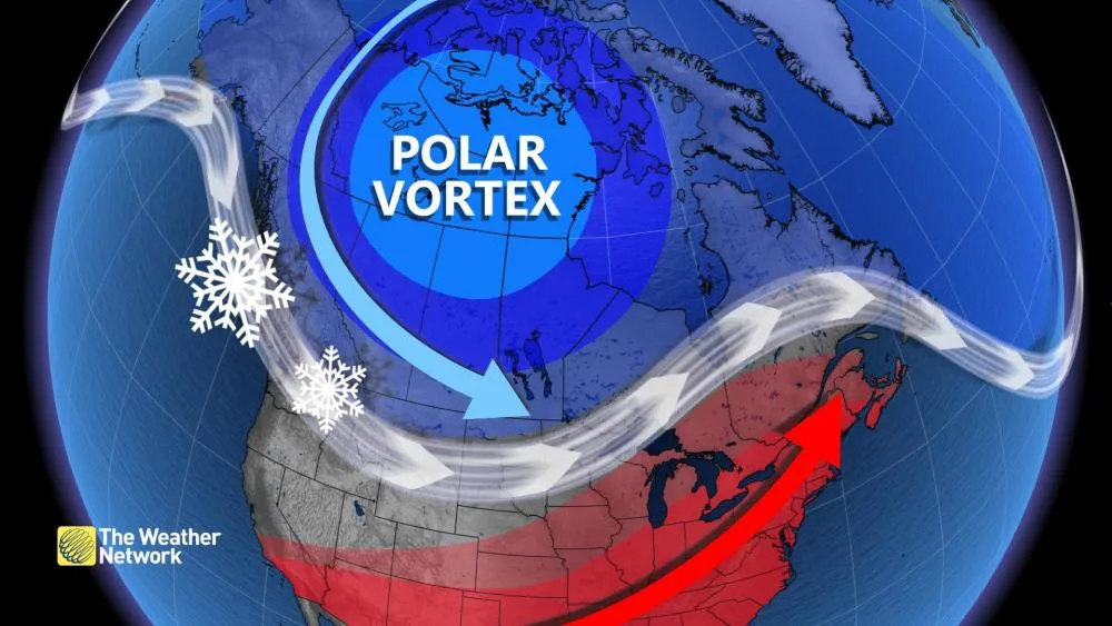
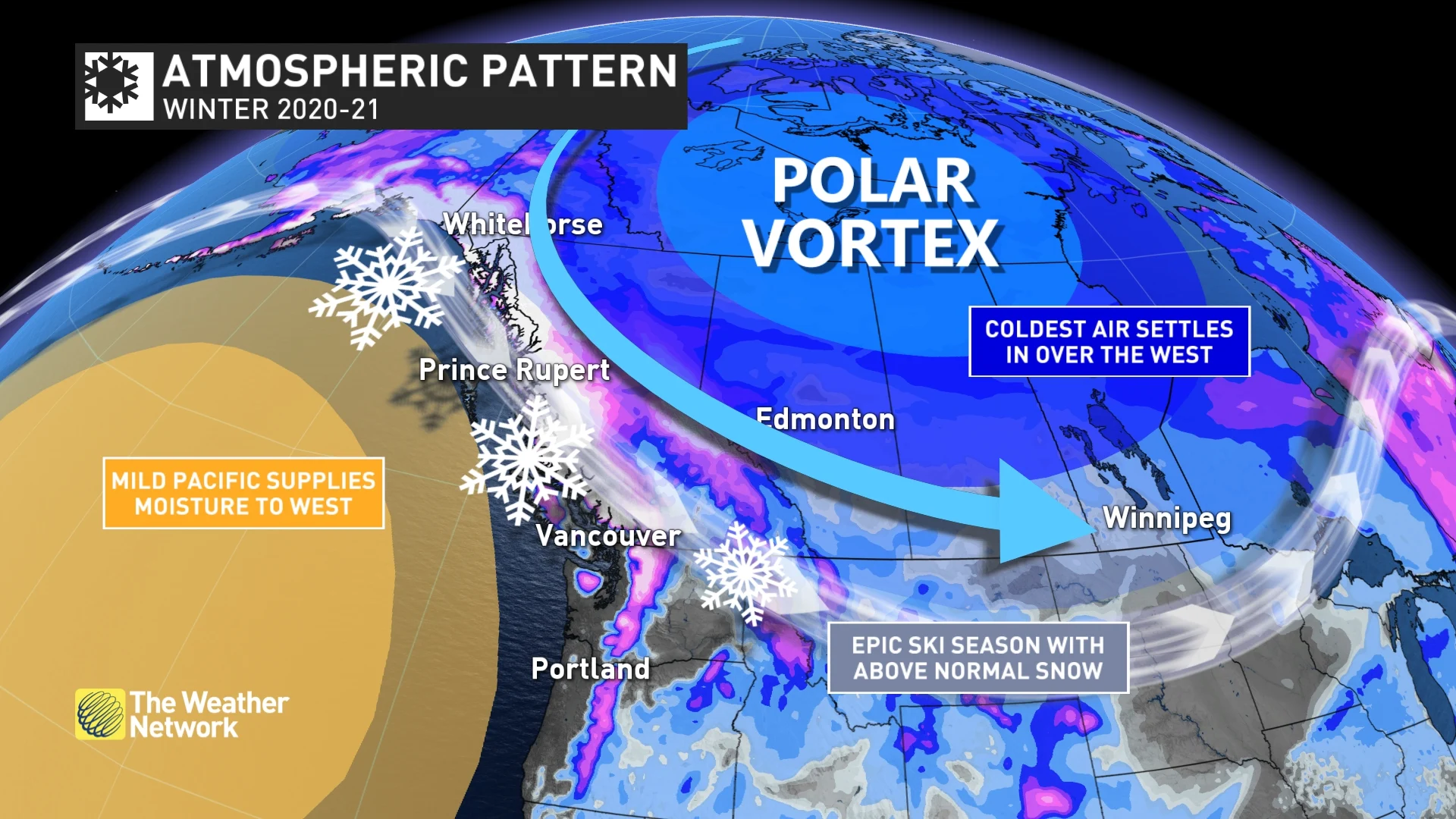
A wide variety of extreme weather is expected across Canada during the upcoming winter season. This should make for a memorable winter for much of the country. The focus of the severe cold will be across western Canada, especially during the second half of January, throughout February and into March. Meanwhile, extended periods of very mild weather are expected from the Great Lakes to the Maritimes with the potential for episodes of record-warmth. However, Arctic air will also push into these regions from time to time.
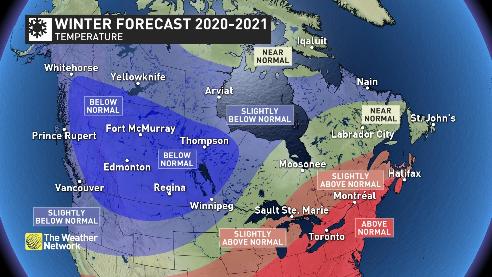
Before this pattern sets up though, we will see a changeable pattern across Canada. This pattern will be much more wintry than what we saw during the first half of December, but we will see back and forth swings in the temperature pattern across the country. We expect that we will finally lock into the dominant winter pattern once we get well into January and then that will persist through February and into March.
AN ACTIVE PATTERN DOMINATES WINTER
An active storm track is expected from coast-to-coast, and that will deliver an abundance of snow, ice, and even rain to most of Canada. The most active storm tracks are expected to be into southwestern Canada, and from the Great Lakes to the Maritimes.
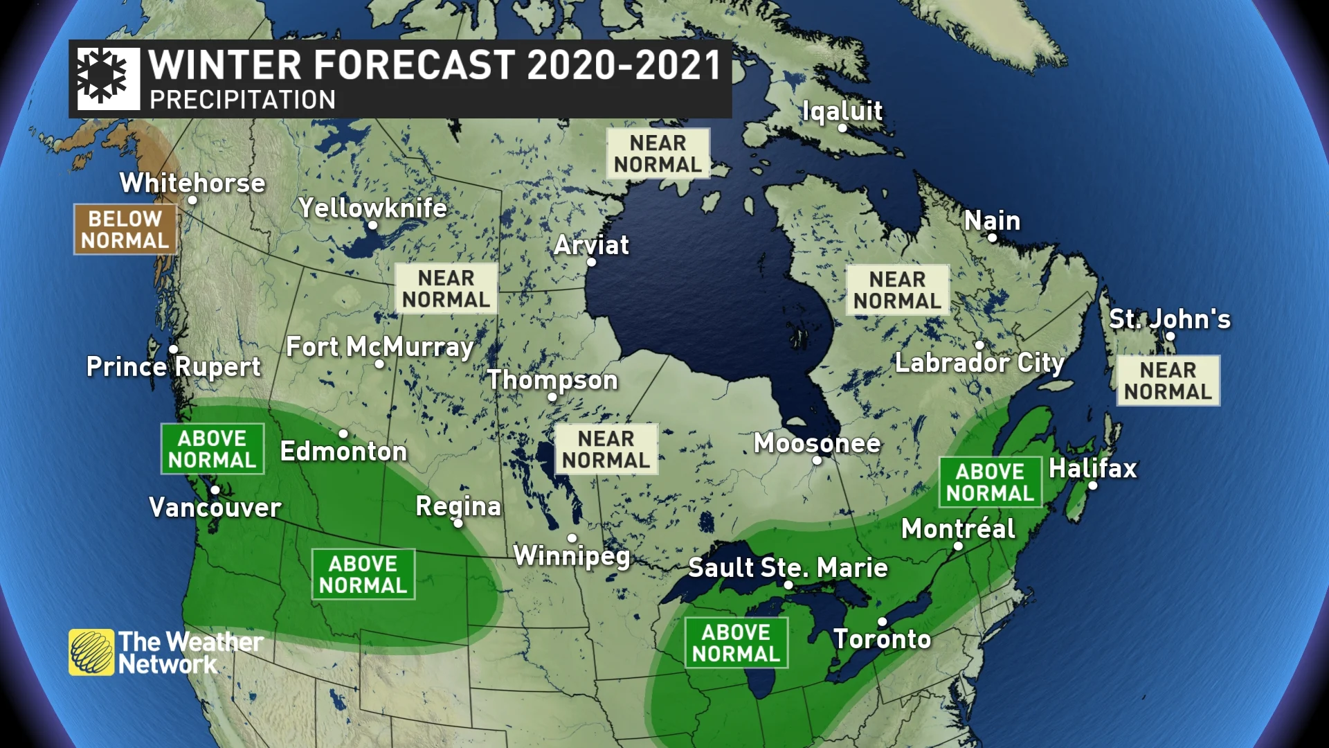
The combination of above normal precipitation and colder than normal temperatures across southern British Columbia, southern Alberta, and into southwestern Saskatchewan means that this region should also see above normal snowfall.
However, the snowfall forecast is much more tricky and uncertain across eastern Canada. In fact, the most uncertain part of this winter forecast is the amount of snow that we will see from southern Ontario to the southern Maritimes, where mild temperatures will dominate and many storms will bring a threat for ice and rain.
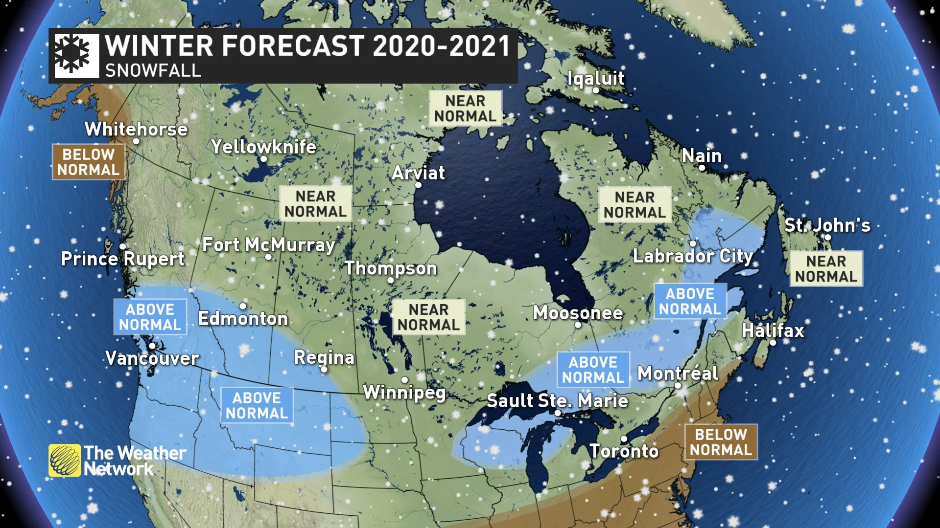
However, a mild pattern certainly does not mean that we won’t see an abundance of snow at times, especially across northern areas where temperatures can be well above seasonal and still cold enough for snow. This past November in southern Ontario was a great example of that, as this region recorded one of its warmest Novembers on record, and yet some places, including Toronto, received nearly triple its average snowfall for the month.
As we look back in history at winters that had a similar global pattern to this year (known as analogue years), we can readily see the potential for this winter to be feast or famine for those who enjoy outdoor winter sports from southern Ontario to the Maritimes. The snow totals from the analogue years range from well below normal snowfall to historic snowfall totals — depending on whether the storms repeatedly hit or just missed the region.
During the winter, we expect that the region from the Great Lakes to the Maritimes will see extended periods with little to no snow. However, we also have a heightened potential for major winter storms. The exact track of these storms will be the key to whether specific places in this region end up with above normal or below normal snowfall.
Below is a more detailed breakdown of what you can expect in each region of the country.
BRITISH COLUMBIA
A cold and stormy winter is expected to dominate across the province. While the pattern will be changeable through early January, we expect that a more consistently cold pattern will develop for the second half of January and this cold pattern should continue through February and into March. This will also bring a heightened risk for extended periods of frigid weather and heavy snow across the province, including the Lower Mainland and Vancouver Island. An outstanding ski season is anticipated with an abundance of fresh powder to enjoy, though heavy snow at times will make travel difficult through the mountains and to the ski areas.
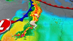
WATCH BELOW: AN ACTIVE STORM TRACK EXPECTED ACROSS B.C.
ALBERTA
A bitterly cold winter is expected across Alberta with above normal snowfall across the southern half of the province. However, the pattern will continue to be changeable through early January. We expect that a more consistently cold pattern will develop for the second half of January and this frigid pattern should continue to dominate through February and into March, with a heightened risk for extended periods of severe cold and dangerous wind chills.
SASKATCHEWAN AND MANITOBA
A frigid winter is expected across Saskatchewan and Manitoba with above normal snowfall across the southwestern parts of Saskatchewan and near normal snowfall elsewhere. However, a more changeable pattern will continue into early January. A more consistently cold pattern is expected during the second half of January and that should continue through February and into March with a heightened risk for extended periods of severe cold and dangerous wind chills.
WATCH BELOW: LA NIÑA COULD BE THE UNOFFICIAL SPONSOR FOR THE PRAIRIES THIS WINTER
NORTHERN ONTARIO
Northern Ontario will be the transition zone between areas that will see a frigid winter to the west and areas that will see mild winter to the south and east. As a result, northern Ontario should see more changeable temperatures throughout the season, which should tip to the cold side of normal across western areas, while eastern areas should tip to the mild side of normal. Near normal snowfall is expected for much of the region. However, an active storm track into the Great Lakes region should bring above normal snowfall to areas near and east of Lake Superior.
SOUTHERN ONTARIO
A rather mild winter is expected across southern Ontario. However, this does not mean that we will not see high-impact winter weather. Arctic air to our northwest will press into the region at times, but we do not expect extended periods of severe cold.
The first half of January appears to be when this region has the highest potential for a period of more consistent cold weather. We then expect that the second half of January and February will bring extended thaws with very mild temperatures and the potential for record warmth at times. However, the frigid air to the west will still attempt to press into the region from time to time, and an active storm track across the region will bring a heightened risk for major winter storms with heavy snow, ice, and rain.
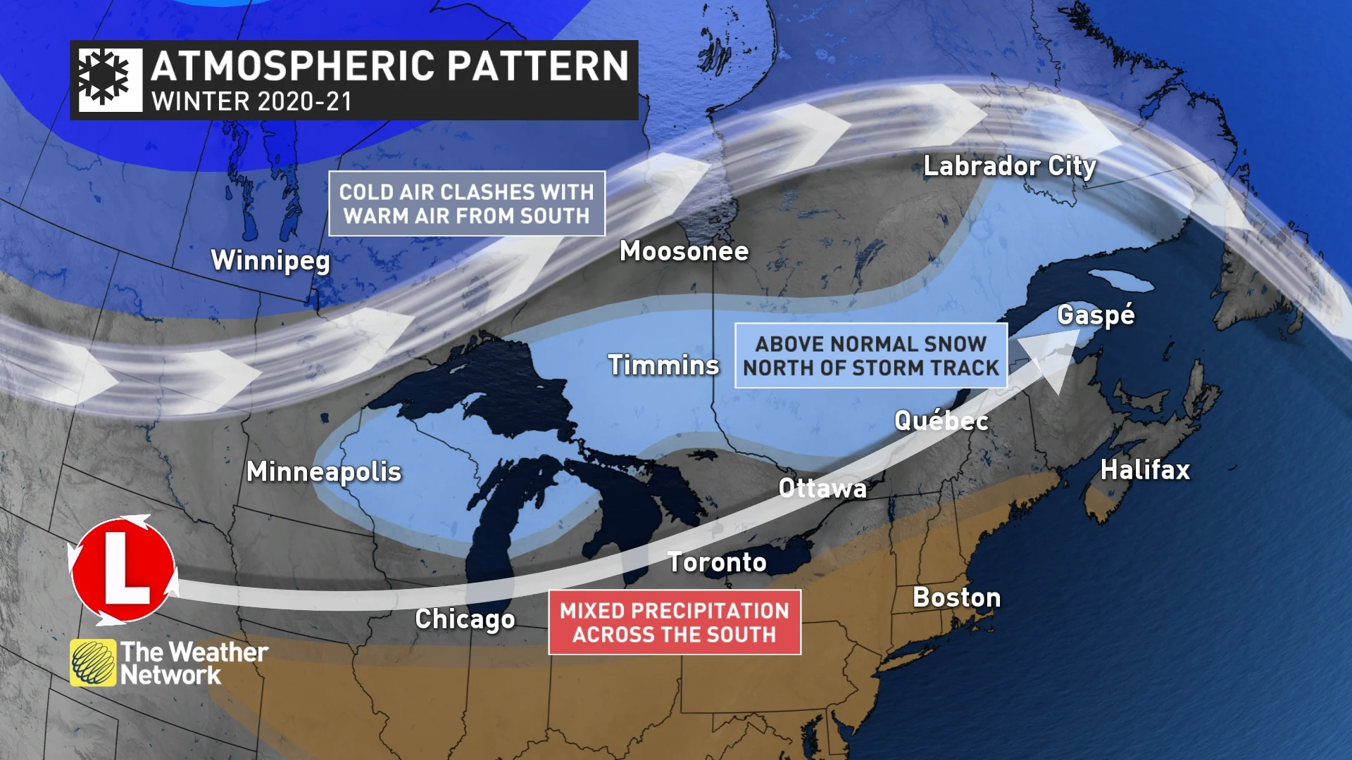
A lack of persistent severe cold this winter should mean below normal ice coverage on the Great Lakes. The lack of arctic air should also mean fewer days with lake-effect snow for the snow belt areas. However, the limited ice coverage on the Great Lakes also means that any time arctic air does show up, we will have the potential to see heavy snow squalls all the way through the end of the season.
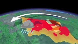
WATCH BELOW: ONTARIO'S STILL AT RISK FOR MAJOR STORMS, ACCORDING TO ANALOGUE YEARS
SOUTHERN QUEBEC
A mild winter is expected across the region, but this certainly does not mean that we will not see high-impact winter weather.
A changeable pattern is expected to continue into early January, and the first half of January looks to be when we have the best chance for a more extended period of cold weather. The second half of January and February will bring extended periods of very mild weather with the potential for record warmth at times. However, the frigid air to the west will attempt to press into the region from time to time, leading to an active storm track that could bring a heightened risk for major winter storms with heavy snow, ice, and even rain.
It is also important to keep in mind that during the heart of winter, "normal" temperatures are well below freezing, so it can be several degrees above normal and still be cold enough for snow.
WATCH BELOW: AN IN-DEPTH LOOK AT QUEBEC'S CHANGEABLE WEATHER PATTERNS
NEW BRUNSWICK, PRINCE EDWARD ISLAND & NOVA SCOTIA
A mild winter is expected across the Maritime provinces with periods of very mild weather and the potential for record warmth at times. However, that certainly does not mean that we will escape the season without periods of high impact winter weather. While we do not expect extended periods of severe cold, arctic air will still spread into the region at times.
This winter will also bring a rather active pattern with a wide variety of storm tracks and types (but fewer than normal nor’easters). A higher than normal percentage of the storms this winter will bring ice and rain rather than just snow to the region. So, while we expect above normal precipitation totals, snowfall should be near normal for most of the region.
NEWFOUNDLAND & LABRADOR
A typical winter is expected across Newfoundland and Labrador. Of course, this means an abundance of snowfall across the region. Fewer than normal nor’easters are expected, but an active storm track with a variety of storm types will impact the region. Some of these storms will bring very mild air to the province at times with ice and rain. However, periods of colder than normal weather should balance out these periods of mild weather. The back and forth swings in temperature that should come close to offsetting each other, resulting in near normal temperatures for the winter as a whole.
WATCH BELOW: ABOVE NORMAL PRECIPITATION IN THE FORM OF RAIN WILL BE POSSIBLE ACROSS PARTS OF ATLANTIC CANADA
NORTHERN CANADA
This winter is expected to be colder than most of the recent winters during the past decade. A colder than normal winter is expected for much of the Yukon, Northwest Territories and southern Nunavut with near normal temperatures for the high Arctic, with near normal snowfall for much of the region.