Chilly pattern brings stormy, snowy weekend to B.C.
The final weekend of spring will bring chilly, snowy conditions to parts of the West Coast as an active storm track blankets the region
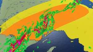
A cool and dreary weekend is on tap across British Columbia as an active storm track drapes across the West Coast.
Chilly temperatures and a risk for thunderstorms will pop up throughout southern B.C. to start the weekend, tapering to a potential for showers by Sunday.
Even though we’re rapidly closing in on the summer solstice this week, temperatures will fall far enough that accumulating snow will brush higher elevations across the province.
DON'T MISS: Hudson Bay’s iconic polar bears at risk of extinction in coming years: study
Showers, high-elevation snow to end the weekend
An upper-level low swinging over the West Coast will send temperatures plunging below seasonal for the middle of June.
Conditions will feel downright cold at higher elevations as this pattern sweeps over the province. Forecasters expect falling freezing levels to change rain over to snow throughout southern B.C.

Watch for snow throughout some of the province’s highway passes, including the Coquihalla, the Okanagan Connector, Allison Pass, Kootenay Pass, and Rogers Pass.
While this continuing pattern of cool and gloomy conditions may be unwelcome news for folks with outdoor plans across the province, additional precipitation and lower temperatures are beneficial as we head through wildfire season. Every little bit helps.
Header image courtesy of Michelle in Creston, B.C.
Stay with The Weather Network for the latest on your forecast across British Columbia.