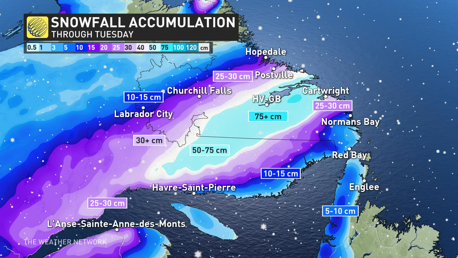
65 cm and counting: Dangerous blizzard in Labrador as winds ramp up

While Labrador faces the threat of record-setting snowfall amid dangerous blizzard conditions, Newfoundland will see blustery winds and heavy rainfall as a potent storm delivers its last and most significant wallop on Eastern Canada Tuesday.
More than 50 cm of snow had already been reported in central parts of Labrador by early Tuesday morning, with heavy snow expected to continue through the day bumping totals to nearly 80 cm in some places. Blizzard warnings remain in effect as winds strengthen and create near zero visibility and treacherous travel conditions. "Travel is not recommended," warns Envrionment Canada, adding that road closures are likely to expand as the day wears on. The system will also bring strong winds to Newfoundland, with gusts possibly as high as 100 km/h in coastal areas, as well as heavy rain. More on the timing and impact of this paralyzing storm set-up, below.
WEATHER HIGHLIGHTS:
Snow has intensified in Labrador, record breaking amounts expected by the end of the day
Blizzard conditions, with blustery winds and near zero visibility in snow through central Labrador Tuesday
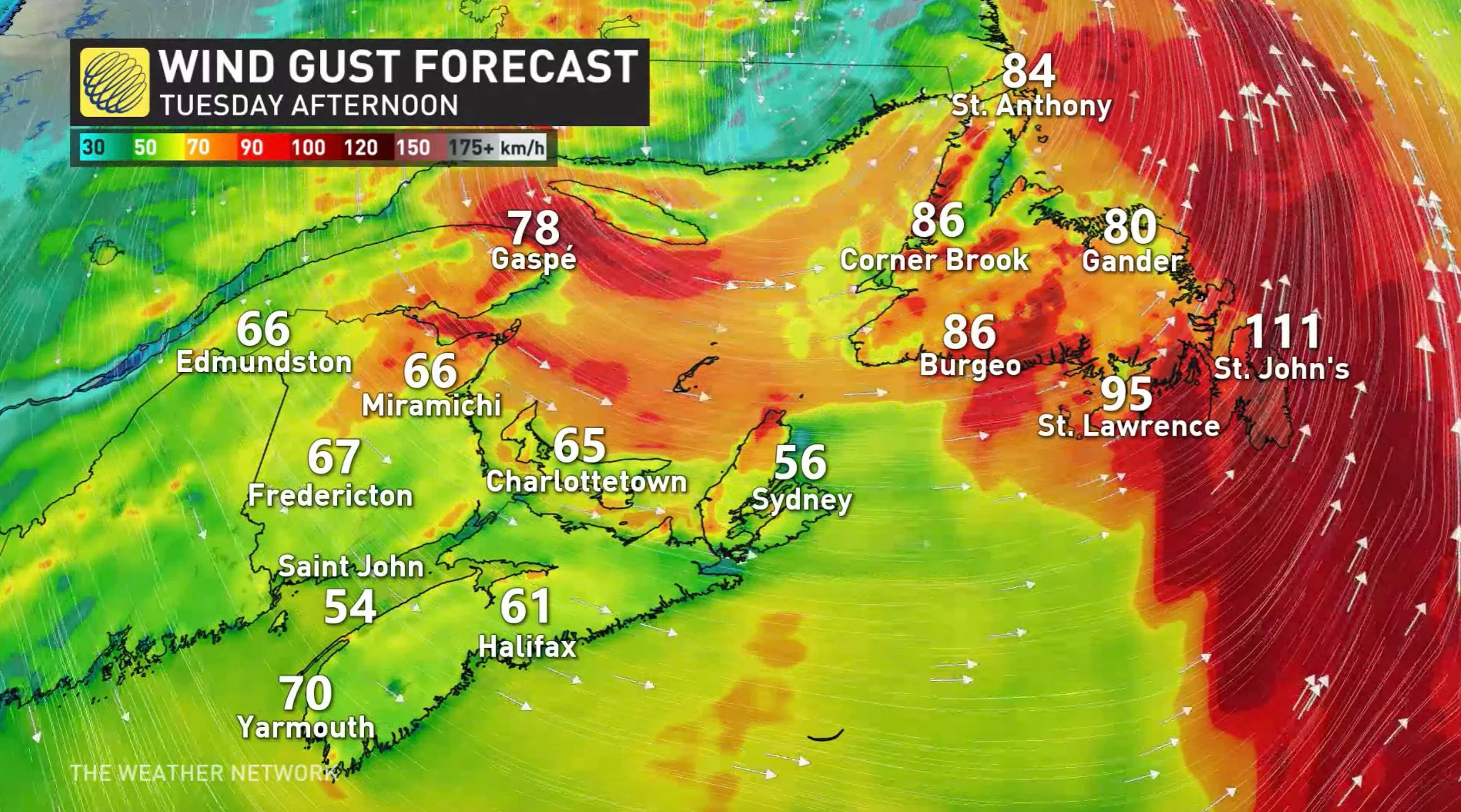
Rain hits Newfoundland, winds intensify through Tuesday, with 90-100 km/h gusts
LABRADOR: CRIPPLING BLIZZARD SHUTS DOWN SCHOOLS, CAUSES MAJOR TRAVEL DELAYS
After rolling through Ontario and Quebec on the weekend with a blast of widespread, heavy snow, a powerful storm is delivering its final, and most potent, early-winter blow to Newfoundland and Labrador.
Widespread winter-related warnings remain in effect for Labrador with 50-70+ cm of snow forecast across the region through Tuesday.
Before 9 a.m. local time, Happy Valley-Goose Bay had already picked up over 55 cm, with the snow falling at an unbelivable rate of 5-10 cm per hour. By just before 1:30 p.m., 65 cm was reported as snowfall rates began to slightly let up.
Combine the quickly falling snow with powerful winds, which are expected to persist throughout the day, and travel will be extremely dangerous and next to impossible.
Even as the snow begins to ease, northerly winds with gusts between 80-90 km/h have prompted blizzard warnings for central Labrador, with conditions not likely to improve much Tuesday. Travel delays and power outages will continue to be an issue across the region.
"Blizzard warnings are issued when widespread reduced visibilities of 400 metres or less are expected for at least 4 hours," says EC in the warning.
The quickly deteriorating conditions were enough to close schools in both Happy Valley-Goose Bay and North West River Tuesday morning, as well as the regional College of the North Atlantic campus.
"Please be advised that due to the extreme weather conditions, all Provincial Government offices in Central Labrador will be closed for the day," government officials also tweeted Tuesday morning.
The low picked up strength as it moved east, aided by a considerable temperature contrast and a cold upper trough interacting with milder air in the southwest. Additional moisture is also being pushed up the Eastern Seaboard of the United States, creating a setup that may result in an historic snowfall event.
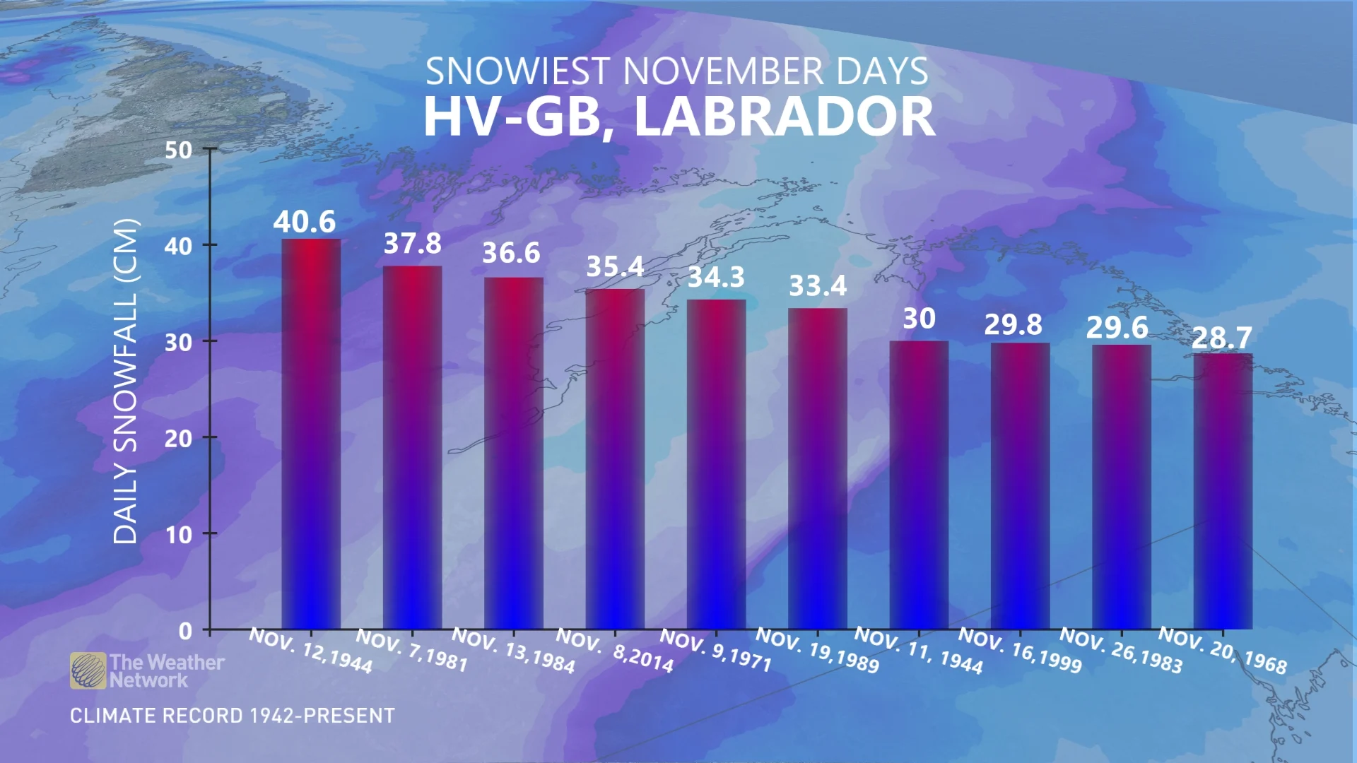
"59 cm of snow as of 9 a.m. at Happy Valley-Goose Bay. There is the potential to not only break their snowiest November day on record of 40.6 cm, but could also break their 2 day November snowfall record of 70.6 cm," says Weather Network meteorologist Matt Grinter.
NEWFOUNDLAND: HEAVY RAIN AND DAMAGING WINDS
The storm will also impact Newfoundland, as the precipitation -- mostly rain -- picks up in intensity and continues through Tuesday afternoon. By the time the rain moves out, rainfall totals may hit 20-40 mm in western portions of the island.
Widespread wind gusts of 80-90 km/h are also expected, possibly hitting 100 km/h, particularly in coastal areas. Wind and Wreckhouse wind warnings are in effect.
"Damage to buildings, such as to roof shingles and windows, may occur. Loose objects may be tossed by the wind and cause injury or damage," Environment Canada says in the warning.
Behind the system Tuesday afternoon, winds will shift to the southwest and create some sea-effect snow for the island. Winds will die down in the overnight hours.
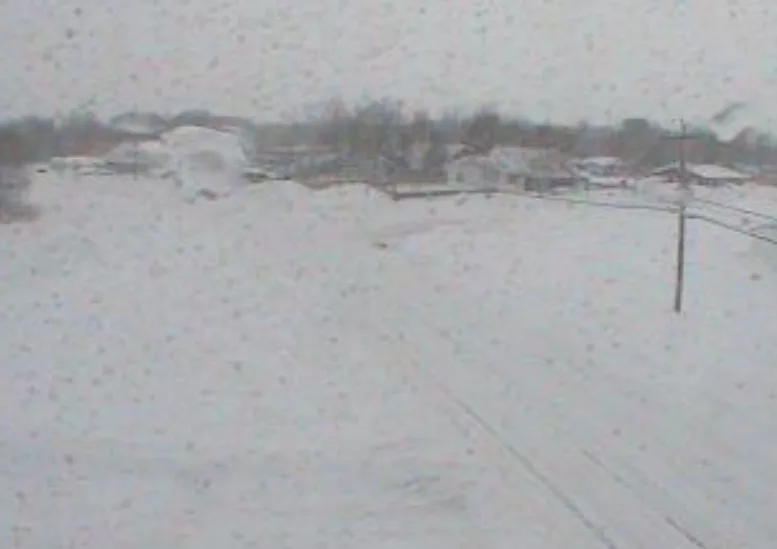
Thumbnail image courtesy: Happy Valley Goose Bay Live Camera – Labrador Region
Be sure to to check back for frequent weather updates in your area.