Big Labour Day weekend contrast, summer heat for some, fall-like for others

The last long weekend of the summer will be dramatically different from one part of the country to another, with a surge of summer warmth for some, and a fall preview for others.
Midway through the Labour Day long weekend, an unlikely part of the country is the winner as far as summer heat goes, while other areas see some very fall-like temperatures (with a touch of snow), and still others see a recovery that goes hand-in-hand with the chance of overnight rainfall.
Get the forecast details in your region, below.
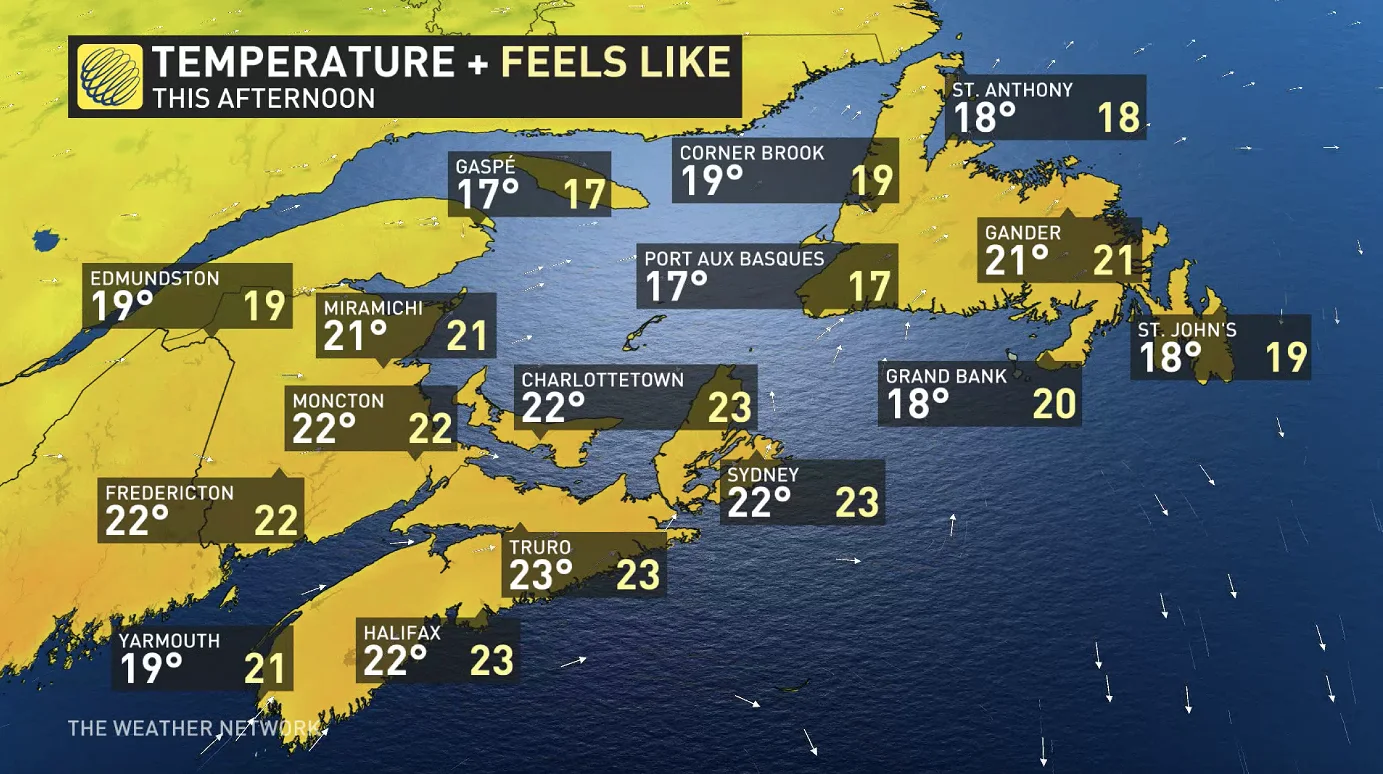
ATLANTIC CANADA
Showers opened up the long weekend in Newfoundland thanks to a passing cold front, but that's now exited the region, and the rest of the weekend looks to feature largely clear skies beneath high pressure.
Near-seasonal temperatures look to dominate, with daytime highs ranging from the high teens to low 20s. Many areas can expect the remaining mornings to start off with some fog, though burning off by the afternoon.
ONTARIO/QUEBEC
The weekend started off with some below-seasonal temperatures in southern parts of central Canada, but a surge of warmth will keep things largely in the mid-20s across the board Sunday.

However, though Sunday looks to stay clear and fair, a system will bring the chance of widespread though sporadic showers overnight into the early morning hours of Monday, largely confined to Ontario. Presently, it looks like thunderstorm risk will be low due to limited energy.
Beyond, Monday stays seasonal, but with a slight risk of non-severe thunderstorms north of Lake Erie and Lake Ontario.

As the heat builds across the south, much colder air will plunge into northern Ontario, bringing a taste of October-like weather. Single-digit highs and frost will creep in for Labour Day Monday and into early next week.
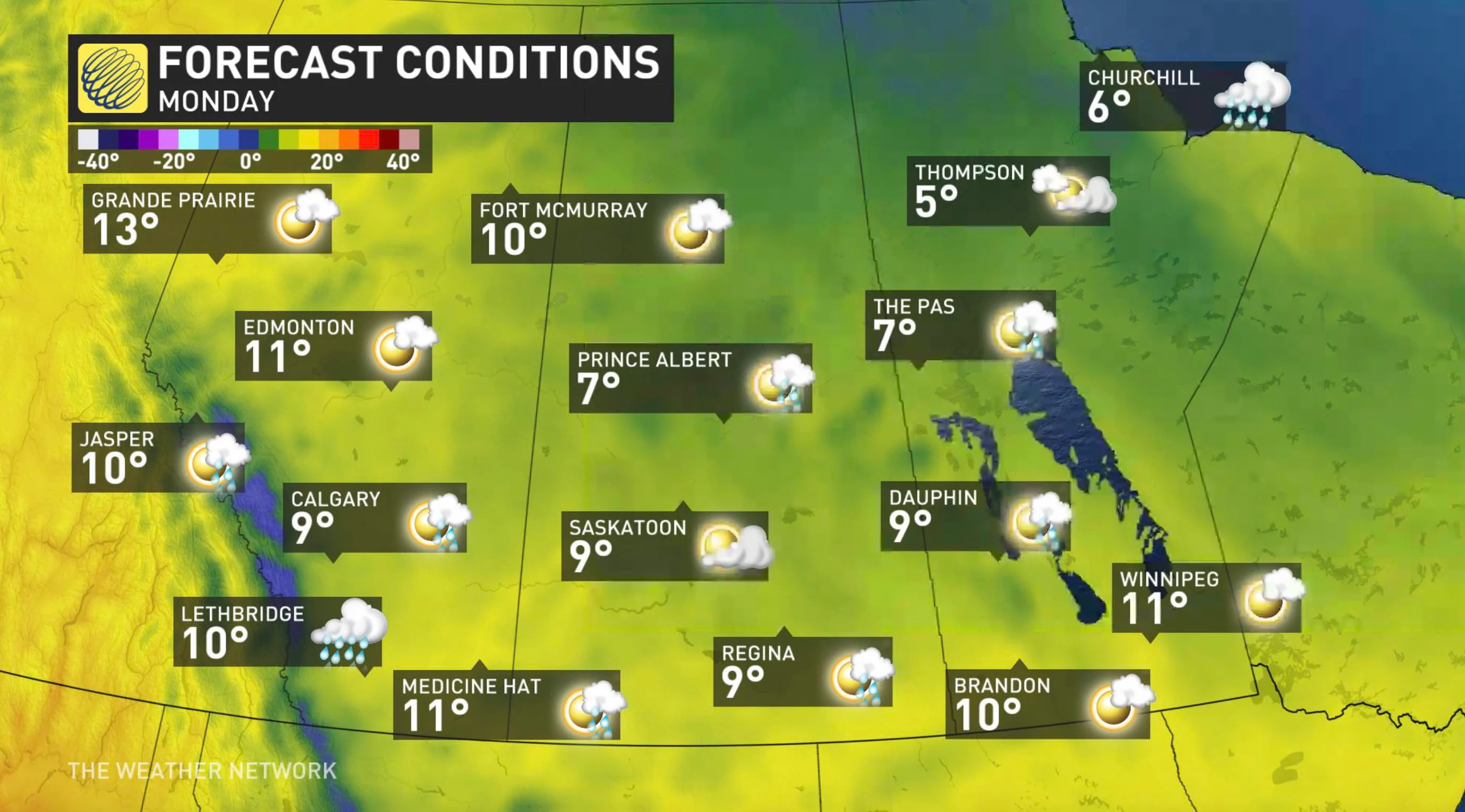
PRAIRIES
The remainder of the long weekend will definitely not live up to the false hope offered by Saturday, whose daytime highs in the high 20s and even in the low 30s for southern areas will have completely given way to a flow of incoming cold.
As such, almost no one can look forward to daytime highs above 20°C Sunday.

As a cold front slides across the region, it'll trigger showers Sunday night into Monday for parts of Alberta, but for areas in the mountains and foothills, it'll be cold enough for the system to manifest as snow.

Monday will feature some of the chilliest air in months for many areas, with widespread single-digit highs expected and the threat for frost, though temperatures do recover to something more seasonal through the following week.
BRITISH COLUMBIA
Uncommonly, it will be British Columbia where Canadians can expect proper summer-like weather as the season winds down, with daytime highs in the mid to high 20s across the board Sunday.
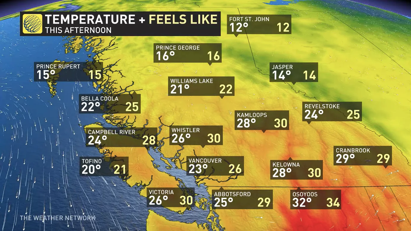
Parts of the north are likely to see some rain from Sunday night through to Monday morning from a cold front sliding southward along the Rockies, but the rain will mostly stay out of the southern parts of the province. Monday will largely be dry for the province, but people should prepare for strong winds in the front's wake, with southeasterly flow driving gusts up to 60 km/h -- a particular concern for firefighters trying to bring a number of blazes to heel.