The Atlantic Ocean’s high fever could fuel an ugly hurricane season

Water temperatures across the Atlantic are among the warmest we’ve ever seen this time of year—a terrible sign heading into hurricane season
Steamy water temperatures across the Atlantic Ocean are the main driver behind forecasts of an exceptionally active hurricane season later this year.
But just how hot is the ocean? Sea surface temperatures heading into the end of May were about where they should be in the middle of summer—and they’re likely going to warm even more as the heart of hurricane season arrives.
Here’s a look at the tremendous heat across the Atlantic Ocean and what effects it could have on the season ahead.
DON’T MISS: Ominous signs for hurricane season as Atlantic swelters, La Niña looms
Water temperatures are critical
Experts largely expect a very active hurricane season that could rank among historic years like 2005 and 2020, potentially seeing enough storms to exhaust the official list of names.

These predictions hinge on very favourable ingredients working together to create an environment where tropical disturbances have ample opportunities to develop and thrive.
The leading factor among them is exceptionally warm sea surface temperatures across much of the Atlantic Ocean.
Check out The Weather Network’s hurricane hub page for all the latest news and information you need during this upcoming season.

The average temperature of the entire North Atlantic during the last weekend of May was 20.5°C, which is more than 1.2°C warmer than normal for this time of year. Conditions are even hotter across the Main Development Region (MDR), the bustling ‘hurricane highway’ in the tropical Atlantic between the Caribbean and Africa.
Sea surface temperatures across the MDR are more than 1.3°C warmer than normal, with the Gulf of Mexico topping out with a whopping 1.5°C warm anomaly.
These are among the hottest temperatures ever observed this early in the year, far outpacing the historic stretch of all-time heat across the Atlantic Ocean throughout 2023. The ocean is far warmer now than it was ahead of the historic hurricane seasons of 2005 and 2020, each of which produced more than two-dozen storms.

RELATED: How hot water fuels the world’s most powerful hurricanes
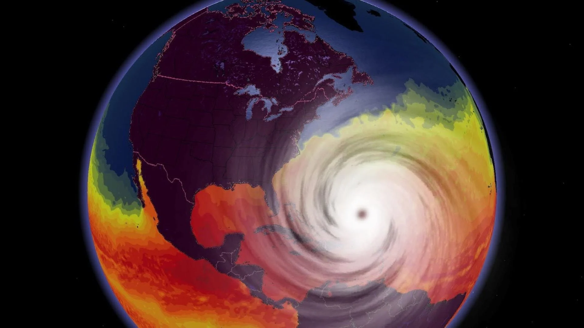
Hot water is the fuel that powers a hurricane. Hotter sea surface temperatures can allow more powerful hurricanes to develop.
Even worse is that warm water deep beneath the ocean surface can help temperatures rebound faster after a storm passes, serving to fuel the next storm that traverses the region.
WATCH: How mammoth hurricanes rapidly intensify in mere hours
La Niña combines with warmth to help storms thrive
Sea surface temperatures are only part of the equation when it comes to the health of a budding storm. Another critical factor that can make or break an Atlantic hurricane season is the pattern of El Niño and La Niña over in the neighbouring eastern Pacific.

La Niña is favourable to hurricanes in the Atlantic because it lessens the destructive wind shear that can shred apart a tropical disturbance before it has a chance to develop.
The combination of a very warm Atlantic and a growing La Niña through the heart of hurricane season will create an environment where any tropical disturbance has better odds of growing into a potentially dangerous system.
What it all means for the season ahead
Aside from the sheer number of storms this type of setup could foster, unusually toasty waters across the Atlantic Ocean are favourable for rapid intensification.
Most tropical systems evolve slowly and don’t grow too strong. Some storms, though, take full advantage of their environment and erupt.
Rapid intensification occurs when a tropical cyclone’s maximum sustained winds jump about 55 km/h in 24 hours. That’s the difference between a Category 1 and a major Category 3 hurricane.
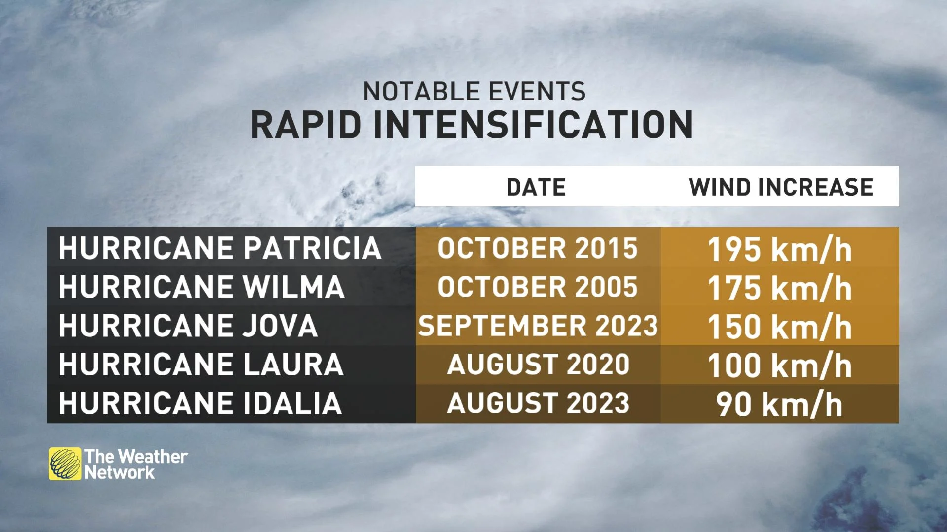
MUST SEE: How a mammoth hurricane rapidly intensifies in mere hours
Very warm waters are a key ingredient in rapid intensification. It’s likely that warmer oceans overall have led to more instances of swift strengthening over the past couple of decades. This year’s hot Atlantic temperatures are a grim harbinger for potential episodes of explosive development this season.
Even one storm is a hazard if it approaches land. A season that churns out one system after another poses a threat to everyone from Aruba to the Avalon Peninsula.

We also have to be on the lookout for impacts across Canada. An increase in the number of storms could mean more landfall possibilities on the East Coast.
Storms hitting the United States can also send remnants sweeping over Ontario, Quebec, and the Maritimes, which can bring widespread flooding rains, damaging winds, and even a threat for tornadoes.