This year's Fall Forecast blown away by super typhoons

As we head towards the heart of fall, we take a second look at the Fall Forecast and see what has gone right so far, what didn't transpire and examine other hiccups that brought some unexpected surprises in Canada
As we head into mid-October, it is time to revisit the Fall Forecast. While parts of it have worked out as expected, there have been some surprises and even some glaring errors that we need to address.
Our Fall Forecast highlighted the expectation that we would see a gentle start to the season with most of the country seeing near normal or warmer-than-normal temperatures, especially during the first half of autumn. Here is our original fall forecast map.
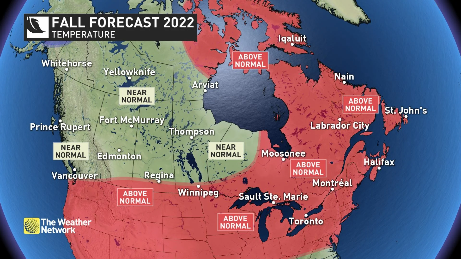
As we look back at the temperature pattern since Sept. 1, we can see that most of Canada has indeed been near normal or warmer than normal. The temperature anomaly map below has very little blue (colder-than-normal values) on it -- just like the forecast map.

However, the focus of the warmest weather has remained across Western Canada. Our expectation was that as we got deeper into fall, we would see a shift in the pattern with shots of colder weather coming into Western Canada while the eastern half would remain primarily warmer than normal.
While Atlantic Canada has been warmer than normal, we have seen several shots of colder weather in Manitoba, Ontario and Quebec, and that pattern will persist until the final week of October.
RELATED: Don't be fooled by Canada's gentle start to fall, storms are on the way
While a couple shots of cooler weather should always be expected as we progress through the fall season, we did not expect so many interruptions to the warm fall weather -- with even colder weather on the way, lasting through the third week of October.
Meanwhile, warmer than normal temperatures have dominated across B.C. and the western Prairies with record-breaking warmth and summer-like temperatures at times.
So, what happened to the forecast?
WATCH: Where are all the fall storms? Why things are about to change
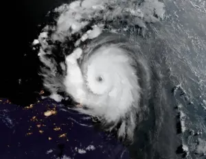
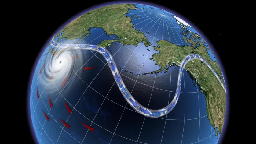
Every fall pattern is at risk to be disrupted by the impact that tropical systems have on the jet stream. More specifically, the track of typhoons in the western Pacific Ocean can reinforce or temporarily disrupt the jet stream pattern across the entire Northern Hemisphere.
So far this fall there have been five typhoons (including a couple of super typhoons) and a tropical storm with tracks that set off chain reactions in the atmosphere that helped to strengthen the ridge in the jet stream over Western Canada. That reinforced the warm pattern across that region. This in turn has caused the jet stream to dive south into the Great Lakes region, allowing for shots of colder weather to plunge into the eastern Prairies, Ontario and Quebec.
This type of interaction between the tropics and the jet stream is not unusual. However, typically after the jet stream has been disrupted, it is just a matter of time before it will trend back to roughly where it was before the disruption. However, with six storms having a similar impact on the jet stream during the past month, the disrupted pattern has become the dominant pattern.
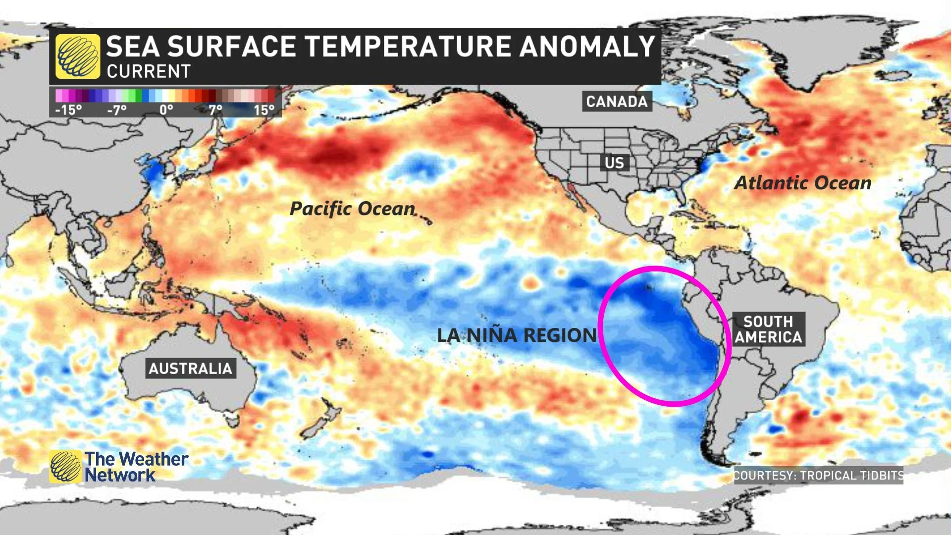
In addition, the La Niña pattern in the tropical Pacific is evolving in a way that reinforces the current pattern with the dip in the jet stream tending to be in the Great Lakes region.
SEE ALSO: What is La Niña? And how does it impact global weather?
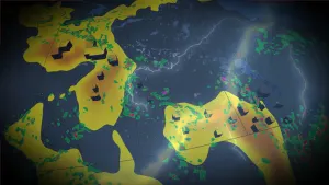
Typically during late fall and winter in a La Niña year, the focus of the coldest weather is across Western Canada. However, when the coolest ocean water temperatures (compared to normal) are located in the eastern Pacific -- just west of South America -- rather than in the central Pacific Ocean, there is a tendency for the coldest weather to be focused farther eastward, often reaching Ontario and Quebec.
The map below shows the ocean water temperature anomalies across the globe. The shades of dark blue circled on the map to the west of South America represent the colder water temperatures, compared to what we typically see in this region.
DON'T MISS: How to extend the time you spend outdoors this fall
Therefore, as we look ahead to the second half of October and early November, it appears that the current pattern will break down for a while, but it is unlikely that we will see a complete or long-lasting reversal of the pattern that we have seen since late September.
As a result, most of Western Canada will end up warmer than normal for the season as a whole. Meanwhile, much of Ontario and Quebec will end up near normal for the season as a whole, with a risk for parts of the region to be slightly cooler than normal.
Atlantic Canada is one region where our Fall Forecast is working out very well as temperatures and precipitation have been above normal. We also highlighted the heightened risk for this region to be impacted a couple of times by the remnants of tropical storms and hurricanes. That is the part of the forecast that we would have been happy to have busted, but unfortunately it verified as parts of the region were devastated by Fiona.
RELATED: Canada's October outlook - Slow slide or freefall into colder weather?
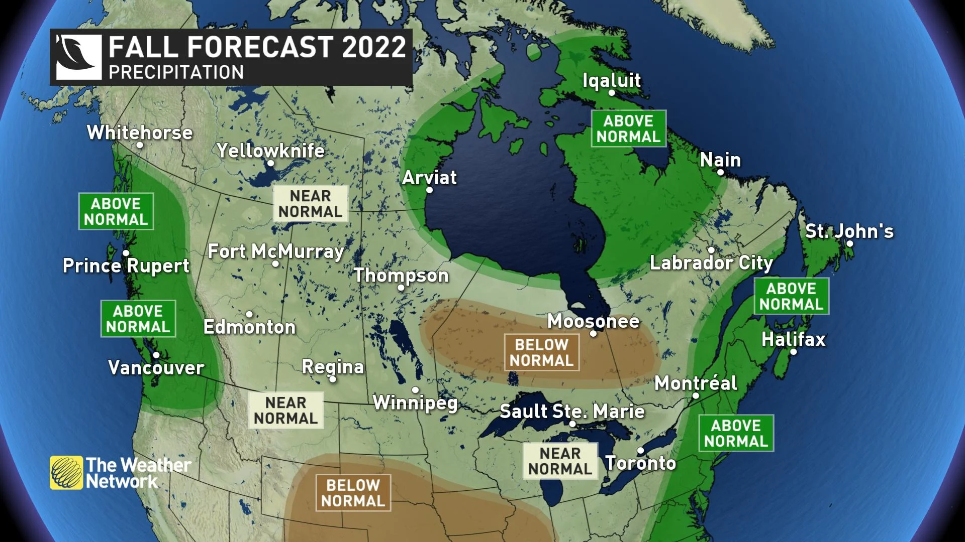
On the other hand, our precipitation forecast for B.C. is expected to bust. We did expect a dry pattern during the first half of the season, but not nearly as dry as we have seen. It is also clear that the flip to a wetter pattern will be later than expected as the ridge in the jet stream remains parked over the region through at least the end of next week.
Here is a look at the pattern that we expect will dominate during mid-October, through at least Oct. 20.
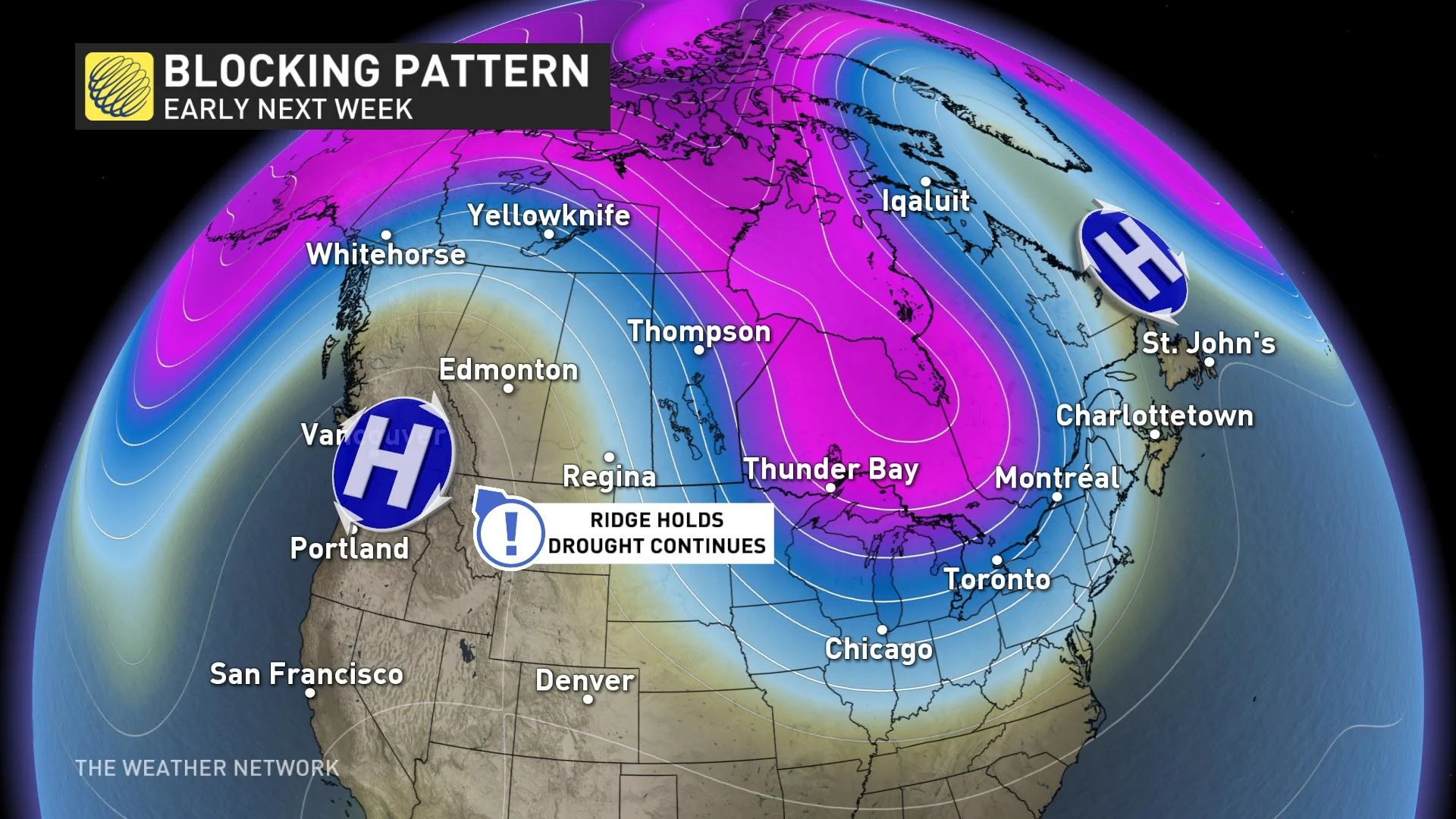
We still think that B.C. will flip over to a much wetter pattern during the final week of October and into November, with a risk for excessive rainfall at times, but at this point it is unlikely that we will see enough rain to verify the forecast.
Stay tuned to The Weather Network as we continue to track the fall conditions across Canada.