February's Fury: A punishing winter month for Canada

A look back at "February's Fury" that gripped the entire country. With these stats you'll see, no places were spared from winter's wrath last month.
As we welcome March, the first day of meteorological spring, it's still not feeling very spring-like for much of the country. In fact, a "remarkable" coast-to-coast cold pattern is set to dominate much of the country for the first half of the month as we welcome back the dreaded Polar Vortex.
From the snowiest month on record for one part of the country to the coldest temperatures since the Depression era, it's safe to say February proved what Canadian winters are all about.
Let's breakdown some of these jaw-dropping stats, below.
VICTORIA, B.C: SNOWIEST FEBRUARY ON RECORD
"This was a February of the ages," says Weather Network Meteorologist Chris Murphy.
As much as 68 cm of snow fell in Victoria, B.C. last month, a rare happening for the generally temperate city, making it the snowiest February on record.
Oddly enough, part of the reason the B.C.'s South Coast and Vancouver Island saw more snow than usual in February is the same reason the Prairies saw less -- intense Arcitc high pressure. The ridge of high pressure spurred both the extreme cold over the Prairies that fed Arctic outflow for southern B.C.'s coast, while at the same time shielding the Prairies from systems moving in from the Pacific and keeping the winter unusually dry.
WATCH BELOW: THIS SNOWY STAT MAY BLOW YOUR MIND, VICTORIA
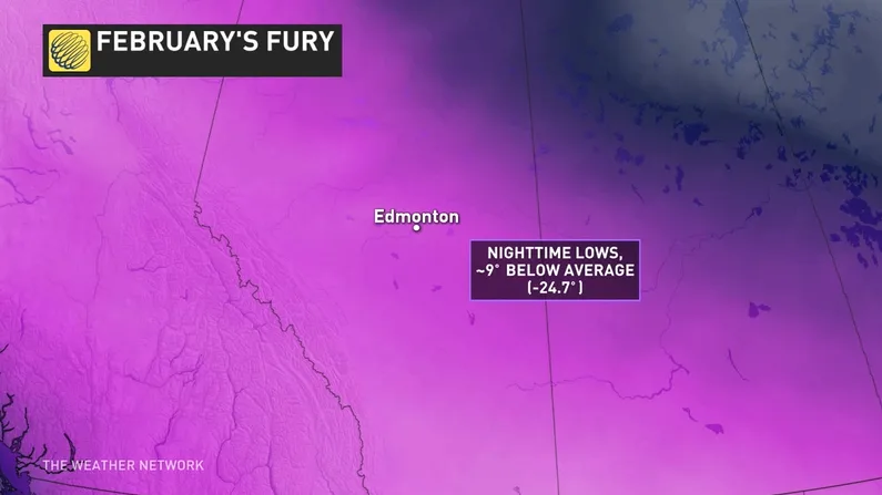
EDMONTON, ALBERTA DOESN'T CRACK THE FREEZING MARK ONCE
While the Prairies may have escaped the worst of the February snow, extreme and bone-chilling cold gripped the region with consecutive WEEKS of unbearable wind chills into the -40s and -50s.
The city of Edmonton made it through the entire month of February without even cracking the freezing mark once. Even more than that, the city recorded its coldest "mean temperature" since 1979 at a frigid -19°C for the month.
COLDEST FEBRUARY SINCE THE GREAT DEPRESSION IN SASKATCHEWAN
Saskatchewan as a whole fell victim to the fury of February with an extended period of bitter cold unseen since the 1930s.
Saskatoon's average temperature for the month of February is -12.5°C, but the city sat at about 13°C below normal for portions of the month. Meanwhile, Regina's monthly average temperature is -11.7°C and the city rounded out a February average that was also about 13°C below normal.
SEE ALSO: Two records going back more than 100 years broken in Sask.
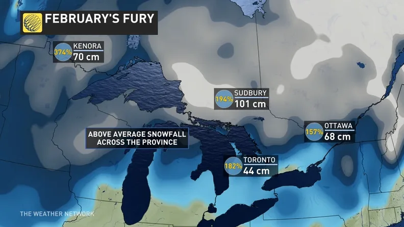
SNOW, SNOW AND MORE SNOW ACROSS ONTARIO
Heavy snow, blowing snow, blizzard snow, icy snow. You name the snow type and Ontario saw it throughout February. Back-to-back storms spanned much of the province giving major cities like Toronto enough snow to reach and surpass their YEARLY snow average. As of Tuesday, February 26, some 112 cm had fallen in the city, roughly four months since Pearson Airport's first recorded snowfall on October 27. An additional 18 cm fell on Wednesday amid another system that brought the area to a stand still.
Meanwhile, northern regions like Kenora and Sudbury saw upwards of 70 cm for the month of February alone, giving them more than double and triple their monthly snow average.
You likely won't hear any school students complaining about this one though, in what also seems to be a record amount of snow days for the month as well.
THE SNOW DAY DEBATE: A challenge for some, getting 'easier' for others
ROOF COLLAPSES UNDER THE WEIGHT OF HEAVY SNOW IN QUEBEC
February was the story of roof collapses in Quebec as the heavy and relentless accumulation of snow and ice became too much for several structures, including in Trois-Rivières on February 16 and a supermarket in Montreal's north shore area on February 25.
Police and fire officials were warning residents to "watch for signs of stress on roofs" and to clear snow if necessary after heavy snow and ice buildup.
MUST SEE: "INSANE" SNOW STATS IN QUEBEC THIS FEBRUARY
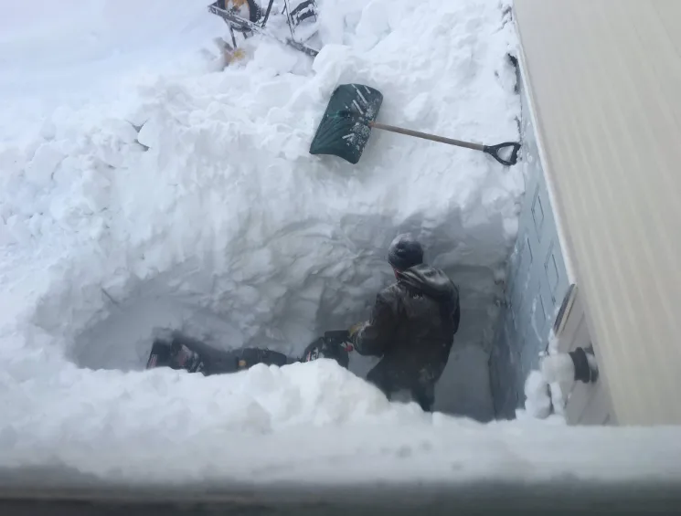
MAKKOVIK, LABRADOR: 100+ CM OF SNOW IN JUST THREE DAYS
Atlantic Canada is certainly no stranger to potent winter storms, with a major one-two punch actually setting up for this weekend. But it's the jaw-dropping photos that came out of Makkovik, Labrador that will have us remembering February as a winter doozy.
This is what 108 cm of snow in just three days looks like. Enough to leave some people shovelling out from their own front door.
Visit our Complete Guide to Spring 2019 for an in depth look at the Spring Forecast, tips to plan for it and much more
PATTERN CHANGE AHEAD
Despite the frosty start to March country-wide, there IS a light at the end of the tunnel. A pattern change is expected by mid March, allowing much milder weather to domimate during the second half of the month.
Wondering how the rest of spring will shape up? Check out our 2019 Spring Forecast PLUS an exclusive sneak peek at how summer is looking as well.
With files from meteorologists Caroline Floyd, Chris Murphy, Dr. Doug Gillham.
Thumbnail courtesy: Ashley Brauweiler