First look: Pattern reversal expected as Canada falls into winter

With the midway point of fall not far off, many Canadians are starting to wonder what winter will have in store for them. We have a sneak preview of what to expect during the upcoming season
Warmer than normal weather has dominated the fall season so far across most of Canada. The various shades of orange on the temperature anomaly map below highlight the areas where above normal temperatures have dominated since the beginning of September.

However, from the Great Lakes to New Brunswick, several shots of chilly weather since late September have offset the very warm conditions we saw during the first three weeks of the month. This region is currently running near normal for the season and parts of the region have even tipped to the cool side of normal.
As we look ahead to winter, can we expect that mild temperatures will continue to dominate across most of Canada?
SEE ALSO: Why does your long-range forecast change so often?
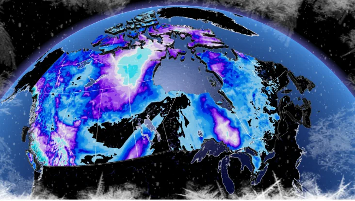
Our preliminary winter forecast highlights a major pattern change with widespread colder than normal temperatures for the season. In contrast to our 2022 Fall Forecast, which featured very little blue (colder than normal temperatures), our preliminary winter forecast features colder than normal temperatures for a large swath of the country's centre and near normal temperatures elsewhere. Only the southern parts of Atlantic Canada are expected to see above seasonal temperatures.

This week is providing many Canadians with an abrupt reminder that winter isn’t far away. Manitoba, Ontario and Quebec are seeing well below seasonal temperatures, and even heavy snow, across parts of the region. Are we now in a freefall into a long, cold winter?
The final week of October will bring a remarkable pattern reversal. For areas that have missed out on a warm fall, including southern Ontario and southern Quebec, we will see a period of above normal temperatures before we resume our inevitable slide into winter once we get into November. Meanwhile, Western Canada will turn much colder for the final week of October.
SEE ALSO: A 'Ring of Fire' solar eclipse happens one year from now. Start planning now!
As we look ahead to the second half of November through December, we expect a colder pattern will return to Ontario and Quebec, giving this region a quicker start to winter than we have become accustomed to seeing in recent years.
WATCH: Here's when exactly you should switch to winter tires
DON'T MISS: How to weatherproof your bedroom to help you get a better night's rest this fall
Now if you have a good memory, you are probably thinking, “hmmm...didn’t you say that last year?” Yes, we did, and that forecast did not pan out. So, I can’t blame you if you are skeptical.
Mild Decembers have become rather common over the past few decades across Eastern Canada, and with the busted forecast from last year still fresh on our mind, we held off on making any comment about the start of winter in our Fall Forecast.
However, so far this fall is clearly unfolding very differently from last fall. The signals in the global pattern continue to point to at least a near normal start to winter and possibly a colder than normal start to winter from the central Prairies to western Quebec. Here is our first look at what we expect from mid-November through to the holidays.

SEE ALSO: How to keep the mice out when the season changes
This is quite a contrast to what we saw last year when warmer than normal temperatures dominated from the Great Lakes to Atlantic Canada, while severe cold dominated across Western Canada.
As we look ahead to the heart of winter during January and February, there is still some uncertainty regarding the dominant pattern.
One possible scenario is that we will transition to a pattern that we often see during a La Niña winter, with colder than normal temperatures (including periods of severe cold) focused across Western Canada and milder temperatures across the eastern U.S., surging north into Eastern Canada at times. This is much like what we saw during early winter last year.

However, we are closely watching the potential for a pattern that more closely resembles what we saw last year in January and February, which featured milder weather across Western Canada and colder conditions from the central Prairies to the Maritimes.
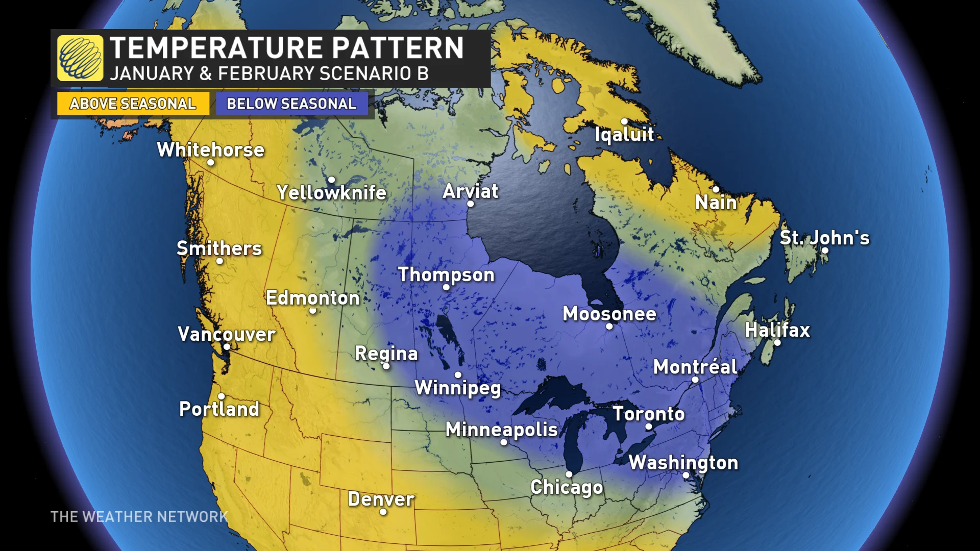
As we look at the different variables around the globe that will influence the winter pattern, there are currently some contradictory signals as to where the focus of the coldest weather will be located, and which areas will see more prolonged periods of mild weather.
However, at this point, scenario B looks to have more support as we look at how the global pattern is evolving. But it is unlikely that we will lock into that pattern for the entire winter, so at times we expect the national pattern will resemble the first scenario.
It is also worth noting that we are now into the third year of the current La Niña pattern. Third-year La Niña winters have only happened a few times in recorded history and the global pattern at this time is quite different from what we saw during those other occasions. That adds an extra element of mystery to how the winter pattern will unfold.
Be sure to check back on November 30th when we will release our final Winter Forecast, including details on what we expect across each region of the country and our snowfall forecast.