Extremely cold morning ahead for Ontario before warmup arrives

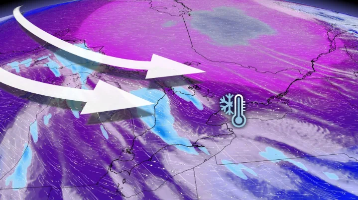
Widespread extreme cold warnings cover much of Ontario as a blast of frigid Arctic air reaches the province to start the weekend.
A quick blast of dangerously cold conditions will take hold of Ontario through Saturday, posing a serious threat to health and safety of anyone outdoors for too long without proper protection. Widespread extreme cold warnings cover most of the province.
MUST SEE: Huge temperature rebound coming for Eastern Canada–but there’s a catch
"Risks are greater for young children, older adults, people with chronic illnesses, people working or exercising outdoors, and those without proper shelter," says Environment and Climate Change Canada (ECCC) in the extreme cold warning. "Dress warmly. Dress in layers that you can remove if you get too warm. The outer layer should be wind resistant."

Actual air temperatures this cold are bad enough, but windy conditions behind the front will make for even colder wind chill values, leading to a high risk for frostbite on exposed skin within minutes for many communities.
An Arctic front is responsible for this blast of cold air.
For some perspective on how unusually cold this is, the average high and low in Toronto is 0°C and -5°C, respectively, with these seasonal benchmarks coming in at -3°C and -12°C in Ottawa.
DON’T MISS: Understanding the warning signs of frostbite
Gusty winds blowing that Arctic air into Ontario will make the feels-like value plunge into the -30s and even approach -40, especially in eastern Ontario. Wind chill values this cold will make it dangerous to spend more than a brief moment outside without running the risk of injuring unprotected skin.

The combination of cold air and gusty winds will also lead to the continued threat for snow squalls blowing off Lake Huron and Georgian Bay. Snow squalls will last into Saturday before diminishing as a clipper moves into the region.
The combination of heavy snow and gusty winds will lead to reduced visibility and periods of blowing and drifting snow. Between 10-20+ cm of snow is possible in some of the hardest-hit areas through Sunday.

Quick and dramatic temperature rebound for Sunday
While Saturday morning will certainly pack a punch in terms of extreme temperatures, expect a dramatic temperature rebound as early as Sunday. Daytime highs for many will rise above freezing.
OUTLOOK: Fickle February: Hit and run winter continues to lack commitment
Much milder temperatures will dominate next week, as well, along with the potential for a couple of systems. The first system will bring primarily rain showers, gusty winds and very mild temperatures on Tuesday. Another system is expected later in the week though with lower confidence on the timing, but a higher potential for some ice and snow for parts of the region.
Above seasonal temperatures are expected to dominate through mid-February, but winter could attempt a come back late in the month.
Stay with The Weather Network as we track the dangerous cold across Ontario.