Atlantic: Beware of slick, icy roads as temperatures plunge by 15+ degrees

Temperatures take a quick and steady tumble across the Maritimes, with warnings of black ice as wet surfaces freeze.
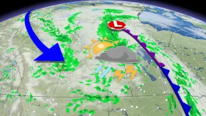
The messy and moisture packed system that hit the Maritimes with a mix of miserable weather on Tuesday will continue to bring heavy rain across western Newfoundland through Wednesday. That's as temperatures significantly plunge making for some slick and icy conditions on wet surfaces. For parts of Nova Scotia for example, temperatures have fallen more than 15 degrees since Tuesday afternoon. More on what's left of this system and how long the cold conditions last, below.
WEATHER HIGHLIGHTS:
Temperatures take a huge nosedive through Wednesday for Maritimes
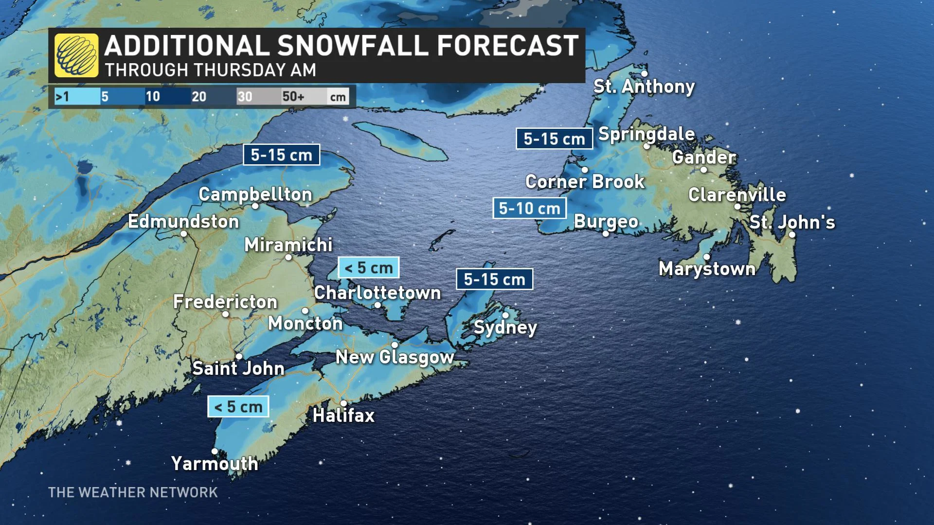
Sea-effect snow picks up behind front for P.E.I., Nova Scotia
Rain, milder temperatures for Newfoundland Wednesday, changing to snow through evening
Stay up-to-date on the ALERTS in your area
WATCH BELOW: TIMING THE RAIN AND SEA-EFFECT SNOW
Atlantic Canada was a land of contrasts on Tuesday, as strong southerly flow preceded the potent system in the east and cold air flooded down behind it in the west.
The line between across New Brunswick was sharp through most of the day, while snow piled up in the north and rain came down in the south. Fredericton marked the dividing line, starting the day with snow, then changing to rain through the day before switching back to snow again in the evening.
Nova Scotia was home to Canada's hotspots on Tuesday, as temperatures climbed into the mid-teens for many, reaching nearly 17ºC in Grand Étang, on Cape Breton Island. It's a much different story on Wednesday however, as the system's cold front quickly dropped temperatures to near the freezing mark.
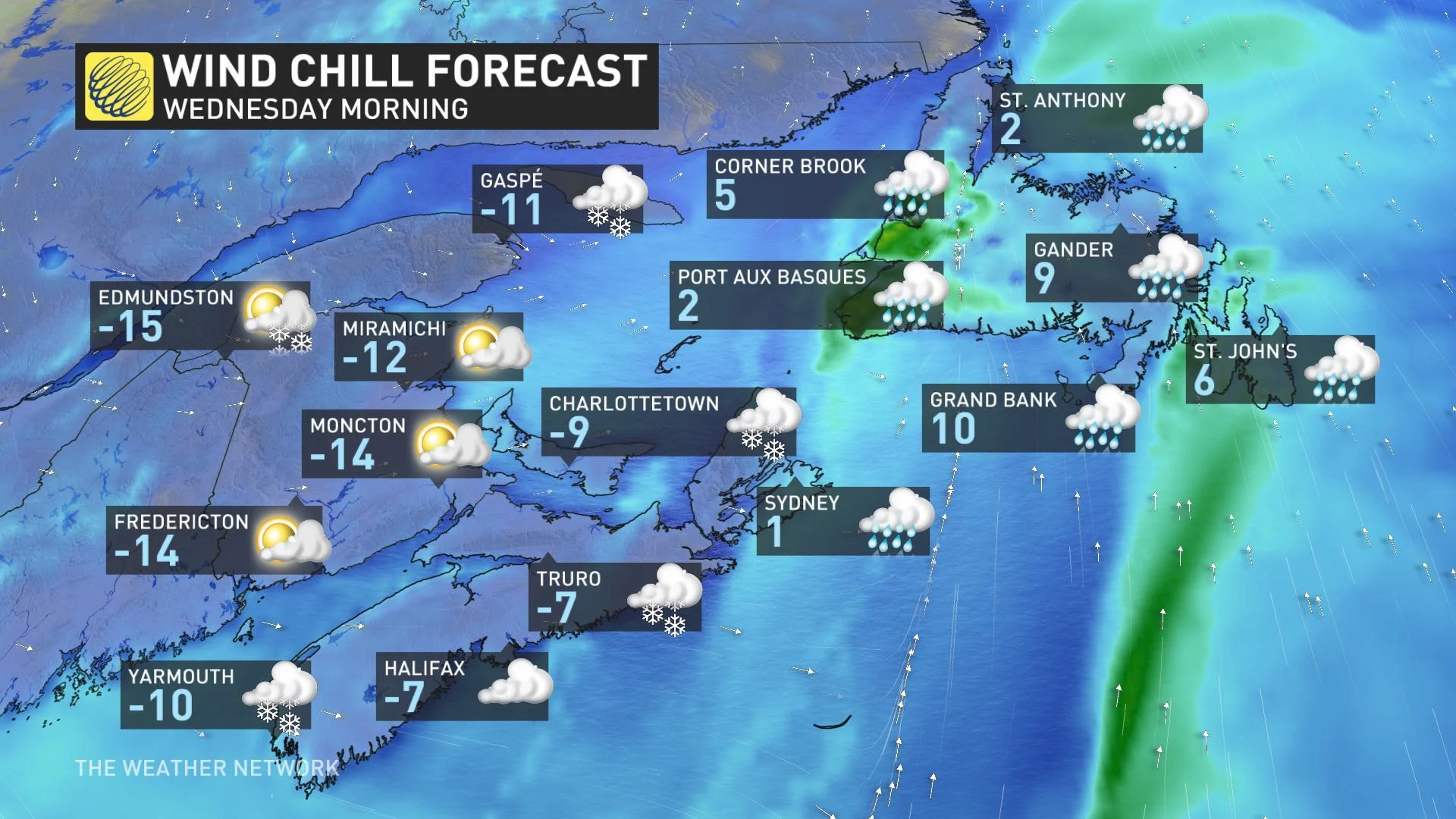
Wind chills were even in the minus double digits for parts of the Maritimes early Wednesday, making for some of the coldest air of the season to date.
"This is the first time I've had to scrape the windshield in Halifax," said The Weather Network's Nathan Coleman.
Drivers have been urged to prepare for slick travel conditions amid the significant temperature drop. Motorists may also have to contend with a quick shot of snow as winds pick up from the west-northwest, making for favourable conditions for the development of snow squalls. Snow squall watches are in effect for many exposed coastal areas in P.E.I. and Nova Scotia.
"Driving conditions will become hazardous due to snow, blowing snow, and high winds," Environment Canada warns.
Newfoundland will hang onto the warmth, along with the rain, for another day longer with temperatures pushing the mid-teens on Wednesday afternoon. In fact, the Avalon is forecast to be the national hotspot for the day as St. John's reaches a balmy November 16°C day. But those milder conditions are set to crash right back down into Thursday and Friday.
"A system tracking to the north will drag another cold front across the region Friday night and Saturday with rain and snow showers expected once again," says meteorologist Dr. Doug Gillham.
This front will tap into subtropical moisture and become a more significant system for Newfoundland on Saturday with rain changing to snow and strong winds expected as well.
"Heavy snow totals are forecast for western Newfoundland, but less than 2 cm is likely for the Avalon," Gillham adds.
Frigid weather is expected behind the front with strong and gusty northwest winds resulting in some sea effect snow.
Stay tuned to The Weather Network for the latest forecasts.